|
REFINE
Browse All : H2004-135, Bishop
1-16 of 16
Title
Fort Kearney, South Pass, and Honey Lake Wagon Road Preliminary Map (Lander's Cut-off)
Date
1857-1858
Description
Fort Kearney, South Pass, and Honey Lake Wagon Road Preliminary Map (Lander's Cut-off) 1857-by FW Lander and WH Wagner, includes roads, rivers, creeks, passes, gaps, railroads, cities, towns, mountains, photostatic copy
Category - Type
Map-Trail or Road
Title
Fort Laramie to Cheyenne Pass Route
Date
1858
Description
Route from Fort Laramie to Cheyenne Pass by BVT Major Williams with orders to establish a post, includes sketch of Camp Walbach and Pedistal Rock
Category - Type
Military-Camp Walbach
Title
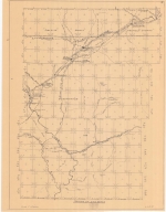
Torrington, USGS topographical map; includes Township 24 - Township 35 , Range 58-Range 76
Date
1954
Description
Torrington, USGS topographical map; includes Township 24 - Township 35, Range 58-Range 76
Category - Type
Map-Topo
Title
Casper Area Topographic Map Township 24-Township 25, Range 77-Range 94
Date
1955
Description
Casper Area Topographic Map by US Geological Survey, includes Township 24-Township 35, Range 77-Range 94
Category - Type
Map-Topo
Title
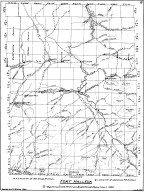
Fort Bridger Map
Date
1958
Description
Fort Bridger Map by LC Bishop, includes Township 13-26, Ranges 111-120. Emigrant Road, 2 copies
Category - Type
Military-Fort Bridger
Title
Parting of the Ways Map
Date
1958
Description
Parting of the Ways Map by LC Bishop, includes townships, ranges, rivers, creeks, roads, trails, pony express stations, stage stations, graves, 2 copies
Category - Type
Map-Trail or Road
Title
Wyoming Map
Date
1958
Description
WY Map by US Geological Survey, Emigrant Road. Key Map by LC Bishop, 2 copies
Category - Type
Map-State
Title
Fort Caspar, Independence Rock & South Pass Map
Date
1959
Description
02 Fort Casper, Independence Rock & South Pass Map by LC Bishop, includes townships, ranges, rivers, creeks, roads, trails, pony express stations, graves, 2 paper copies
Category - Type
Military-Fort Caspar
Title
Fort Laramie & Fort Fetterman Map
Date
1959
Description
01 Fort Laramie & Fort Fetterman Map, by LC Bishop, includes townships, ranges, rivers, creeks, roads, trails, pony express stations, graves
Category - Type
Military-Fort Laramie
Title
Fort Bridger Map
Date
1959-1960
Description
04 Fort Bridger Map by LC Bishop, includes townships, ranges, rivers, creeks, roads, trails, pony express stations, graves, 2 paper copies
Category - Type
Military-Fort Bridger
Title
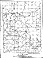
Fort DA Russell Map
Date
1959-1960
Description
06 Fort DA Russell Map, by LC Bishop, includes townships, ranges, rivers, creeks, roads, trails, pony express stations, graves, drawing of Camp Walbach, drawing of Pedestal Rock by Brt Major Williams
Category - Type
Map-Trail or Road
Title
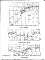
Fort Halleck Map
Date
1959-1960
Description
08 Fort Halleck Map, by LC Bishop, includes townships, ranges, rivers, creeks, roads, trails, pony express stations, graves, stage stations, abandoned railroad stations, 2 copies-1 sheet vellum, 1 sheet paper
Category - Type
Military-Fort Halleck
Title
Fort Sanders Map
Date
1959-1960
Description
07 Fort Sanders Map by LC Bishop, includes townships, ranges, rivers, creeks, roads, trails, pony express stations, graves, stage stations, abandoned railroad stations
Category - Type
Military-Fort Sanders
Title
Landers Cut Off, East & West Section Map
Date
1959-1960
Description
05 Landers Cut Off, East & West Section Map by LC Bishop, includes townships, ranges, rivers, creeks, roads, trails, pony express stations, graves, 2 copies
Category - Type
Map-Trail or Road
Title
Pony Express Route Centennial map, 1860-1960
Date
1960
Description
Pony Express Route Centennial, 1860-1960, by LC Bishop & Paul Henderson. Includes stations and distances, as well as a separate time table fo the WY Section of the Pony Express re-run
Category - Type
Map-Trail or Road
Title
Fort Laramie area map, includes Township 23 - Township 30, Range 60 - Range 69
Date
Undated
Description
Fort Laramie area map, includes Township 23 - Township 30, Range 60 - Range 69. Shows roads and locations of events
Category - Type
Military-Fort Laramie
1-16 of 16
|