|
REFINE
Browse All : H2007-3 and Map-Survey of 3
1-11 of 11
Title
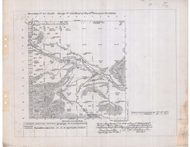
Survey Map Township 41, Range 106, Sections 1 - 36
Date
1892
Description
Survey Map by Wm A. Richards, surveyed by Carpenter & Warner, US Surveyor General's Office, Township 41, Range 106, Sections 1 - 36, includes topo info, Big Wind River, roads, ditch, creeks, date of contract, amount of survey, survey dates, magnetic declination, 1 set with 1 sheet negative paper
Category - Type
Map-Survey
Title
Survey Map Township 38, Range 89, Sections 1 - 36
Date
1894
Description
Survey Map by Perry Birkford, surveyed by Shannon & Gilcrest, US Surveyor General's Office, Township 38, Range 89, Sections 1 - 36, includes topo info, Okie Post Office to Casper Road, road, Table Land, creeks, total number of acres, date of contracts, amount of surveys, 1 set with 1 sheet negative paper
Category - Type
Map-Survey
Title
Survey Map Township 39, Range 89, Section 5 - 8, 17 - 20, 29 - 32
Date
1894
Description
Survey Map by Perry Birkford, surveyed by Shannon & Gilcrest, US Surveyor General's Office, Township 39, Range 89, Section 5 - 8, 17 - 20, 29 - 32, includes topo info, Okie Store & Post Office, Casper to Okie Post Office Road, Carbon to Okie Road, Okie Post Office to Basin Road, Carbon to Basin Road, creeks, total number of acres, date of contracts, amount of surveys, 1 set with 1 sheet negative paper
Category - Type
Map-Survey
Title
Survey Map Township 36, Range 89, Sections 1 - 36
Date
1898
Description
Survey Map by Alpheus P. Hanson, surveyed by J. Frank Warner, Charles A. Honey, John E. Shannon, Coleman & Gilcrest, US Surveyor General's Office, printed-The Norris Peters Co., Township 36, Range 89, Sections 1 - 36, includes topo info, Deer Creek Flat, creeks, total number of acres, date of contracts, amount of surveys, No 4699, 1 set with 1 sheet negative paper
Category - Type
Map-Survey
Title
Survey Map Township 39, Range 89, Sections 1 - 4, 9 - 16, 21 - 28, 33 -36
Date
1898
Description
Survey Map by Alpheus P. Hanson, surveyed by J. Frank Warner, Shannon & Gilcrest, Charles A. Honey, US Surveyor General's Office, printed-The Norris Peters Co., Township 39, Range 89, Sections 1 - 4, 9 - 16, 21 - 28, 33 -36, includes Road to Lost Cabin, topo info, creeks, total number of acres, date of contracts, amount of surveys, 1 set with 1 sheet negative paper
Category - Type
Map-Survey
Title
Resurvey Map Sheet 1 Township 12, Range 86, Sections 1 - 18
Date
1923
Description
Resurvey Map Sheet 1 by Clyde W. Atherly, US Surveyor General's Office, surveyed by Roy E. Chase & Alex Douglas AV Richards, includes Township 12, Range 86, Sections 1 - 18, Wyoming & Colorado border, tracts, topo info, sectional correction line, roads, creeks, land ownership, Index to Segregated Tracts with legal description, entry no. & status, entryman name; Patented Mineral Claim Table with survey no. & name; amount of surveys, No. 723, 2 sets-1 with 1 sheet neg paper & 1 with 1 sheet pos paper
Category - Type
Map-Survey
Title
Resurvey Map Township 13, Range 87, Sections 1 - 36
Date
1923
Description
Resurvey Map by Clyde W. Atherly, US Surveyor General's Office, surveyed by Adams & Schuch, Roy E. Chase, includes Township 13, Range 86, Sections 1 - 18, tracts, topo info, sectional correction line, roads, creeks, land ownership, Patented Mineral Patented Mineral Claim Table with survey no. & claim name; Areas of sub-tracts of Tract 39, amount of surveys, No. 924. 1 with 1 sheet negative paper
Category - Type
Map-Survey
Title
Survey Map Township 15, Range 83, Sections 1 - 36
Date
1880
Description
Survey Map by Edw C. David, surveyed by Wm O. Downey, US Surveyor General's Office, printed-A Gast & Co, Township 15, Range 83, Sections 1 - 36, includes topo info, Road to Fort Steele, Cherokee Road, roads, creeks, North Platte River landowner info-J Moody, A Baggott, Jas Parr, GH Nichols, E. Nichols, WS Perryam, McFales, total number of acres, date of contracts, amount of surveys, No. 643, 535, 1 set with 1 sheet negative paper
Category - Type
Map-Survey
Title
Survey Map Township 23, Range 83, Sections 1 - 36
Date
1883
Description
Survey Map by Edw. C David, US Surveyor General's Office, surveyed by JB Shelby, Thomas B. Medary, printed-A Gast & Co, Township 23, Range 83, Sections 1 - 36, includes topo info, Austin's Ranch to Fort Steele Road, creeks, total number of acres, dates of contracts, amount of surveys, magnetic declination, 1 set with 1 sheet negative paper
Category - Type
Map-Survey
Title
Survey Map Township 24, Range 83, Sections 1 - 36
Date
1883
Description
Survey Map by Edw. C David, US Surveyor General's Office, surveyed by JB Shelby, Downey & Grant, printed-A Gast & Co, Township 24, Range 83, Sections 1 - 36, includes topo info, Fort Steele Road, Medicine Bow River, coal outcropping, creeks, total number of acres, dates of contracts, amount of surveys, magnetic declination, No. 2196, 1 set with 1 sheet negative paper
Category - Type
Map-Survey
Title
Reduced Fort Bridger Military Reservation Survey Map Township 15 Range 115, Sections 27 - 34, Township 16, Range 115, Sections 3 - 5, 8 - 10, 15 - 17, 20 - 22
Date
1892
Description
Reduced Fort Bridger Military Reservation Survey Map by Wm A. Richards, surveyed by WM Gilcrest, US Surveyor General's Office, Township 15 , Range 115, Sections 27 - 34, Township 16, Range 115, Sections 3 - 5, 8 - 10, 15 - 17, 20 - 22, includes topo info, roads, ditch, National Cemetery, Carter, Sage Flat, Tank & Pumphouse, store, telephone line, total number of acres, dates of contracts, amount of surveys, magnetic declination, 1 set with 1 sheet negative paper
Category - Type
Map-Survey
1-11 of 11
|