|
REFINE
Browse All : Map-Mineral of Guernsey
1-3 of 3
Title
Charles Guernsey Mining Claims in the Canon Mining District survey date, patent date, (Sunrise Mine)
Date
1892 Circa
Description
Charles Guernsey Mining Claims in the Canon Mining District, Township 27 Range 65 & 66, Township 28, Range 67, includes mine name & boundary, survey number, table-with lode name, date, survey date, patent date, blueprint (loaned for copy by Homesteader Museum)
Category - Type
Map-Mineral
Title
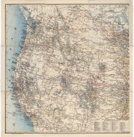
Western United States Map, Guernsey Steel Company Map
Date
1908
Description
Western US Map, Guernsey Steel Company Map includes Pacific with sailing desination distances, state boundaries, mountain relief, lakes & river courses, railroad lines, cities, part of Canada also included for railroad routing purposes, longitude 97-131 degrees, west, latitude 31-53 north. Index of principal railraods is extensive.
Category - Type
Map-Mineral
Title
Guernsey, WY-Primary Types of Mineral Deposits for Magnesium Reduction Industry
Date
1942
Description
Guernsey, WY-Primary Types of Mineral Deposits for Magnesium Reduction Industry, WY State Engineer General Subject Map, may include forests, trails, railroads, geology, improvements & industry, 1 set with 1 sheet paper
Category - Type
Map-Mineral
1-3 of 3
|