|
REFINE
Browse All : Map-Nat'l Park of CD
1-3 of 3
Title
Devils Tower National Monument Special Topo Map
Date
1949
Description
Devils Tower National Monument Special Topo Map, by US Department of Interior Geological Survey, includes Township 53, Range 65 - Range 66, types of roads, building locations & names, river and creek, springs, trails, 1 set with 1 sheet colored paper
Category - Type
Map-Nat'l Park
Title
Yellowstone National Park brochure
Date
1982
Description
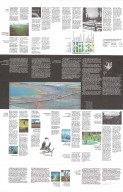
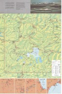
Yellowstone National Park brochure, includes vicinity maps, colored topo info, roads, trails, lakes, rivers, visitor use facilities, geographic descriptions, continental divide, elevations, legend, boundary, state lines; Reverse side-interpretive & educational info re. what to do, safety, visitor services, wildlife, thermal features, general ecology. Double-sided.
Category - Type
Map-Nat'l Park
1-3 of 3
|


