|
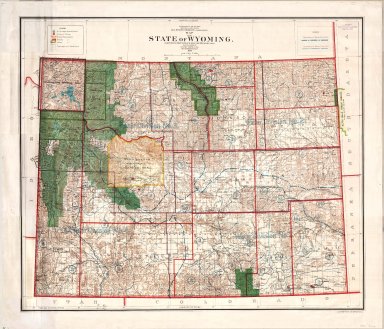
Title
Wyoming Map
Date
1900
Description
WY Map by US Dept of Interior, General Land Office includes surveyor general's office, US Land offices, townships, ranges, Indian reservations, military reservations, forest reserves 3 copies ( 1 reverse positive)-not colored map?
Category - Type
Map-State
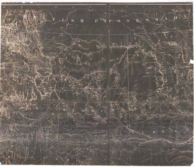
Title
Wyoming Map
Date
1868 Circa
Description
WY Map, includes portions of Nebraska, Dakota, Montana, Idaho, Colorado, Utah, cities, towns, forts, railroads, rivers, creeks, mountains, Indians, 1 partial map, negative, paper
Category - Type
Map-State
Title
Wyoming Map
Date
1868 Circa
Description
WY Map, includes portions of Nebraska, Dakota, Montana, Idaho, Colorado, Utah, cities, towns, forts, railroads, rivers, creeks, mountains, Indians, 1 partial map, negative, paper
Category - Type
Map-State
Title
Wyoming Map
Date
1869
Description
WY Map (accompanied the annual report of the commissioner of the general land office) 2 copies 1 partial-negative, 1 copy
Category - Type
Map-State
Title
Wyoming Map
Date
1875 Circa
Description
WY Map includes townships, ranges, rivers, 20 mile limit, Indian reservations page 86 (5 County Map)
Category - Type
Map-State
Title
Wyoming Map
Date
1875 Circa
Description
WY Map drawn by WM Masi for JH Triggs' History of Cheyenne & Northern WY includes rivers, creeks, railroads, forts, wagon roads and trails, mountains
Category - Type
Map-State
Title
Wyoming Map
Date
1876
Description
WY Map by US Dept of Interior, General Land Office Includes Surveyor general's office, Land offices, townships, ranges, military reservations, Indian reservations, cities, towns, railroad, forts, rivers, creeks, 3 copies, 2 Negative, 2 Positive - cites National Archives
Category - Type
Map-State
Title
Wyoming Map
Date
1879
Description
WY Map by US Dept of Interior, General Land Office includes Surveyor General's office, Land offices, townships, ranges, cities, towns, rivers, creeks, railroad, 20 mile limit, forts, military reservations, Indian reservations, includes Pease County 2 copies, 1 Mylar
Category - Type
Map-State
Title
Wyoming Map
Date
1879 Circa
Description
WY Map, No Citation Information includes townships, ranges, rivers, camps, 20 mile limits 2 copies page 86
Category - Type
Map-State
Title
Wyoming Map
Date
1883
Description
WY Map, Holts, linen
Category - Type
Map-State
Title
Wyoming Map
Date
1886
Description
WY Map by George Cram includes cities, towns, reserves, rivers, creeks page 73
Category - Type
Map-State
Title
Wyoming Map
Date
1886
Description
WY Map by George Cram includes cities, towns, reserves, rivers, creeks page 73
Category - Type
Map-State
Title
Wyoming Map
Date
1886
Description
WY Map by George Cram includes cities, towns, reserves, rivers, creeks page 73
Category - Type
Map-State
Title
Wyoming Map
Date
1886
Description
WY Map by George Cram includes cities, towns, reserves, rivers, creeks page 73
Category - Type
Map-State
Title
Wyoming Map
Date
1888
Description
WY Map by US Dept of Interior, General Land Office includes surveyor generals office, land office, Indian & military, townships, ranges, railroad land grant, oil & coal fields, geological features from survey by Gilbert Barney, 1 linen backed colored map
Category - Type
Map-State
Title
Wyoming Map
Date
1888
Description
WY Map by US Dept of Interior, General Land Office includes surveyor generals office, land office, Indian and military, townships, ranges, railroad land grant, oil & coal fields, geological features from survey by Gilbert Barney, colored map, 3 copies
Category - Type
Map-State
Title
Wyoming Map
Date
1890
Description
WY Map includes townships, ranges, index, cities, towns, rivers, creeks, mountains pages 236, 237
Category - Type
Map-State
Title
Wyoming Map
Date
1890 Circa
Description
WY Map includes counties, cities, townships, ranges, creeks, Indian Reservation, National Park, mountains, rivers & creeks, mining districts, ranches, index-on back, 1 set with 1 sheet colored paper
Category - Type
Map-State
Title
Wyoming Map
Date
1892
Description
WY Map by US Dept of Interior, General Land Office includes surveyor general's office, US Land offices, townships, ranges, incomplete railroads, stage stations, 1 sheet colored linen backed paper
Category - Type
Map-State
Title
Wyoming Map
Date
1892
Description
WY Map by US Dept of Interior, General Land Office includes surveyor general's office, US Land offices, townships, ranges, incomplete railroads, stage stations, 1 sheet colored linen backed paper
Category - Type
Map-State
Title
Wyoming Map
Date
1895
Description
WY Map by Rand McNally
Category - Type
Map-State
Title
Wyoming Map
Date
1900
Description
WY Map by US Dept of Interior, General Land Office includes surveyor general's office, US Land offices, townships, ranges, Indian reservations, military reservations, forest reserves 3 copies ( 1 reverse positive)-not colored map?
Category - Type
Map-State
Title
Wyoming Map
Date
1900
Description
WY Map by US Dept of Interior, General Land Office includes surveyor general's office, US Land offices, townships, ranges, Water Divisions & Districts, Indian reservations, military reservations, forest reserves, 1 linen backed paper copy
Category - Type
Map-State
Title
Wyoming Map
Date
1900
Description
WY Map by US Dept of Interior, General Land Office includes surveyor general's office, US Land offices, townships, ranges, Indian reservations, military reservations, forest reserves, 2 copies
Category - Type
Map-State
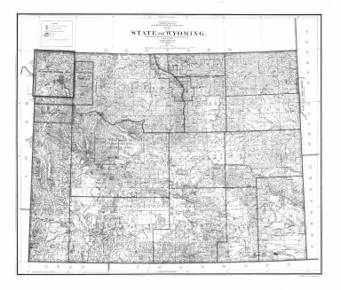
Title
Wyoming Map
Date
1905
Description
WY Map by US Dept of Interior includes US surveyor general's office, US land offices, townships, ranges, Indian reservations, military reservations, forest reserves, national parks & monuments, bird reserves, land district boundaries
Category - Type
Map-State
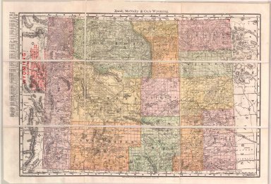
Title
Wyoming Map
Date
1906
Description
WY Map by Kenyon Printing & Manufacturing Co. copyrighted in 1906 by George F Cram index to towns, counties and railroads on back, Stockgrowers National Bank stamped on front Xerox copy. Map includes townships & ranges, counties, cities & towns, railroads, mountains & hills, rivers and lakes, 1 set with 1 sheet xerox paper
Category - Type
Map-State
Title
Wyoming Map
Date
1907
Description
WY Map by US Dept of Interior includes US surveyor general's office, US land offices, townships, ranges, Indian reservations, military reservations, forest reserves, national parks & monuments, bird reserves, land district boundaries 3 copies
Category - Type
Map-State
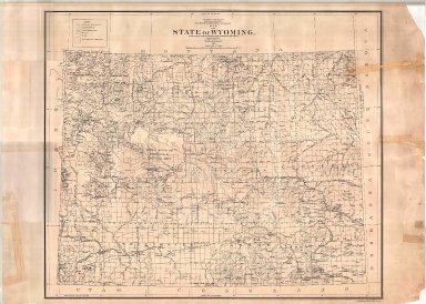
Title
Wyoming Map
Date
1912
Description
WY Map by the US Dept of Interior includes US surveyor general's office, US Land offices, townships, ranges, Indian reservations, military reservations, forest reserves, national parks & monuments, bird reserves, land district boundaries, colored paper, 2 copies
Category - Type
Map-State
Title
Wyoming Map
Date
1913
Description
WY map showing petroleum withdrawals outstanding on 9/30/1916. Map includes state line, latitude & longitude, counties with boundries & townships, federal reservations, river courses, towns, Indian Reservation.
Category - Type
Map-State
Title
Wyoming Map
Date
1915
Description
WY Map by Pubic Service Commission, Robert Forsyth, Herman B. Gates, HA Floyd, includes townships, ranges, counties, cities, towns, roads, highways, railroads, rivers, creeks, forests, population statistics
Category - Type
Map-State
Title
Wyoming Map
Date
1916
Description
WY Map by US Geological Survey, IP Berthrong, includes townships, ranges, cities, towns, counties, index to gauging stations, principal drainage basin boundaries, railroads, national forests, mountains, rivers, creeks, US Land Offices, 1 sheet linen backed colored paper
Category - Type
Map-State
Title
Wyoming Map
Date
1916
Description
WY Map by US Department of Interior, IP Berthrong, includes townships, ranges, cities, towns, counties, railroads, national forests, mountains, rivers, creeks, US Land Offices, colored
Category - Type
Map-State
Title
Wyoming Map
Date
1916
Description
WY Map by the US Geological Society includes gauging stations, lands with irrigated water rights, surface waters, plate 1 from the office of the state engineer
Category - Type
Map-State
Title
Wyoming Map
Date
1931
Description
WY Map by the US Dept of Interior includes public survey offices, land offices, townships, ranges, grazing districts, national forests, Indian reservations, military reservations, bureau of reclamation projects, national parks, monuments
Category - Type
Map-State
Title
Wyoming Map
Date
1937
Description
WY Map by US Dept of Interior, US Geological Survey, cartographer AF Hassan includes townships, ranges, counties, rivers, creeks, cities, towns, railroads, national forests, reservoirs, color coding of plant types (penciled on map), 1 map, linen backed
Category - Type
Map-State
Title
Wyoming Map
Date
1937
Description
WY Map Showing the State Highway System by the WY Highway Dept, includes counties, cities, towns, highways, forests, Indian reservation, 1 sheet blueline paper
Category - Type
Map-State
Title
Wyoming Map
Date
1939
Description
WY Map by the National Map Company includes townships, ranges, rivers, creeks, cities, towns, airports, index OVERSIZED
Category - Type
Map-State
Title
Wyoming Map
Date
1941
Description
WY Map by WPA includes tours of historic sites, cities, towns, rivers, creeks, mountains, highways, roads, paper, blueline 3 copies
Category - Type
Map-State
Title
Wyoming Map
Date
1941
Description
WY Map by WPA includes tours of historic sites, cities, towns, rivers, creeks, mountains, highways, roads, paper, blueline 3 copies
Category - Type
Map-State
Title
Wyoming Map
Date
1947
Description
WY Map by US Dept of Interior includes public survey office, district land offices, grazing districts, national forests, Indian reservations, military reservations, bureau of reclamation projects, national parks, monuments, wildlife refuges
Category - Type
Map-State
Title
Wyoming Map
Date
1948
Description
WY Map, includes passes in the Continental Divide, paper
Category - Type
Map-State
Title
Wyoming Map
Date
1950 Circa
Description
WY Map showing Radioactive Anomalous by Cheyenne Photo Print, includes townships, ranges, cities, towns, counties, rivers, creeks, railroads, highways, national forests, Indian reservation, paper
Category - Type
Map-State
Title
Wyoming Map
Date
1953
Description
WY Map by the US Dept of Interior, Geological Survey includes townships, ranges, railroads, creeks, towns
Category - Type
Map-State
|