|
REFINE
Browse All : Map-Survey and H2007-3 of 2
1-30 of 30
Title
Survey Map Township 21, Range 66, Sections 1 - 36
Date
1872
Description
Survey Map by Silas Reed, surveyed by John B. Thomas, Henry G. Hay, US Surveyor General's Office, Township 21, Range 66, Sections 1 - 36, includes topo info, rivers, Fort Laramie Stage Road, road, total number of acres, date of contracts, amount of surveys, 1 set with 1 sheet negative paper
Category - Type
Map-Survey
Title
Survey Map Township 36 Range 82, Sections 1 - 36
Date
1883
Description
Survey Map by Edw. C. David, surveyed by FO Sawin, JB Menardi, US Surveyor General's Office, printed-A Gast & Co, Township 36, Range 82, Sections 1 - 36, includes topo info, Alkali Hills, deposit of bones locations, creeks, total number of acres, date of contracts, amount of surveys, No. 1725, 1247, 1 set with 1 sheet negative paper
Category - Type
Map-Survey
Title
Survey Map Township 40, Range 105, Sections1 - 36
Date
1892
Description
Survey Map by Wm A. Richards, surveyed-Carpenter & Warner, US Surveyor General's Office, Township 40, Range 105, Sections1 - 36, incl topo info, Indian Trail, Wind River, Shoshone/Wind River Indian Reservation, Initial Monument, Bonneville National Forest , road, creeks, No. 4374, 1 set with 1 sheet negative paper
Category - Type
Map-Survey
Title
Survey Map Township 41, Range 105, Sections 1 - 36
Date
1892
Description
Survey Map by Wm A. Richards, surveyed by Carpenter & Warner, US Surveyor General's Office, Township 41, Range 105, Sections 1 - 36, includes topo info, Wind River, Shoshone/Wind River Indian Reservation, bad lands, road, creeks, 1 set with 1 sheet negative paper
Category - Type
Map-Survey
Title
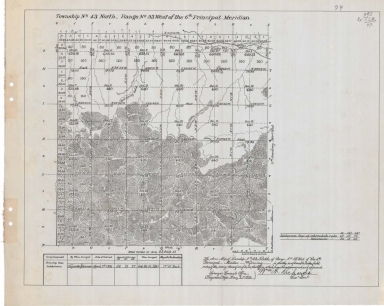
Survey Map Township 43, Range 93, Sections 1 - 36
Date
1892
Description
Survey Map by Wm A. Richards, surveyed by Carpenter & Warner, US Surveyor General's Office, printed-A Gast & Co, Township 43, Range 93, Sections 1 - 36, includes topo info, road, spring, creeks, total number of acres, dates of contracts, amount of surveys , magnetic declination, No 4396, 1 set with 1 sheet negative paper
Category - Type
Map-Survey
Title
Survey Map Township 43, Range 95, Sections 1 - 12, 15 - 21
Date
1892
Description
Survey Map surveyed by Carpenter & Warner, US Surveyor General's Office, Township 43, Range 95, Sections 1 - 12, 15 - 21, includes Wind River or Shoshone Indian Reservation Boundary, topo info, roads, creeks, total acres surveyed, No. 1972, 1 set with 1 sheet negative paper
Category - Type
Map-Survey
Title
Survey Map Township 44, Range 95, Sections 13, 18 - 36
Date
1892
Description
Survey Map by Wm A. Richards, surveyed by Carpenter & Warner, US Surveyor General's Office, printed-A Gast & Co, Township 44, Range 95, Sections 13, 18 - 36, includes topo info, creeks, total number of acres, dates of contracts, amount of surveys, magnetic declination, No 4418, 1 set with 1 sheet negative paper
Category - Type
Map-Survey
Title
Survey Map, Township 44, Range 93, Sections 1 - 36
Date
1892
Description
Survey Map, surveyed by Carpenter & Warner, US Surveyor General's Office, Township 44, Range 93, Sections 1 - 36, includes topo info, road, cliffs, coal croppings, creeks, total number of acres, dates of contracts, amount of surveys magnetic declination, No 4398, 1 set with 1 sheet negative paper
Category - Type
Map-Survey
Title
Survey Map Township 42, Range 109, Sections 1 - 36
Date
1893
Description
Survey Map by Wm A. Richards, surveyed by Carpenter & Warner, US Surveyor General's Office, Township 42, Range 109, Sections 1 - 36, includes topo info, roads, creeks, Continental Divide, total number of acres, dates of contracts, amount of surveys, magnetic declination, Accession No. 4510, 2611, 1 set with 1 sheet negative paper
Category - Type
Map-Survey
Title
Survey Map Township 43, Range 109, Sections 19 - 36
Date
1894
Description
Survey Map by Perry Birkford, surveyed by Carpenter & Warner, US Surveyor General's Office, Township 43, Range 109, Sections 19 - 36, includes topo info, Wind River, creeks, Sheridan's Trail, Black Rock Trail, roads, Bonneville National Forest, total number of acres, date of contracts, amount of surveys, No. 4512, 2613, 1 set with 1 sheet negative paper
Category - Type
Map-Survey
Title
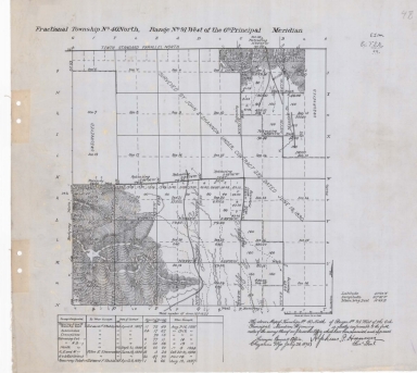
Fractional Survey Map Township 40, Range 91, Sections 1 - 2, 11 - 12, 19 - 22, 26 - 35
Date
1898
Description
Fractional Survey Map by Alpheus P. Hanson, surveyed by Edward F. Stahle, John E. Shannon, US Surveyor General's Office, printed-The Norris Peters Co., Township 40, Range 91, Sections 1 - 2, 11 - 12, 19 - 22, 26 - 35, includes topo info, roads, creeks, total number of acres, date of contracts, amount of surveys, 1 set with 1 sheet negative paper
Category - Type
Map-Survey
Title
Resurvey Map Township 38, Range 93, Sections 1 - 36
Date
1898
Description
Resurvey Map by Alpheus P. Hanson, surveyed by EF Stahle, JE Shannon, US Surveyor General's Office, printed-The Norris Peters Co., Township 38, Range 93, Sections 1 - 36, includes Lander & Lost Cabin Road, Road to McGrath's, Road to Johnson's, topo info, creeks, total number of acres, date of contracts, amount of surveys, No. 4666, 1 set with 1 sheet negative paper
Category - Type
Map-Survey
Title
Resurvey Map Township 40, Range 93, Sections 1 - 36
Date
1898
Description
Resurvey Map by Alpheus P. Hanson, surveyed by EF Stahle, JE Shannon, US Surveyor General's Office, printed-The Norris Peters Co., Township 40, Range 93, Sections 1 - 36, includes road, Johnson's barn & house, ditch, Unsurveyed Impassable notation, topo info, creeks, total number of acres, date of contracts, amount of surveys, No. 4668, 1 set with 1 sheet negative paper
Category - Type
Map-Survey
Title
Retracement Map Township 41, Range 93, Sections 1 - 36
Date
1898
Description
Retracing Map by Alpheus P. Hanson, surveyed by EF Stahle, Carpenter & Warner, US Surveyor General's Office, printed-The Norris Peters Co., Township 41, Range 93, Sections 1 - 36, includes road, Lander to Thermopolis Road, Hot Springs Wagon Trail, topo info, creeks, total number of acres, date of contracts, amount of surveys, No. 4672, 2 sets with 1 sheet negative paper
Category - Type
Map-Survey
Title
Fractional Survey Map Township 44, Range 109, Sections 1 - 36
Date
1899
Description
Fractional Survey Map by Alpheus P. Hanson, US Surveyor General, US Department of Interior, surveyed by Warner & Fink, Carpenter & Warner, includes Township 44, Range 109, Sections 1 - 36, tracts, topo info, creeks, lakes, Impassable notation, Sectional Correction Line, contract dates, amount of surveys, group no.survey dates, No. 4708, 1 set with 1 sheet negative paper
Category - Type
Map-Survey
Title
Fractional Survey Map Township 42, Range 95, Section 1 - 30
Date
1900
Description
Fractional Survey Map by Alpheus P. Hanson, surveyed-Edward F. Stahle, US Surveyor General's Office, printed-The Norris Peters Co., Township 42, Range 95, Sec 1 - 30, incl Shoshone Indian Reservation North Boundary, Hay Road, Road to Lander, roads, creeks Lander to Thermopolis Road, wagon roads, Adam's House, Nicklson's House, Earl's House, Koeppe's House, Slate's House, McCoy's House, topo info, Big Horn River, total no of acres, date of contracts, amount of surveys, No 4741, 1 set with 1 sheet neg paper
Category - Type
Map-Survey
Title
Fractional Survey Map Township 43, Range 95, Section 1 - 30
Date
1900
Description
Fractional Survey Map by Alpheus P. Hanson, surveyed by Edward F. Stahle, US Surveyor General's Office, printed-The Norris Peters Co., Township 43, Range 95, Sec 1 - 30, includes Road to Lander, Road to Embar, wagon roads, cemetery road, Thermopolis Road, topo info, Big Horn River, Island, State Land, total no of acres, date of contracts, amount of surveys, No 1973, 1 set with 1 sheet negative paper
Category - Type
Map-Survey
Title
Survey Map Township 20, Range 82, Sections 1 - 36
Date
1878
Description
Survey Map by Edw C. David surveyed by LM Lampton, WO Downey, US Surveyor General's Office, printed-A. Gast & Co., Township 20, Range 82, Sections 1 - 36, includes topo info, roads, Sheep Mountain, Mineral Lands, creeks, roads, total number of acres surveyed, date of contracts, amount of surveys. Accession No. 582, 493, 2 sets with 1 sheet negative paper.
Category - Type
Map-Survey
Title
Survey Map Township 12, Range 89, Sections 1 - 18
Date
1881
Description
Survey Map by Edw C. David, surveyed by GW Baker, AV Richards, US Surveyor General's Office, printed-A Gast & Co, Township 12, Range 89, Sections 1 - 18 includes Colorado border, topo info, Jim Baker's House, Gordon Road's barn & house, Hahn's Peak Road, school house, log house, corral, hay stack, swamp, cliffs, gulches, creek, Mineral Land-designation, total number of acres, date of contracts, amount of surveys, No. 736, 1 set with 1 sheet negative paper
Category - Type
Map-Survey
Title
Survey Map Township 22, Range 72, Sections 1 - 36
Date
1881
Description
Survey Map by Edw. C David, surveyed by Alfred M. Rogers, Moore & Owen, Henry G. Hay, US Surveyor General's Office, printed-A Gast & Co, Township 22, Range 72, Sections 1 - 36, topo info, rivers, Mineral Land, total number of acres, date of contracts, amount of surveys, magnetic declination, No. 793, 603, 2 sets with 1 sheet negative paper
Category - Type
Map-Survey
Title
Survey Map Township 30 Range 99, Sections 1 - 36
Date
1884
Description
Survey Map by Edw. C David, surveyed by Wm B. Yerby, JL Propst, US Surveyor General's Office, printed-A Gast & Co, Township 30 Range 99, Sections 1 - 36, incl. Miners Delight townsite, Green River to Fort Washakie Road, Miners Delight to Phil Wise's Road, roads, mineral land, flag poles, sluices, rocky ledge, irrigation ditch, topo info, creeks, total number of acres, date of contracts, amount of surveys, magnetic declination, Accession No. 3070, 1 set with 1 sheet negative paper
Category - Type
Map-Survey
Title
Supplemental Plat 4 resurvey Township 52, Range 93, Sections 16 - 17
Date
1913
Description
Supplemental Plat 4, by Charles L. Decker, US Surveyor General, surveyed by Emil Voigt, AD Davis, US Department of Interior, includes resurvey Township 52, Range 93, Sections 16 - 17, tracts, Big Horn River, Discovery Oil Placer, Mineral Survey No., No. 3612, 1 set with 1 sheet negative paper
Category - Type
Map-Survey
Title
Supplemental Plat 1 Township 47, Range 63, Section 31
Date
1923
Description
Supplemental Plat 1 by Clyde W. Atherly, US Surveyor General, Township 47, Range 63, Section 31, includes lot subdivision to accommodate mineral entry-oil placer claim, 1 set with 1 sheet negative paper
Category - Type
Map-Survey
Title
Independent Resurvey Map Township 51, Range 60, Sections 4 - 9, 16 - 21, 28 - 33
Date
1933
Description
Independent Resurvey Map by Frank M. Johnson-US Supervisor of Surveys, DH Parrott-Acting Assistant Commissioner, surveyed by Marvin J Lytle, Edward F Stahle on, US Department of Interior, includes Township 51, Range 60, Sections 4 - 9, 16 - 21, 28 - 33, List of Mineral Claims with locations, topo info, rivers, acreage area of mineral survey & resurvey, Accession No. 290, 1 set with 1 sheet negative paper
Category - Type
Map-Survey
Title
Survey Map Township 20, Range 85, Sections 1 - 36
Date
1876
Description
Survey Map by Edw C. David surveyed by Wm O. Downey, Wm B. Yerby, US Surveyor General's Office, printed-A. Gast & Co., Township 20, Range 85, Sections 1 - 36, includes topo info, Fort Steele Military Reservation boundary, North Platte River, plateaus, creeks, total number of acres surveyed, date of contracts, amount of surveys. No. 495, 424. 2 sets with 1 sheet negative paper
Category - Type
Map-Survey
Title
Survey Map Township 23, Range 85, Sections 1 - 36
Date
1883
Description
Survey Map by Edw. C David, US Surveyor General's Office, surveyed by JB Shelby, printed-A Gast & Co, Township 23, Range 85, Sections 1 - 36, includes topo info, O'Brien's Spring to Fort Steele Road, sandstone wall, total number of acres, dates of contracts, amount of surveys, magnetic declination, No. 2201. 1 set with 1 sheet negative paper
Category - Type
Map-Survey
Title
Survey Map Township 24, Range 82, Sections 1 - 36
Date
1883
Description
Survey Map by Edw. C David, US Surveyor General's Office, surveyed by JB Shelby, Downey & Grant, printed-A Gast & Co, Township 24, Range 82, Sections 1 - 36, includes topo info, Chas Smith's ranch, Austin's Ranch to Fort Steele Road, Smith's Ranch to Carbon Road, Austin's Ranch to Benned's Road, Austin's wire fence line, Medicine Bow River, creeks, roads, total number of acres, dates of contracts, amount of surveys, magnetic declination, No. 2194, 1 set with 1 sheet negative paper
Category - Type
Map-Survey
Title
Fort Steele Military Reservation Survey Map Township 21, Range 85, Sections 1 - 36 Steele Rawlins
Date
1888
Description
Fort Steele Military Reservation Survey Map by John Charles Thompson, surveyed-Wm O. Owen, US Surveyor General's Office, printed-A Gast & Co, Township 21, Range 85, Sections 1 - 36, includes topo info, Steele & Rawlins, Road, Union Pacific Railroad track, Steele & Saratoga Telephone Line, roads, building & cemetery locations, creeks, total number of acres, date of contracts, amount of surveys, magnetic declination, No. 496. 2 sets with 1 sheet negative paper
Category - Type
Map-Survey
Title
Survey Map Township 51, Range 103, Sections 1 - 36
Date
1884
Description
Survey Map by Edw. C David, surveyed by NJ Burnham, US Surveyor General's Office, printed-A Gast & Co, Township 51, Range 103, Sections 1 - 36, includes topo info, road, creeks, Carter's Cabins, South Fork Stinkingwater River, table land notation, resurvey notation, total number of acres, date of contracts, amount of surveys, magnetic declination, No. 3486, 1 set with 1 sheet negative paper
Category - Type
Map-Survey
Title
Survey Map Township 52, Range 103, Sections 1 - 36
Date
1884
Description
Survey Map by Edw. C David, surveyed by NJ Burnham, US Surveyor General's Office, printed-A Gast & Co, Township 52, Range 103, Sections 1 - 36, includes topo info, roads , creeks, Bradley's Cagin, Carter Mountain, White Sulphur Springs, North Fork & South Fork Stinkingwater River, resurvey notation, total number of acres, date of contracts, amount of surveys, magnetic declination, No. 3493, 1 set with 1 sheet negative paper
Category - Type
Map-Survey
1-30 of 30
|