|
REFINE
Browse All : Map-Survey and H2007-3 of 3 from 1892
1-2 of 2
Title
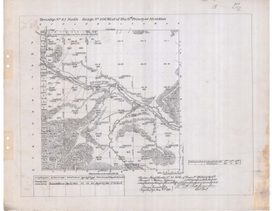
Survey Map Township 41, Range 106, Sections 1 - 36
Date
1892
Description
Survey Map by Wm A. Richards, surveyed by Carpenter & Warner, US Surveyor General's Office, Township 41, Range 106, Sections 1 - 36, includes topo info, Big Wind River, roads, ditch, creeks, date of contract, amount of survey, survey dates, magnetic declination, 1 set with 1 sheet negative paper
Category - Type
Map-Survey
Title
Reduced Fort Bridger Military Reservation Survey Map Township 15 Range 115, Sections 27 - 34, Township 16, Range 115, Sections 3 - 5, 8 - 10, 15 - 17, 20 - 22
Date
1892
Description
Reduced Fort Bridger Military Reservation Survey Map by Wm A. Richards, surveyed by WM Gilcrest, US Surveyor General's Office, Township 15 , Range 115, Sections 27 - 34, Township 16, Range 115, Sections 3 - 5, 8 - 10, 15 - 17, 20 - 22, includes topo info, roads, ditch, National Cemetery, Carter, Sage Flat, Tank & Pumphouse, store, telephone line, total number of acres, dates of contracts, amount of surveys, magnetic declination, 1 set with 1 sheet negative paper
Category - Type
Map-Survey
1-2 of 2
|