|
REFINE
Browse All : Map-Survey and Still Image from 1893
1-9 of 9
Title
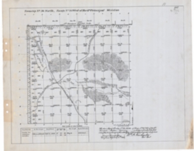
Survey Map Township 33, Range 90, Sections 1 - 36
Date
1893
Description
Survey Map by Wm A. Richards, surveyed by Coleman & Gilcrest, US Surveyor General's Office, printed-A Gast & Co, Township 33, Range 90, Sections 1 - 36, includes topo info, Ervay to Muskrat Road, roads, Clay City Ruins, Sarcophegas Buttes, Willow Creek, Salt Sage Flat, Oil Prospect Holes, Sand Rock Point, creeks, total number of acres, dates of contracts, amount of surveys, magnetic declination, 1 set with 1 sheet negative paper
Category - Type
Map-Survey
Title
Survey Map Township 34, Range 90, Sections 1 - 36
Date
1893
Description
Survey Map by Wm A. Richards, surveyed by Coleman & Gilcrest, US Surveyor General's Office, printed-A Gast & Co, Township 34, Range 90, Sections 1 - 36, includes topo info, Casper to Lander Road, Indian Beer Garden, Sandstone Bluff, Pictured Rock, Salt Sage Flat, Oil Prospect Holes, sandstone ledge, creeks, total number of acres, dates of contracts, amount of surveys, magnetic declination, 2 sets with 1 sheet negative paper
Category - Type
Map-Survey
Title
Survey Map Township 35, Range 91, Sections 1 - 36
Date
1893
Description
Survey Map by Wm A. Richards, surveyed-Coleman & Gilcrest, US Surveyor General's Office, printed-A Gast & Co, Township 35, Range 91, Sections 1 - 36, includes Lost Cabin to Rongis Road, Muskrat to Slough Springs Road, 71 Horse Ranch to Rongis Road, meadow topo info, creeks, total number of acres, dates of contracts, amount of surveys, magnetic declination, No. 4564, 1 set with 1 sheet positive paper
Category - Type
Map-Survey
Title
Survey Map Township 36 Range 94, Sections 1 - 36
Date
1893
Description
Survey Map by Wm A. Richards, surveyed by Coleman & Gilcrest, US Surveyor General's Office, Township 36, Range 94, Sections 1 - 36, includes topo info, roads, creeks, total number of acres, dates of contracts, amount of surveys, magnetic declination, 1 set with 1 sheet paper
Category - Type
Map-Survey
Title
Survey Map Township 41, Range 107, Sections 1 - 4 9 -10
Date
1893
Description
Survey Map by Wm A. Richards, surveyed by Carpenter & Warner, US Surveyor General's Office, Township 41, Range 107, Sections 1 - 4 , 9 -10, includes topo info, ditches, trails, creeks,rivers, total number of acres, dates of contracts, amount of surveys, , 1 set with 1 sheet paper
Category - Type
Map-Survey
Title
Survey Map Township 42, Range 109, Sections 1 - 36
Date
1893
Description
Survey Map by Wm A. Richards, surveyed by Carpenter & Warner, US Surveyor General's Office, Township 42, Range 109, Sections 1 - 36, includes topo info, roads, creeks, Continental Divide, total number of acres, dates of contracts, amount of surveys, magnetic declination, Accession No. 4510, 2611, 1 set with 1 sheet negative paper
Category - Type
Map-Survey
Title
Survey Map Township 42, Range 110, Sections 1 - 36
Date
1893
Description
Survey Map by Wm A. Richards, surveyed by Carpenter & Warner, US Surveyor General's Office, Township 42, Range 110, Sections 1 - 36, includes topo info, roads, creeks, Continental Divide, total number of acres, dates of contracts, amount of surveys, magnetic declination, Accession No. 4510, 2611, 1 set with 1 sheet negative paper
Category - Type
Map-Survey
Title
Survey Map Township 43, Range 110, Sections 1 - 36
Date
1893
Description
Survey Map by Wm A. Richards, surveyed by Carpenter & Warner, US Surveyor General's Office, Township 43, Range 110, Sections 1 - 36, includes topo info, roads, creeks, Continental Divide, total number of acres, dates of contracts, amount of surveys, magnetic declination, Accession No. 4510, 2611, 1 set with 1 sheet negative paper
Category - Type
Map-Survey
Title
Survey Map Township 44, Range 94, Sections 1 - 36
Date
1893
Description
Survey Map by Wm A. Richards, surveyed by Carpenter & Warner, US Surveyor General's Office, printed-A Gast & Co, Township 44, Range 94, Sections 1 - 36, includes , Big Horn River, stock corral, roads, topo info, creeks, total number of acres, dates of contracts, amount of surveys, magnetic declination, 2 sets-1 set with 1 sheet positive paper & 1 set with 1 sheet blueprint
Category - Type
Map-Survey
1-9 of 9
|