|
REFINE
Browse All : Map-Survey of 1608 and 1 from 1900
1-1 of 1
Title
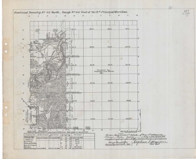
Survey Map Township 43, Range 94, Sections 5, 7 -8, 17 - 20, 29 - 32
Date
1900
Description
Survey Map by Alpheus P. Hanson, surveyed-Edward F. Stahle, Frank S. Wood, US Surveyor General's Office, printed-The Norris Peters Co., Township 43, Range 94, Sections 5, 7 -8, 17 - 20, 29 - 32, includes Old East Shoshone Indian Reservation Boundary, Road to Casper, roads, ditches, topo info, Big Horn River, principal spirng, creeks, total number of acres, date of contracts, amount of surveys, No. 1970, 2 sets with 1 sheet negative paper
Category - Type
Map-Survey
1-1 of 1
|