|
Title
Colter route map
Date
1814
Description
Colter route - English map, paper
Category - Type
Map-Trail or Road
Title
Lewis & Clark's track? Map
Date
[1814, 1804, 1805, 1806]
Description
Map Lewis & Clark's track?, 1804, 1805, 1806
Category - Type
Map-Trail or Road
Title
Lewis and Clark map
Date
1814
Description
Lewis and Clark - American edition, paper
Category - Type
Map-Trail or Road
Title
Lewis and Clark map
Date
1814
Description
Lewis and Clark - English edition, paper
Category - Type
Map-Trail or Road
Title
Western Trails Digitization Project Trail Records
Date
[1840 circa, 2005]
Description
Western Trails Digitization Project, 8/12/3005, acces & thumbnail scans, includes scans & corresponding metadata of Trail Records from all WY Dept of State Parks & Cultural Resources Programs (DUPLICATE ENTRY)
Category - Type
Map-Trail or Road
Title
Explorations for Rail Route from the Mississippi to the Pacific Ocean
Date
1846
Description
Exploring Expedition to the Rocky Mountains in 1842, OR & North CA in 1843-1844 by JC Fremont includes expedition route, profile of route, mountains, Indian tribe locations, rivers, ocean, oversized, paper
Category - Type
Map-Trail or Road
Title
Fremont Expedition Topographical Map of the Road from Missouri to Oregon
Date
1846
Description
Fremont Expedition Topographical Map of the Road from Missouri to Oregon commencing at the mouth of the Kansas in the Missouri River and ending at the mouth of the Wallah Wallah in the Columbia in 7 sections by Charles Pruess from the field notes & journal of Capt JC Fremont, includes longitude, latitude, rivers, creeks, cities, towns, Indian regions, regional remarks, 4 sets 7 maps (1 reversed, 2 negative) 2 sets, 7 sheets blueprints
Category - Type
Map-Trail or Road
Title
Emigrant Road from Independence , Missouri to San Francisco, California map
Date
1848
Description
Map Emigrant Road from Independence , Missouri to San Francisco, California 20 sheets
Category - Type
Map-Trail or Road
Title
Fort Leavenworth to the Great Salt Lake Route
Date
1850
Description
Map of Route from Fort Leavenworth to the Great Salt Lake. State border, the North Platte River, the South Pllatte River and the Great Salt Lake are highlighted
Category - Type
Map-Trail or Road
Title
Fort Leavenworth to the Great Salt Lake route
Date
1850
Description
Map of Route from Fort Leavenworth to the Great Salt Lake reverse positive
Category - Type
Map-Trail or Road
Title
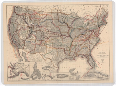
Explorations & Surveys for a Railroad Route from the Mississippi River to the Pacific Ocean
Date
1855
Description
Explorations & Surveys for a Railroad Route from the Mississippi River to the Pacific Ocean, War Department, Map No. 3-From the Santa Fe Crossing to the Choo-Che-To-Pa Pass by Capt JW Gunnison, assisted by Capt EG Beckwith, topographer for the route- FW Eglostein, scanned from Wyoming State Library Book Y1.1/2:801
Category - Type
Map-Trail or Road
Title
Survey Possible Route for Railroad from Mississippi to California
Date
1855
Description
Survey Possible Route for Railroad from Mississippi to California Map #3 & Map #4
Category - Type
Map-Trail or Road
Title
Judge WA Carter and Party route taken Fall 1857
Date
1857 Circa
Description
Route of Judge W A Carter and Party taken Fall 1857, 1 set with 1 sheet vellum
Category - Type
Map-Trail or Road
Title
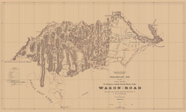
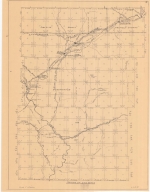
Fort Kearney, South Pass, and Honey Lake Wagon Road Preliminary Map (Lander's Cut-off)
Date
1857-1858
Description
Fort Kearney, South Pass, and Honey Lake Wagon Road Preliminary Map (Lander's Cut-off) 1857-by FW Lander and WH Wagner, includes roads, rivers, creeks, passes, gaps, railroads, cities, towns, mountains, photostatic copy
Category - Type
Map-Trail or Road
Title
Fort Kearney, South Pass, and Honey Lake Wagon Road Preliminary Map (Lander's Cut-off)
Date
1857-1858
Description
Fort Kearney, South Pass, and Honey Lake Wagon Road Preliminary Map (Lander's Cut-off) 1857-by FW Lander and WH Wagner, includes roads, rivers, creeks, passes, gaps, railroads, cities, towns, mountains 2 copies, paper
Category - Type
Map-Trail or Road
Title
Fort Kearney, South Pass, and Honey Lake Wagon Road Preliminary Map (Lander's Cut-off)
Date
1857-1858
Description
Fort Kearney, South Pass, and Honey Lake Wagon Road Preliminary Map (Lander's Cut-off) 1857-by FW Lander and WH Wagner, includes roads, rivers, creeks, passes, gaps, railroads, cities, towns, mountains, 3 copies, paper
Category - Type
Map-Trail or Road
Title
Fort Kearney, South Pass, and Honey Lake Wagon Road Preliminary Map (Lander's Cut-off)
Date
1858
Description
Preliminary map Fort Kearney Wagon Road, 1857-1858 4 copies
Category - Type
Map-Trail or Road
Title
Fort Laramie to Great Salt Lake Map
Date
1858
Description
Map Fort Laramie to Great Salt Lake from the explorations by JC Fremont, H Stansbury, EG Beckwith, Fort Bryan, FW Lander, drawn by E Freyhold, litho of E Freyhold, 2nd edition with corrections and additions from map prepared by Major EJ Porter, includes forts, cities, towns, rivers, creeks, mountains, hills, routes, regional remarks
Category - Type
Map-Trail or Road
Title
Guide Map Great Texas Cattle Trail
Date
1874
Description
Guide Map Great Texas Cattle Trail booklet and map
Category - Type
Map-Trail or Road
Title
Albany County Map, plat of County road from Laramie to Fort Fetterman
Date
1890
Description
Albany County Map, plat of County road from Laramie to Fort Fetterman, includes township, range, County roads, stage routes, rivers, creeks, lakes, towns, railroads Xerox copy
Category - Type
Map-Trail or Road
Title
Laramie to Fort Fetterman County Road plat
Date
1890
Description
Plat of the County Road from Laramie to Fort Fetterman by W.O. Owen, includes townships, ranges, sections, roads, cities & towns, rivers & creeks, lakes, railroads, 2 incomplete copies, 1 is a postive print, the other is negative (Cross Reference Entry)
Category - Type
Map-Trail or Road
Title
United States Map, showing principle explorers
Date
1908
Description
Map US, showing principle explorers
Category - Type
Map-Trail or Road
Title
Yellowstone Trail Map
Date
1912
Description
Map Yellowstone Trail
Category - Type
Map-Trail or Road
Title
Yellowstone Trail Map
Date
1912
Description
Map Yellowstone Trail
Category - Type
Map-Trail or Road
Title
Wyoming State Map
Date
1927-1953
Description
WY State Map by US Geological Survey, includes townships and ranges, counties, cities & towns, rivers & creeks, highways. Paul Henderson, State Park Historian annotated the map to include trails, stage stations, camps, forts, ranches, state parks & Hunt's Route in 1811. 1 set with 1 sheet oversized color-coded paper
Category - Type
Map-Trail or Road
Title
Glenrock area trail map
Date
1933
Description
Glenrock area trail map by LC Bishop, data by EB Shaffner, IG Phillips, includes townships, ranges, sections, creek, road, river, creek, ditch, trail, ranch, graves, mine, historic sites, 2 blueprint, 2 Xeroxes
Category - Type
Map-Trail or Road
Title
Pony Express Trail Map
Date
1935
Description
Pony Express Trail Map by Gerald Harrington blueprint
Category - Type
Map-Trail or Road
Title
Historic Trails of Wyoming map
Date
1940 Circa
Description
Map Historic Trails of Wyoming includes counties, trail indicators, 4 copies, 1 vellum, 3 paper (same as map 212)
Category - Type
Map-Trail or Road
Title
Roads in Pioneer Days & the Roads Roundups hand drawn map
Date
1941
Description
Hand drawn map of Roads in Pioneer Days & the Roads Roundups Used, by AS Gillispie, includes Converse County, Natrona County, Goshen County, Platte County, Laramie County, Albany County and Carbon County
Category - Type
Map-Trail or Road
Title
Oregon Trail from the 8/15/1943 Oregonian
Date
1943
Description
Map Oregon Trail from the 8/15/1943 Oregonian
Category - Type
Map-Trail or Road
Title
The Trail of Lewis & Clark, 1804-1806
Date
1945
Description
Map The Trail of Lewis & Clark, 1804-1806
Category - Type
Map-Trail or Road
Title
Mormon Trail Map
Date
1947
Description
Mormon Trail Map by American Pioneer Trails Assn, printed by The Clarke Press, J Rulon Hales, includes trails, sites, western drawings, brief history, colored (pictorial map), paper, colored
Category - Type
Map-Trail or Road
Title
Old Oregon Trail map
Date
1948
Description
Map Old Oregon Trail
Category - Type
Map-Trail or Road
Title
America's Cattle Trails, United States map
Date
1949
Description
US Map, America's Cattle Trails by the Western Range Cattle Industry Study and the American Pioneer Trails Assn, compiled by Garnet Brayer and Herbert Brayer, Hugh Glen cartographer, C.O. Froid illustrator includes cattle trails, states, cities, forts, railroads, continental divide, rivers, drawings of ship, brands, roundup scenes, cattle, index to trails, colored, 4 copies, paper
Category - Type
Map-Trail or Road
Title
Southwest Wyoming Map Townships 117 - 120, Ranges 14 - 15
Date
1951
Description
South West Wyoming Map, sheet 206 by Paul Henderson, WY State Parks Commission, includes trails and roads, historic sites, Townships 117 - 120, Ranges 14 - 15
Category - Type
Map-Trail or Road
Title
Oregon Trail Map
Date
1952
Description
Map Oregon Trail, 1852
Category - Type
Map-Trail or Road
Title
Park County Road Map (portion of Co)
Date
1955 Circa
Description
Park County Road Map (portion of Co) includes Meeteetse Cody Road, Convict Road, Old Dodge Road, Dry Creek Stage Station & Arland
Category - Type
Map-Trail or Road
Title
Parting of the Ways Map
Date
1958
Description
Parting of the Ways Map by LC Bishop, includes townships, ranges, rivers, creeks, roads, trails, pony express stations, stage stations, graves, 2 copies
Category - Type
Map-Trail or Road
Title
California-Oregon-Mormon Emigrant Roads Maps
Date
1959
Description
Map of California-Oregon-Mormon Emigrant Roads
Category - Type
Map-Trail or Road
Title
California-Oregon-Mormon-Emigrant Roads map
Date
1959
Description
Map California-Oregon-Mormon-Emigrant Roads featuring the Pony Express, 1860-1861, by LC Bishop & Paul Henderson, includes cities, towns, rivers, creeks, state boundaries, stage stations, drawing of saddle & machila, 9 blueline paper copies
Category - Type
Map-Trail or Road
Title
Parting of the Ways Map
Date
1959
Description
03 Parting of the Ways Map by LC Bishop, includes townships, ranges, rivers, creeks, roads, trails, pony express stations, stage stations, graves, 1 sheet vellum, 4 paper copies
Category - Type
Map-Trail or Road
|