|
REFINE
Browse All : Still Image and Map-City/Casper of Casper and 1
1-6 of 6
Title
Casper Zoning Map
Date
1904
Description
Casper Map, includes lots & blocks, streets & avenues, North Platte River, railroad tracks, Depot Grounds-Wyoming Central Railway, 1 set with 1 sheet blueprint
Category - Type
Map-City/Casper
Title
Casper Plat
Date
1922
Description
Casper Plat by Casper City Engineering Dept includes lots, blocks, streets, railroad, river, refineries, portion of map color coded-with no explanation 1 vellum
Category - Type
Map-City/Casper
Title
Casper Map
Date
1940
Description
Casper Map includes streets, cemetery, railroad, river, parks, highway Vellum
Category - Type
Map-City/Casper
Title
Casper city map and environs
Date
Undated
Description
Casper city map and environs, includes public buildings, points of interest, recreational areas & facilities, school index, advertisers index, North Platte River, railroad lines, small map of State with-counties, highways, cities, geographic locations, State lines, Wardwell Extension & Bar Nunn, Airport Extension. Double sided.
Category - Type
Map-City/Casper
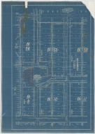
Title
Casper Plat includes blocks 54 through 56, Blocks 9 though 10
Date
Undated
Description
Casper Plat includes blocks 54 through 56, Blocks 9 though 10, corresponding lots, Market to North Wolcott, West G to Firs; location of courthouse, CB & Q depot, drawing of building across from courthouse (West B Street), storm sewer info, 1 Blueprint
Category - Type
Map-City/Casper
1-6 of 6
|