|
Title
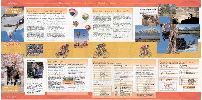
Wyoming Highway Map
Date
2005
Description
WY Highway Map, includes Highways, State Parks, graded and earth roads, info centers, points of interest, rest areas, intermittent streams county seats, railroads, rivers & streams, scenic byways, National Forests & Grasslands, National Park Service areas historic trails, map scale, map relief, cities & towns, city enlargements, Wyoming city & town index, mileage chart. Reverse: safety message, State & National recreation site listings, general recreation info. 3 sets with 1 sheet paper
Category - Type
Map-State
Title
Wyoming Highway Map
Date
2006
Description
WY Highway Map by Public Affairs Office of the WY Transportation Department includes highways & interstates, city map blow-ups, mountain ranges, roads, county boundaries, rivers & streams, lakes & reservoirs, location names, historic descriptions, railroads, historic trails, legend & index, statewide recreation site listings by agency administrator, general tourist info, road & weather condition access info, 3 sets with 1 double-sided colored paper
Category - Type
Map-State
Title
Wyoming Map
Date
Undated
Description
WY Map by Works Projects Administration (WPA),, paper
Category - Type
Map-State
Title
Wyoming Map
Date
Undated
Description
WY Map by US Dept of Interior Geological Survey includes townships, ranges, counties, cities, towns, highways & interstates 1 reverse positive
Category - Type
Map-State
Title
Wyoming Resources Map
Date
1911 Circa
Description
Map of WY Resources by WY State Board of Immigration Clason Map Co., includes mineral resources, agricultural land, townships, ranges, railroads, roads, trails, national forests, US Land districts, index for mountains, rivers, creeks, cities, towns Stimson photos, descripitve info re. Wyoming, Tables-what you can make on 80 acres & annual profit
Category - Type
Map-State
Title
Clason's Industrial Map of Wyoming
Date
1913 Circa
Description
Clason's Industrial Map of WY by Classon Map Co. copyrighted 1911 includes mineral resources, agricultural land, townships, ranges, railroads, roads, trails, national forests, US Land districts, index for mountains, rivers, creeks, cities, towns
Category - Type
Map-State
Title
Wyoming Resources Map
Date
1942
Description
WY Resources Map by WY Dept of Commerce & Industry from US Geological Survey base map includes townships, ranges, rivers, creeks, oil & gas fields, mineral locations, airfields, cities, towns, forests, counties, lakes, gas lines, paper, color coded 1 sheet paper-negative
Category - Type
Map-State
Title
Wyoming Resources Map
Date
1942
Description
WY Resources Map by WY Dept of Commerce & Industry from US Geological Survey base map includes townships, ranges, rivers, creeks, oil and gas fields, mineral locations, airfields, cities, towns, forests, counties, lakes, gas lines, paper, color coded
Category - Type
Map-State
Title
Wyoming Mines & Minerals Map
Date
1979
Description
WY Mines & Minerals Map by WY Geological Survey, Dan Hausel, Gary Glass, David Lageson, Alan VerPloeg, Rodney DeBruin, includes mineral types, regions, mines, quarries, bentonite mills, coal fields, national forest, mountains, highways, 1 set with 1 color-coded sheet paper
Category - Type
Map-State
Title
Wyoming Highway Map
Date
1933
Description
Highway Map by WY State Highway Dept, 3 copies, Index of Federal Aid Projects (FAPs), historic state transportation improvement projects (STIP)
Category - Type
Map-State
Title
Wyoming Highway Map
Date
1933
Description
Highway Map by WY State Highway Dept, 3 copies, Index of Federal Aid Projects (FAPs), historic state transportation improvement projects (STIP)
Category - Type
Map-State
Title
Johnson's Nebraska, Dakota, Idaho, Montana & Wyoming Map
Date
1875 Circa
Description
Johnson's Nebraska, Dakota, Idaho, Montana & WY Map includes north Colorado, Kansas & Utah; northeast Nevada;east Washington & Oregon, west Minnesota & Iowa, cities, towns, rivers, railroads, Pease County pages 76, 77, colored map
Category - Type
Map-State
|