|
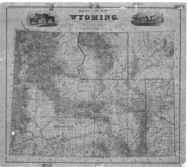
Title
Holts New Map of Wyoming
Date
1890 Circa
Description
Holts New Map of WY (mislabeled 1883) includes cities, towns, rivers, creeks, mountains, railroads, roads, forts, mining districts, 20 mile limit (cannot copy)
Category - Type
Map-State
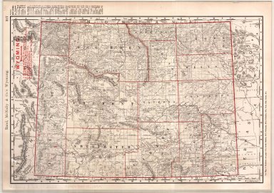
Title
Wyoming Map
Date
1890 Circa
Description
WY Map includes counties, cities, townships, ranges, creeks, Indian Reservation, National Park, mountains, rivers & creeks, mining districts, ranches, index-on back, 1 set with 1 sheet colored paper
Category - Type
Map-State
Title
Wyoming Map
Date
1892
Description
WY Map by US Dept of Interior, General Land Office includes surveyor general's office, US Land offices, townships, ranges, incomplete railroads, stage stations, 1 sheet colored linen backed paper
Category - Type
Map-State
Title
Wyoming Map
Date
1892
Description
WY Map by US Dept of Interior, General Land Office includes surveyor general's office, US Land offices, townships, ranges, incomplete railroads, stage stations, 1 sheet colored linen backed paper
Category - Type
Map-State
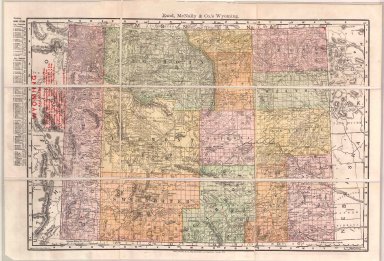
Title
Atlas of the World byRand, McNally & Co, includes Wyoming
Date
1895
Description
Rand, McNally & CO's Indexed Atlas of the World, Map of WY copyrighted 1895 includes town index-on side, the 4 major railroads have are highlighted with red numbers, townships, ranges pages 317, 318 1 color coded sheet paper and 1 copy
Category - Type
Map-State
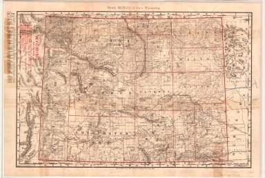
Title
Wyoming Map
Date
1895
Description
WY Map by Rand McNally
Category - Type
Map-State
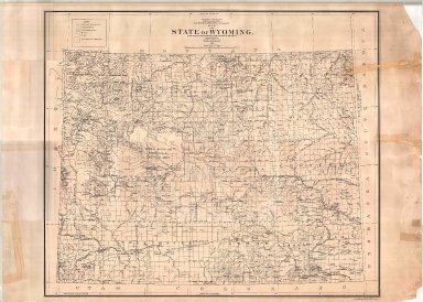
Title
Wyoming Map
Date
1900
Description
WY Map by US Dept of Interior, General Land Office includes surveyor general's office, US Land offices, townships, ranges, Indian reservations, military reservations, forest reserves 3 copies ( 1 reverse positive)-not colored map?
Category - Type
Map-State
Title
Wyoming Map
Date
1900
Description
WY Map by US Dept of Interior, General Land Office includes surveyor general's office, US Land offices, townships, ranges, Water Divisions & Districts, Indian reservations, military reservations, forest reserves, 1 linen backed paper copy
Category - Type
Map-State
Title
Wyoming Map
Date
1900
Description
WY Map by US Dept of Interior, General Land Office includes surveyor general's office, US Land offices, townships, ranges, Indian reservations, military reservations, forest reserves, 2 copies
Category - Type
Map-State
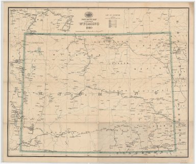
Title
Post Route Map of the States of Montana, Idaho & Wyoming
Date
1903
Description
Post Route Map of the States of Montana, Idaho & WY, by Postmaster General Henry C. Payne, under direction of A. VonHaake, includes East Oregon & Washington, Northeast Utah, West North Dakota, South Dakota & Nebraska, extreme North Colorado, index to counties, designations for: railroads, frequency of mail service, post offices, cities, towns, counties, 1 set colored paper with 2 pages
Category - Type
Map-State
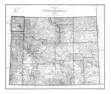
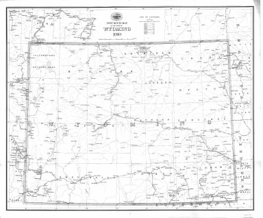
Title
Wyoming Map
Date
1905
Description
WY Map by US Dept of Interior includes US surveyor general's office, US land offices, townships, ranges, Indian reservations, military reservations, forest reserves, national parks & monuments, bird reserves, land district boundaries
Category - Type
Map-State
Title
Wyoming Map
Date
1906
Description
WY Map by Kenyon Printing & Manufacturing Co. copyrighted in 1906 by George F Cram index to towns, counties and railroads on back, Stockgrowers National Bank stamped on front Xerox copy. Map includes townships & ranges, counties, cities & towns, railroads, mountains & hills, rivers and lakes, 1 set with 1 sheet xerox paper
Category - Type
Map-State
Title
Wyoming Map
Date
1907
Description
WY Map by US Dept of Interior includes US surveyor general's office, US land offices, townships, ranges, Indian reservations, military reservations, forest reserves, national parks & monuments, bird reserves, land district boundaries 3 copies
Category - Type
Map-State
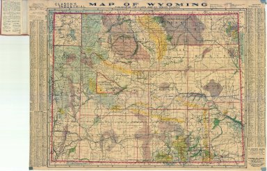
Title
Clason's Industrial Map of Wyoming
Date
1908
Description
Clason's Industrial Map of WY includes townships, ranges, counties, cities, rivers, creeks, coal fields, wagon roads, irrigated lands, city & town index, mineral deposits national forests, 1 copy
Category - Type
Map-State
Title
Atlas of the World byRand, McNally & Co, includes Wyoming
Date
1910
Description
Rand, McNally & CO's Indexed Atlas of the World, Map of WY copyrighted 1910 & 1895 includes townships, ranges, counties, cities & towns, mountains, lakes, railroads, 1 sheet color page
Category - Type
Map-State
Title
Post Route Map of Wyoming
Date
1910
Description
Post Route Map of WY by the US Postal Service
Category - Type
Map-State
Title
Post Route Map of Wyoming
Date
1910
Description
Post Route Map of WY by the US Postal Service
Category - Type
Map-State
Title
Clason's Guide Map of Wyoming
Date
1911
Description
Clason's Guide Map of WY includes townships, ranges, counties, cities, rivers, creeks (Note: shows Hannover County) 2 copies (1 negative copy)
Category - Type
Map-State
Title
Clason's Guide Map of Wyoming
Date
1911
Description
Clason's Guide Map of WY includes townships, ranges, counties, cities, rivers, creeks (Note: shows Hannover County) 2 copies (1 negative copy)
Category - Type
Map-State
Title
Clason's Industrial Map of Wyoming
Date
1911
Description
Clason's Industrial Map of WY includes townships, ranges, counties, cities, rivers, creeks, coal fields, wagon roads, irrigated lands, city & town index, mineral deposits national forests, 3 copies (1 negative copy)
Category - Type
Map-State
Title
Post Route Map of Wyoming
Date
1912
Description
Post Route Map of WY by the US Postal Service
Category - Type
Map-State
Title
Post Route Map of Wyoming
Date
1912
Description
Post Route Map of WY by the US Postal Service
Category - Type
Map-State
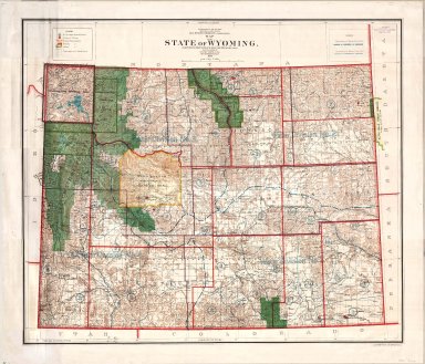
Title
Wyoming Map
Date
1912
Description
WY Map by the US Dept of Interior includes US surveyor general's office, US Land offices, townships, ranges, Indian reservations, military reservations, forest reserves, national parks & monuments, bird reserves, land district boundaries, colored paper, 2 copies
Category - Type
Map-State
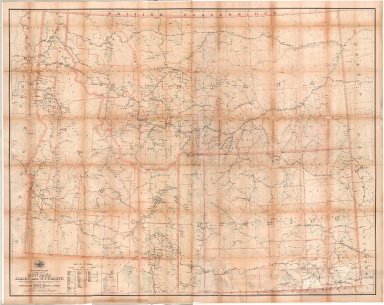
Title
Wyoming Map
Date
1913
Description
WY map showing petroleum withdrawals outstanding on 9/30/1916. Map includes state line, latitude & longitude, counties with boundries & townships, federal reservations, river courses, towns, Indian Reservation.
Category - Type
Map-State
Title
Clason's Industrial Map of Wyoming
Date
1914
Description
Clason's Industrial Map of WY by Classon Map Co. copyrighted 1911 includes mineral resources, agricultural land, townships, ranges, railroads, roads, trails, national forests, US Land districts, index for mountains, peaks, rivers, creeks, cities, towns
Category - Type
Map-State
Title
Wyoming Map
Date
1915
Description
WY Map by Pubic Service Commission, Robert Forsyth, Herman B. Gates, HA Floyd, includes townships, ranges, counties, cities, towns, roads, highways, railroads, rivers, creeks, forests, population statistics
Category - Type
Map-State
Title
Clason's Guide Map of Wyoming
Date
1916
Description
Clason's Guide Map of WY includes index
Category - Type
Map-State
Title
Wyoming Map
Date
1916
Description
WY Map by US Geological Survey, IP Berthrong, includes townships, ranges, cities, towns, counties, index to gauging stations, principal drainage basin boundaries, railroads, national forests, mountains, rivers, creeks, US Land Offices, 1 sheet linen backed colored paper
Category - Type
Map-State
Title
Wyoming Map
Date
1916
Description
WY Map by US Department of Interior, IP Berthrong, includes townships, ranges, cities, towns, counties, railroads, national forests, mountains, rivers, creeks, US Land Offices, colored
Category - Type
Map-State
Title
Wyoming Map
Date
1916
Description
WY Map by the US Geological Society includes gauging stations, lands with irrigated water rights, surface waters, plate 1 from the office of the state engineer
Category - Type
Map-State
Title
Lands designated by the Secretary of Interior under the provision of the enlarged homestead acts
Date
1918
Description
Lands designated by the Secretary of Interior under the provision of the enlarged homestead acts by the Dept of Interior includes US surveyor general's office, US Land offices, Land districts, townships, ranges
Category - Type
Map-State
Title
Railroad Map of Wyoming
Date
1918
Description
Railroad Map of WY by Classon Map Co, for the public service commission includes cities, towns, townships, ranges, rivers, creeks, railroads, roads, highways, index to cities, towns with population figures, national forests, paper, colored, 2 copies
Category - Type
Map-State
Title
State Highway System Wyoming
Date
1918
Description
System of state highways by highway commission index includes highways to be built, highways graded, ungraded, forest aid roads, index
Category - Type
Map-State
Title
State Highway System Wyoming
Date
1918
Description
System of state highways by highway commission index includes highways to be built, highways graded, ungraded, forest aid roads, index
Category - Type
Map-State
Title
Clason's Guide Map of Wyoming
Date
1919
Description
Clason's Guide Map of WY includes townships, ranges, oil & gas fields, index. Principal auto roads are shown in red, oil and gas fields are shown in orange-which looks yellow(second copy of map-attached to Clason's Road Map & Railway Guide in collection B-11)
Category - Type
Map-State
Title
New Commercial Atlas Map of Wyoming by Rand, McNally & Co
Date
1920 Circa
Description
Rand, McNally's New Commercial Atlas Map of WY includes road map on back, index cities, towns, townships, ranges, rivers, creeks, railroads, index to railroads
Category - Type
Map-State
Title
New Commercial Atlas Map of Wyoming by Rand, McNally & Co
Date
1920 Circa
Description
Rand, McNally's New Commercial Atlas Map of WY includes road map on back, index cities, towns, townships, ranges, rivers, creeks, railroads, index to railroads
Category - Type
Map-State
Title
New Commercial Atlas Map of Wyoming by Rand, McNally & Co
Date
1920 Circa
Description
Rand, McNally's New Commercial Atlas Map of WY includes road map on back, index cities, towns, townships, ranges, rivers, creeks, railroads, index to railroads
Category - Type
Map-State
Title
Wyoming Map by National Map Co.
Date
1923 Circa
Description
National Map CO's Map of WY includes townships, ranges, national transportation routes, detailed index
Category - Type
Map-State
Title
Wyoming Standard Map by Rand, McNally & Co
Date
1923 Circa
Description
Rand, McNally's Standard Map of WY includes townships, ranges, road map on back, index
Category - Type
Map-State
Title
Wyoming Standard Map by Rand, McNally & Co
Date
1923 Circa
Description
Rand, McNally's Standard Map of WY includes townships, ranges, road map on back, index
Category - Type
Map-State
Title
Wyoming Highway Map
Date
1924
Description
Highway Map of WY by Casper Star Tribune includes points of interest list, mileage chart, printed photograph of Casper, oil fields on newsprint
Category - Type
Map-State
|