|
REFINE
Browse All : Still Image and Map-Survey from 1883
1-23 of 23
Title
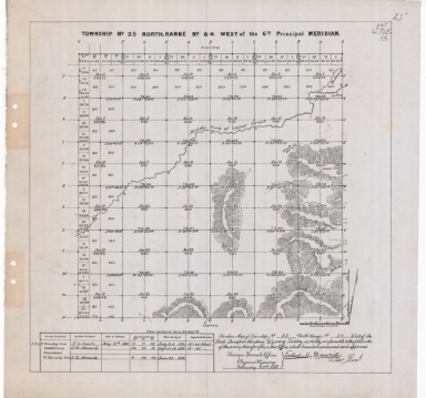
Survey Map Township 33, Range 79, Sections 1 - 36
Date
1883
Description
Survey Map by Edw. C David, surveyed by Wm O. Owen, Downey & Grant, US Surveyor General's Office, printed-A Gast & Co, Township 33, Range 79, Sections 1 - 36, includes topo info, North Platte River, roads, creeks, total number of acres, dates of contracts , amount of surveys, magnetic declination, No. 2026, 1 set with 1 sheet negative paper
Category - Type
Map-Survey
Title
Survey Map Township 33, Range 80, Sections 1 - 36
Date
1883
Description
Survey Map by Edw. C David, surveyed by Wm O. Owen, Downey & Grant, US Surveyor General's Office, printed-A Gast & Co, Township 33, Range 80, Sections 1 - 36, includes topo info, North Platte River, ranch, roads, creeks, total number of acres, dates of contracts, amount of surveys, magnetic declination, set with 1 sheet paper
Category - Type
Map-Survey
Title
Survey Map Township 34, Range 79, Sections 1 - 36
Date
1883
Description
Survey Map by Edw. C David, surveyed by Wm O. Owen, US Surveyor General's Office, printed-A Gast & Co, Township 34, Range 79, Sections 1 - 36, includes North Platte River, creeks, roads, dry lakes, total number of acres, amount of surveys, magnetic declination, No. 2027, 76 1 set with 1 sheet negative paper
Category - Type
Map-Survey
Title
Survey Map Township 35, Range 80, Sections 1 - 36
Date
1883
Description
Survey Map by Edw. C. David, surveyed by Wm O Owen, JB Shelby, Downey & Grant, US Surveyor General's Office, printed-A Gast & Co, Township 35, Range 80, Sections 1 - 36, includes topo info, roads, creeks, total number of acres, date of contracts, amount of surveys, 1 set with 1 sheet paper
Category - Type
Map-Survey
Title
Survey Map Township 35, Range 81, Sections 1 - 36
Date
1883
Description
Survey Map by Edw. C. David, surveyed by FO Sawin, JB Menardi, Downey & Grant, US Surveyor General's Office, printed-A Gast & Co, Township 35, Range 81, Sections 1 - 36, includes topo info, roads, creeks, total number of acres, date of contracts, amount of surveys, 1 set with 1 sheet paper
Category - Type
Map-Survey
Title
Survey Map Township 35, Range 84, Sections 1 - 36
Date
1883
Description
Survey Map by Edw. C. David, surveyed by FO Sawin, JB Menardi, US Surveyor General's Office, printed-A Gast & Co, Township 35, Range 84, Sections 1 - 36, includes topo info, creeks, bottom land, total number of acres, date of contracts, amount of surveys, No. 1254, 1 set with 1 sheet negative paper
Category - Type
Map-Survey
Title
Survey Map Township 35, Range 86, Sections 1 - 36
Date
1883
Description
Survey Map by Edw. C. David, surveyed by FO Sawin, JB Menardi, US Surveyor General's Office, printed-A Gast & Co, Township 35, Range 86, Sections 1 - 36, includes topo info, creeks, road, total number of acres, date of contracts, amount of surveys, 1 set with 1 sheet paper
Category - Type
Map-Survey
Title
Survey Map Township 35, Range 87, Sections 1 - 36
Date
1883
Description
Survey Map by Edw. C. David, surveyed by FO Sawin, JB Menardi, US Surveyor General's Office, printed-A Gast & Co, Township 35, Range 87, Sections 1 - 36, includes topo info, creeks, total number of acres, date of contracts, amount of surveys, 1 set with 1 sheet paper
Category - Type
Map-Survey
Title
Survey Map Township 36 Range 81, Sections 1 - 36
Date
1883
Description
Survey Map by Edw. C. David, surveyed by FO Sawin, JB Menardi, Downey & Grant, US Surveyor General's Office, printed-A Gast & Co, Township 36, Range 81, Sections 1 - 36, includes topo info, creeks, petrification site, total number of acres, date of contracts, amount of surveys, 1 set with 1 sheet paper
Category - Type
Map-Survey
Title
Survey Map Township 36 Range 82, Sections 1 - 36
Date
1883
Description
Survey Map by Edw. C. David, surveyed by FO Sawin, JB Menardi, US Surveyor General's Office, printed-A Gast & Co, Township 36, Range 82, Sections 1 - 36, includes topo info, Alkali Hills, deposit of bones locations, creeks, total number of acres, date of contracts, amount of surveys, No. 1725, 1247, 1 set with 1 sheet negative paper
Category - Type
Map-Survey
Title
Survey Map Township 36 Range 83, Sections 1 - 36
Date
1883
Description
Survey Map by Edw. C. David, surveyed by FO Sawin, JB Menardi, US Surveyor General's Office, printed-A Gast & Co, Township 36, Range 83, Sections 1 - 36, includes topo info, creeks, fossil stones total number of acres, date of contracts, amount of surveys, 1 set with 1 sheet paper
Category - Type
Map-Survey
Title
Survey Map Township 36 Range 84, Sections 1 - 36
Date
1883
Description
Survey Map by Edw. C. David, surveyed by FO Sawin, JB Menardi, US Surveyor General's Office, printed-A Gast & Co, Township 36, Range 84, Sections 1 - 36, includes topo info, creeks, fossil stones total number of acres, date of contracts, amount of surveys, 1 set with 1 sheet paper
Category - Type
Map-Survey
Title
Survey Map Township 36 Range 85, Sections 1 - 36
Date
1883
Description
Survey Map by Edw. C. David, surveyed by FO Sawin, JB Menardi, US Surveyor General's Office, printed-A Gast & Co, Township 36, Range 85, Sections 1 - 36, includes topo info, South Fork of Powder River, creeks, total number of acres, date of contracts, amount of surveys, 1 set with 1 sheet paper
Category - Type
Map-Survey
Title
Survey Map Township 36 Range 86, Sections 1 - 36
Date
1883
Description
Survey Map by Edw. C. David, surveyed by FO Sawin, JB Menardi, US Surveyor General's Office, printed-A Gast & Co, Township 36, Range 86, Sections 1 - 36, includes topo info, South Fork of Powder River, road, creeks, total number of acres, date of contracts, amount of surveys, 1 set with 1 sheet paper
Category - Type
Map-Survey
Title
Survey Map Township 36 Range 87, Sections 1 - 36
Date
1883
Description
Survey Map by Edw. C. David, surveyed by FO Sawin, JB Menardi, US Surveyor General's Office, printed-A Gast & Co, Township 36, Range 87, Sections 1 - 36, includes topo info, South Fork of Powder River, road, creeks, total number of acres, date of contracts, amount of surveys, 1 set with 1 sheet paper
Category - Type
Map-Survey
Title
Survey Map Township 36 Range 88, Sections 1 - 36
Date
1883
Description
Survey Map by Edw. C. David, surveyed by FO Sawin, JB Menardi, Chas A Honey, US Surveyor General's Office, printed-A Gast & Co, Township 36, Range 88, Sections 1 - 36, includes topo info, creeks, petrification site, total number of acres, date of contracts, amount of surveys, 1 set with 1 sheet paper
Category - Type
Map-Survey
Title
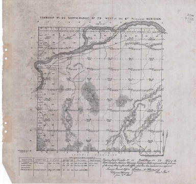
Survey Map Township 22, Range 84, Sections 1 - 36
Date
1883
Description
Survey Map by Edw. C David, US Surveyor General's Office, surveyed by JB Shelby, Thomas B. Medary, printed-A Gast & Co, Township 22, Range 84, Sections 1 - 36, includes topo info, Ferris Ranch to Fort Steele Road, Walcott Station to Ferris Ranch Road, Ferris Ranch to St. Mary's Station Road, North Platte River, creeks, alkali flat, mound of stones, total number of acres, dates of contracts, amount of surveys, magnetic declination, Accession No. 2197. 1 set with 1 sheet negative paper
Category - Type
Map-Survey
Title
Survey Map Township 23, Range 83, Sections 1 - 36
Date
1883
Description
Survey Map by Edw. C David, US Surveyor General's Office, surveyed by JB Shelby, Thomas B. Medary, printed-A Gast & Co, Township 23, Range 83, Sections 1 - 36, includes topo info, Austin's Ranch to Fort Steele Road, creeks, total number of acres, dates of contracts, amount of surveys, magnetic declination, 1 set with 1 sheet negative paper
Category - Type
Map-Survey
Title
Survey Map Township 23, Range 84, Sections 1 - 36
Date
1883
Description
Survey Map by Edw. C David, US Surveyor General's Office, surveyed by JB Shelby, printed-A Gast & Co, Township 23, Range 84, Sections 1 - 36, includes topo info, Semino Mines to Fort Steele Road, Geo Ferne's Ranch, Road to Fort Steele, roads, coal vein, North Platte River, creeks, mound of stones, total number of acres, dates of contracts, amount of surveys, magnetic declination, 1 set with 1 sheet negative paper
Category - Type
Map-Survey
Title
Survey Map Township 23, Range 85, Sections 1 - 36
Date
1883
Description
Survey Map by Edw. C David, US Surveyor General's Office, surveyed by JB Shelby, printed-A Gast & Co, Township 23, Range 85, Sections 1 - 36, includes topo info, O'Brien's Spring to Fort Steele Road, sandstone wall, total number of acres, dates of contracts, amount of surveys, magnetic declination, No. 2201. 1 set with 1 sheet negative paper
Category - Type
Map-Survey
Title
Survey Map Township 24, Range 82, Sections 1 - 36
Date
1883
Description
Survey Map by Edw. C David, US Surveyor General's Office, surveyed by JB Shelby, Downey & Grant, printed-A Gast & Co, Township 24, Range 82, Sections 1 - 36, includes topo info, Chas Smith's ranch, Austin's Ranch to Fort Steele Road, Smith's Ranch to Carbon Road, Austin's Ranch to Benned's Road, Austin's wire fence line, Medicine Bow River, creeks, roads, total number of acres, dates of contracts, amount of surveys, magnetic declination, No. 2194, 1 set with 1 sheet negative paper
Category - Type
Map-Survey
Title
Survey Map Township 24, Range 83, Sections 1 - 36
Date
1883
Description
Survey Map by Edw. C David, US Surveyor General's Office, surveyed by JB Shelby, Downey & Grant, printed-A Gast & Co, Township 24, Range 83, Sections 1 - 36, includes topo info, Fort Steele Road, Medicine Bow River, coal outcropping, creeks, total number of acres, dates of contracts, amount of surveys, magnetic declination, No. 2196, 1 set with 1 sheet negative paper
Category - Type
Map-Survey
1-23 of 23
|