|
REFINE
Browse All : Still Image and Map-Survey of 1094 from 1883
1-1 of 1
Title
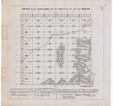
Survey Map Township 35, Range 84, Sections 1 - 36
Date
1883
Description
Survey Map by Edw. C. David, surveyed by FO Sawin, JB Menardi, US Surveyor General's Office, printed-A Gast & Co, Township 35, Range 84, Sections 1 - 36, includes topo info, creeks, bottom land, total number of acres, date of contracts, amount of surveys, No. 1254, 1 set with 1 sheet negative paper
Category - Type
Map-Survey
1-1 of 1
|