|
Title
Fremont Expedition Topographical Map of the Road from Missouri to Oregon
Date
1846
Description
Fremont Expedition Topographical Map of the Road from Missouri to Oregon commencing at the mouth of the Kansas in the Missouri River and ending at the mouth of the Wallah Wallah in the Columbia in 7 sections by Charles Pruess from the field notes & journal of Capt JC Fremont, includes longitude, latitude, rivers, creeks, cities, towns, Indian regions, regional remarks, 4 sets 7 maps (1 reversed, 2 negative) 2 sets, 7 sheets blueprints
Category - Type
Map-Topo
Title
Central Wyoming Map
Date
1877
Description
Part of Central WY Map by US Geological Survey of the Territories, FV Hayden-geologist, George B Chittenden-topo assistant, includes cities & towns, rivers & creeks, basins, hills, sand dunes, portion of Wind River Indian Reservation, mines, wagon roads, lakes, topo info, Map 57, 3 sets, 2 sets with 1 sheet paper, 1 set with 1 sheet colored paper (includes sedimentary formation color-coding, chart)
Category - Type
Map-Topo
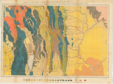
Title
Parts of Western WY, Southeastern Idaho & Northeastern Utah map
Date
1877
Description
Parts of Western WY, Southeastern ID & Northeastern UT map by US Geological & Geographical Survey, FV Hayden, Henry Gannett, includes rivers, creeks, lakes, swamp, roads, mountains, plateaus, railroads, passes, valleys, map 45, 2 sets 1 set with 1 "xerox" copy provided by the National Archives, Perry Jenkins Collection, ACC #388, University of Wyoming Archives; 1 set with 1 sheet paper
Category - Type
Map-Topo
Title
Parts of Western WY, Southeastern Idaho & Northeastern Utah map
Date
1877
Description
Parts of Western WY, Southeastern ID & Northeastern UT map by US Geological & Geographical Survey, FV Hayden, Henry Gannett, described under file 246
Category - Type
Map-Topo
Title
Parts of Western Wyoming, Southeastern Idaho & Northeastern Utah map
Date
1877
Description
Parts of Western WY, Southeastern ID & Northeastern UT map by US Geological & Geographical Survey, FV Hayden, Henry Gannett, includes rivers, creeks, lakes, swamp, roads, mountains, plateaus, railroads, passes, valleys, map 56, 3 sets 1 set with 1 "xerox" copy provided by the National Archives, Perry Jenkins Collection, ACC #388, University of Wyoming Archives; 1 set with 1 sheet colored paper, 1 set with 1 sheet paper
Category - Type
Map-Topo
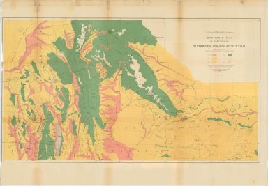
Title
Economic Map of Portions of Wyoming, Idaho & Utah
Date
1879
Description
Economic Map of Portions of WY, ID & UT by US Dept of Interior, US Geological & Geographical Survey of the Territories, FV Hayden, Julius Bien & Co litho, hascolor coding indicating the type of land in the region, cities & towns, mountians, plateaus, basins, rivers & creeks, lakes, topo info, 1 set with 1 sheet colored paper
Category - Type
Map-Topo
Title
Albany County (Laramie Quadrangle) Topographic Map
Date
1903-1908
Description
Albany County (Laramie Quadrangle) Topographic Map 1903, rev 1906, rev 1908 by US Geological Survey, EM Douglas-geographer, Wm Stranahan, TM Bannon & RT Evans-topographers, Frank Tweedy & RH Chapman-surveyors, includes townships, ranges, sections, cities & towns, basins, lakes, rivers & creeks, railroad, ranch names, mountains, 1 incomplete colored map with 1 sheet paper
Category - Type
Map-Topo
Title
Medicine Bow Quadrangle ( County) Topographic Map
Date
1908
Description
Topographic map Medicine Bow Quadrangle ( County)
Category - Type
Map-Topo
Title
Medicine Bow Quadrangle ( County) Topographic Map
Date
1908
Description
Topographic map Medicine Bow Quadrangle ( County)
Category - Type
Map-Topo
Title
Medicine Bow Quadrangle Map
Date
1908
Description
Medicine Bow Quadrangle Map by US Geological Survey Linen
Category - Type
Map-Topo
Title
Colorado Topo Map ranges 69 - 72
Date
1909
Description
Colorado Topo Map by US Geological Survey, includes ranges 69 - 72, townships 6 - 12, rivers & creeks, ranch names, railroad, Medicine Bow National Forest, mountains, bluffs & hills, 1 partial sheet paper-colored
Category - Type
Map-Topo
Title
Colorado Topo Map ranges 69 - 72
Date
1909
Description
Colorado Topo Map by US Geological Survey, includes ranges 69 - 72, townships 6 - 12, rivers & creeks, ranch names, railroad, Medicine Bow National Forest, mountains, bluffs & hills, 1 partial sheet paper-colored
Category - Type
Map-Topo
Title
Rock Springs Quadrangle (Sweetwater County) Topographic Map
Date
1910
Description
Topographic map Rock Springs Quadrangle (Sweetwater County)
Category - Type
Map-Topo
Title
Topographic map index map
Date
1911
Description
Topographic map index map
Category - Type
Map-Topo
Title
Topographic map index map
Date
1911
Description
Topographic map index map
Category - Type
Map-Topo
Title
Crane Quad Map Moffat County, CO map
Date
1913-1914
Description
Crane Quad Map Moffat County, CO, (page 111), includes topo info, roads, rivers & creeks, divides, gulches, cities & towns, annotation re. possible site of 4th Infantry
Category - Type
Map-Topo
Title
Cheyenne Quadrangle Topographic Map
Date
1914
Description
Topographic Map Cheyenne Quadrangle, 1911 rev 1914
Category - Type
Map-Topo
Title
Hanna Quadrangle Topographic Map
Date
1914
Description
Topographic Map Hanna Quadrangle
Category - Type
Map-Topo
Title
Como Ridge, Quadrangle Maps; Series 7.5 Minute
Date
1915
Description
Como Ridge, USGS WY Quadrangle Maps; Series 7.5 Minute
Category - Type
Map-Topo
Title
Index to Topographic Maps & Geologic Folios
Date
1929
Description
Index to Topographic Maps & Geologic Folios, WY State Engineer by US Geological Survey including streams, forests & lands, 1 set with 1 sheet paper
Category - Type
Map-Topo
Title
Index to Topographic Maps & Geologic Folios
Date
1929
Description
Index to Topographic Maps & Geologic Folios, WY State Engineer by US Geological Survey including streams, forests & lands, 1 set with 1 sheet paper
Category - Type
Map-Topo
Title
Big Piney, Quadrangle Maps; Series 7.5 Minute
Date
1942
Description
Big Piney, USGS WY Quadrangle Maps; Series 7.5 Minute
Category - Type
Map-Topo
Title
Fossil & Vicinity, WY-Topographic Map
Date
1943
Description
Fossil & Vicinity, WY-Topographic Map, WY State Engineer by US Geological Survey including streams, forests & lands, 1 set with 1 sheet paper
Category - Type
Map-Topo
Title
Index to Topographic Maps & Geologic Folios
Date
1943
Description
Index to Topographic Maps & Geologic Folios, WY State Engineer by US Geological Survey including streams, forests & lands, 1 set with 1 sheet paper
Category - Type
Map-Topo
Title
Index to Topographic Maps & Geologic Folios
Date
1943
Description
Index to Topographic Maps & Geologic Folios, WY State Engineer by US Geological Survey including streams, forests & lands, 1 set with 1 sheet paper
Category - Type
Map-Topo
Title
Rock Springs, Quadrangle Maps; Series 7.5 Minute
Date
1946
Description
Rock Springs, USGS WY Quadrangle Maps; Series 7.5 Minute
Category - Type
Map-Topo
Title
Guernsey Quadrangle Map
Date
1950
Description
Guernsey Quadrangle Map by US Geological Survey from 1948 ariel photos, includes portions of Platte & Goshen Counties, townships 26-28, ranges 65-66, rivers & creeks, railroads, ranches wells, roads & highways, topographic info, oil wells, 1 set with 1 sheet color-coded linen backed paper
Category - Type
Map-Topo
Title
Hell Gap Quadrangle Map
Date
1951
Description
Hell Gap Quadrangle Map by US Geological Survey from 1948 ariel photos, includes portions of Platte & Goshen Counties, Guernsey & Sunrise, townships 28-29, range 69, rivers & creeks, railroads, ranches wells, roads & highways, topographic info, oil wells 1 set with 1 sheet color-coded linen backed paper
Category - Type
Map-Topo
Title
Index of Topo Maps index of quadrangle names
Date
1951
Description
Index of Topo Maps by US Geological Survey, includes index of quadrangle names for administrative planning use, topo maps published, areas partially mapped & work in progress, 27"X22", 1 set with 1 sheet paper (crayon superimposed on map)
Category - Type
Map-Topo
Title
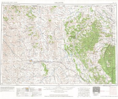
Gillette, Wyoming, Montana, South Dakota, USGS Western US Sectionalized Township Maps
Date
1952
Description
Gillette, WY, MT, SD, USGS Western US Sectionalized Township Maps
Category - Type
Map-Topo
Title
South Pass City, Quadrangle Maps; Series 7.5 Minute
Date
1953
Description
South Pass City [2], USGS WY Quadrangle Maps; Series 7.5 Minute
Category - Type
Map-Topo
Title
Torrington, USGS topographical map; includes Township 24 - Township 35 , Range 58-Range 76
Date
1954
Description
Torrington, USGS topographical map; includes Township 24 - Township 35, Range 58-Range 76
Category - Type
Map-Topo
Title
Ogden, Utah, Wyoming, USGS Western US Sectionalized Township Maps
Date
1954-1966
Description
Ogden, UT, WY, USGS Western US Sectionalized Township Maps, 1954 Limited Revision:1966
Category - Type
Map-Topo
Title
Ogden, Utah, Wyoming, USGS Western US Sectionalized Township Maps
Date
1954-1966
Description
Ogden, UT, WY, USGS Western US Sectionalized Township Maps, 1954 Limited Revision:1966
Category - Type
Map-Topo
Title
Casper Area Topographic Map Township 24-Township 25, Range 77-Range 94
Date
1955
Description
Casper Area Topographic Map by US Geological Survey, includes Township 24-Township 35, Range 77-Range 94
Category - Type
Map-Topo
Title
Preston, Idaho, Wyoming USGS Western US Sectionalized Township Maps
Date
1955-1961
Description
Preston, ID, WY, USGS Western US Sectionalized Township Maps, Limited Revision:1961
Category - Type
Map-Topo
Title
Sheridan, Wyoming, Montana, USGS Western US Sectionalized Township Maps
Date
1955-1962
Description
Sheridan, WY, MT [2], USGS Western US Sectionalized Township Maps, Limited Revision:1962
Category - Type
Map-Topo
Title
Superior, Quadrangle Maps; Series 7.5 Minute
Date
1958
Description
Superior, USGS WY Quadrangle Maps; Series 7.5 Minute
Category - Type
Map-Topo
Title
Cumberland Gap, Quadrangle Maps; Series 7.5 Minute
Date
1962
Description
Cumberland Gap, USGS WY Quadrangle Maps; Series 7.5 Minute
Category - Type
Map-Topo
Title
Kemmerer, Quadrangle Maps; Series 7.5 Minute
Date
1964
Description
Kemmerer, USGS WY Quadrangle Maps; Series 7.5 Minute
Category - Type
Map-Topo
Title
Garland, Quadrangle Maps; Series 7.5 Minute
Date
1966
Description
Garland, USGS WY Quadrangle Maps; Series 7.5 Minute
Category - Type
Map-Topo
Title
Como East, Quadrangle Maps; Series 7.5 Minute
Date
1971
Description
Como East, USGS WY Quadrangle Maps; Series 7.5 Minute
Category - Type
Map-Topo
Title
Como West, Quadrangle Maps; Series 7.5 Minute
Date
1971
Description
Como West, USGS WY Quadrangle Maps; Series 7.5 Minute
Category - Type
Map-Topo
Title
Lander, Quadrangle Maps; Series 7.5 Minute
Date
1978
Description
Lander, USGS WY Quadrangle Maps 1961; Series 7.5 Minute, Photo Revised: 1978
Category - Type
Map-Topo
Title
South Pass City, Quadrangle Maps; Series 7.5 Minute
Date
1978
Description
South Pass City, USGS WY Quadrangle Maps; Series 7.5 Minute, 1953, Photo Revised: 1978
Category - Type
Map-Topo
Title
Wyoming State Boys School/Industrial Institute Topographic Map
Date
1916
Description
WY State Boys School/Industrial Institute Topographic Map by WY State Engineer, 1 set with 1 sheet blueline paper
Category - Type
Map-Topo
Title
Wyoming State Training School Grading Plan for Entrance Drive & Main Lawn,
Date
1932
Description
WY State Training School Grading Plan for Entrance Drive & Main Lawn, includes Emerson Building, Administration Building, Infirmary, includes profiles, retaining wall, elevations, topographic info (?) and highway, 1 set with 1 sheet blueprint
Category - Type
Map-Topo
|