|
REFINE
Browse All : Still Image from 1903
1-50 of 50
Title
Cheyenne Club Six per cent First Mortgage Bond
Date
1903
Description
Cheyenne Club Six per cent First Mortgage Bond, black on white with border, Bond Number 197. Bond shows $50.00 amount, describes mortgage indenture agreement, signed by the President & Secretary of the Cheyenne Club.
Category - Type
Certificate-Certificate
Title
Cheyenne Club Six per cent First Mortgage Bond
Date
1903
Description
Cheyenne Club Six per cent First Mortgage Bond, black on white with border, Bond Number 105. Bond shows $50.00 amount, describes mortgage indenture agreement, signed by the President & Secretary of the Cheyenne Club.
Category - Type
Certificate-Certificate
Title
Fort DA Russell Map
Date
1903
Description
Fort DA Russell Map compiled from existing maps with additions, platted & drawn by Capt Guy HB Smith, 4th Inf, includes building locations & types, fences, telegraph & telephone line, reservoir, railroad, 2 sets (1 set with 1 sheet vellum, 1 set with 1 sheet blueline paper)
Category - Type
Military-Fort DA Russell
Title
Fort Mackenzie site map
Date
1903
Description
Fort Mackenzie site map, 1 complete map & 1 partial map-with 2 sheets
Category - Type
Military-Fort MacKenzie
Title
Fort Mackenzie site map
Date
1903
Description
Fort Mackenzie site map, 1 complete map & 1 partial map-with 2 sheets
Category - Type
Military-Fort MacKenzie
Title
Fort Mackenzie site map
Date
1903
Description
Fort Mackenzie site map, 1 complete map & 1 partial map-with 2 sheets
Category - Type
Military-Fort MacKenzie
Title
Mounted Reconnaissance from Fort DA Russell through Crow Creek Timber Reservation
Date
1903
Description
Mounted Reconnaissance from Fort DA Russell through Crow Creek Timber Reservation, WY; by 1st Lieut. HB Farrar, Artillery Corps Engineer Officer; includes railroad tracks & station designations, boundary of reservation, towns, ranches, roads, mountains, creeks, 1 set with 1 sheet encapsulated blueprint
Category - Type
Military-Fort DA Russell
Title
Pathfinder Reservoir Site, Contour Maps
Date
1903
Description
Pathfinder Reservoir Site, Contour Maps, WY State Engineer Topical Cartographic Records, may include streams, canals, ditches, irrigation & power projects, water rights & plans, 1 set with 9 sheets paper
Category - Type
Map-Water
Title
Pathfinder Reservoir Site, Contour Maps
Date
1903
Description
Pathfinder Reservoir Site, Contour Maps, WY State Engineer Topical Cartographic Records, may include streams, canals, ditches, irrigation & power projects, water rights & plans, 1 set with 9 sheets paper
Category - Type
Map-Water
Title
Pathfinder Reservoir Site, Contour Maps
Date
1903
Description
Pathfinder Reservoir Site, Contour Maps, WY State Engineer Topical Cartographic Records, may include streams, canals, ditches, irrigation & power projects, water rights & plans, 1 set with 9 sheets paper
Category - Type
Map-Water
Title
Pathfinder Reservoir Site, Contour Maps
Date
1903
Description
Pathfinder Reservoir Site, Contour Maps, WY State Engineer Topical Cartographic Records, may include streams, canals, ditches, irrigation & power projects, water rights & plans, 1 set with 9 sheets paper
Category - Type
Map-Water
Title
Pathfinder Reservoir Site, Contour Maps
Date
1903
Description
Pathfinder Reservoir Site, Contour Maps, WY State Engineer Topical Cartographic Records, may include streams, canals, ditches, irrigation & power projects, water rights & plans, 1 set with 9 sheets paper
Category - Type
Map-Water
Title
Pathfinder Reservoir Site, Contour Maps
Date
1903
Description
Pathfinder Reservoir Site, Contour Maps, WY State Engineer Topical Cartographic Records, may include streams, canals, ditches, irrigation & power projects, water rights & plans, 1 set with 9 sheets paper
Category - Type
Map-Water
Title
Pathfinder Reservoir Site, Contour Maps
Date
1903
Description
Pathfinder Reservoir Site, Contour Maps, WY State Engineer Topical Cartographic Records, may include streams, canals, ditches, irrigation & power projects, water rights & plans, 1 set with 9 sheets paper
Category - Type
Map-Water
Title
Pathfinder Reservoir Site, Contour Maps
Date
1903
Description
Pathfinder Reservoir Site, Contour Maps, WY State Engineer Topical Cartographic Records, may include streams, canals, ditches, irrigation & power projects, water rights & plans, 1 set with 9 sheets paper
Category - Type
Map-Water
Title
Pathfinder Reservoir Site, Contour Maps
Date
1903
Description
Pathfinder Reservoir Site, Contour Maps, WY State Engineer Topical Cartographic Records, may include streams, canals, ditches, irrigation & power projects, water rights & plans, 1 set with 9 sheets paper
Category - Type
Map-Water
Title
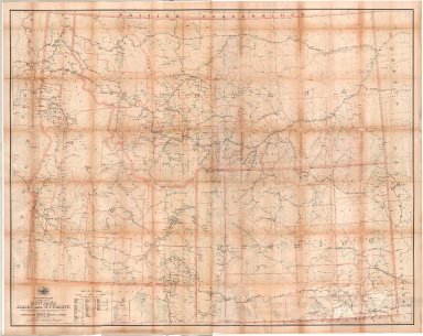
Post Route Map of the States of Montana, Idaho & Wyoming
Date
1903
Description
Post Route Map of the States of Montana, Idaho & WY, by Postmaster General Henry C. Payne, under direction of A. VonHaake, includes East Oregon & Washington, Northeast Utah, West North Dakota, South Dakota & Nebraska, extreme North Colorado, index to counties, designations for: railroads, frequency of mail service, post offices, cities, towns, counties, 1 set colored paper with 2 pages
Category - Type
Map-State
Title
Sections Surrounding Cheyenne and Warren Air Force Base Map
Date
1903
Description
Sections Surrounding Cheyenne and WAFB, 2 Copies
Category - Type
Map-City/Cheyenne
Title
Sections Surrounding Cheyenne and Warren Air Force Base Map
Date
1903
Description
Sections Surrounding Cheyenne and WAFB, 2 Copies
Category - Type
Map-City/Cheyenne
Title
Hartville Geological Atlas Folio
Date
1903
Description
Geological Atlas. Hartville Folio
Category - Type
Map-City/Cheyenne
Title
Hartville Geological Atlas Folio
Date
1903
Description
Geological Atlas. Hartville Folio
Category - Type
Map-City/Cheyenne
Title
Hartville Geological Atlas Folio
Date
1903
Description
Geological Atlas. Hartville Folio
Category - Type
Map-City/Cheyenne
Title
Hartville Geological Atlas Folio
Date
1903
Description
Geological Atlas. Hartville Folio
Category - Type
Map-City/Cheyenne
Title
Hartville Geological Atlas Folio
Date
1903
Description
Geological Atlas. Hartville Folio
Category - Type
Map-City/Cheyenne
Title
Hartville Geological Atlas Folio
Date
1903
Description
Geological Atlas. Hartville Folio
Category - Type
Map-City/Cheyenne
Title
Hartville Geological Atlas Folio
Date
1903
Description
Geological Atlas. Hartville Folio
Category - Type
Map-City/Cheyenne
Title
Hartville Geological Atlas Folio
Date
1903
Description
Geological Atlas. Hartville Folio
Category - Type
Map-City/Cheyenne
Title
Hartville Geological Atlas Folio
Date
1903
Description
Geological Atlas. Hartville Folio
Category - Type
Map-City/Cheyenne
Title
Hartville Geological Atlas Folio
Date
1903
Description
Geological Atlas. Hartville Folio
Category - Type
Map-City/Cheyenne
Title
Hartville Geological Atlas Folio
Date
1903
Description
Geological Atlas. Hartville Folio
Category - Type
Map-City/Cheyenne
Title
Hartville Geological Atlas Folio
Date
1903
Description
Geological Atlas. Hartville Folio
Category - Type
Map-City/Cheyenne
Title
Hartville Geological Atlas Folio
Date
1903
Description
Geological Atlas. Hartville Folio
Category - Type
Map-City/Cheyenne
Title
Hartville Geological Atlas Folio
Date
1903
Description
Geological Atlas. Hartville Folio
Category - Type
Map-City/Cheyenne
Title
Hartville Geological Atlas Folio
Date
1903
Description
Geological Atlas. Hartville Folio
Category - Type
Map-City/Cheyenne
Title
South Dakota, Geological Atlas, Olivet Folio
Date
1903
Description
South Dakota, Geological Atlas, Olivet Folio
Category - Type
Map-Regional
Title
South Dakota, Geological Atlas, Olivet Folio
Date
1903
Description
South Dakota, Geological Atlas, Olivet Folio
Category - Type
Map-Regional
Title
South Dakota, Geological Atlas, Olivet Folio
Date
1903
Description
South Dakota, Geological Atlas, Olivet Folio
Category - Type
Map-Regional
Title
South Dakota, Geological Atlas, Olivet Folio
Date
1903
Description
South Dakota, Geological Atlas, Olivet Folio
Category - Type
Map-Regional
Title
South Dakota, Geological Atlas, Olivet Folio
Date
1903
Description
South Dakota, Geological Atlas, Olivet Folio
Category - Type
Map-Regional
Title
South Dakota, Geological Atlas, Olivet Folio
Date
1903
Description
South Dakota, Geological Atlas, Olivet Folio
Category - Type
Map-Regional
Title
South Dakota, Geological Atlas, Olivet Folio
Date
1903
Description
South Dakota, Geological Atlas, Olivet Folio
Category - Type
Map-Regional
Title
South Dakota, Geological Atlas, Olivet Folio
Date
1903
Description
South Dakota, Geological Atlas, Olivet Folio
Category - Type
Map-Regional
Title
South Dakota, Geological Atlas, Olivet Folio
Date
1903
Description
South Dakota, Geological Atlas, Olivet Folio
Category - Type
Map-Regional
Title
South Dakota, Geological Atlas, Olivet Folio
Date
1903
Description
South Dakota, Geological Atlas, Olivet Folio
Category - Type
Map-Regional
Title
South Dakota, Geological Atlas, Olivet Folio
Date
1903
Description
South Dakota, Geological Atlas, Olivet Folio
Category - Type
Map-Regional
Title
South Dakota, Geological Atlas, Olivet Folio
Date
1903
Description
South Dakota, Geological Atlas, Olivet Folio
Category - Type
Map-Regional
1-50 of 50
|