|
REFINE
Browse All : Still Image from 1908
1-14 of 14
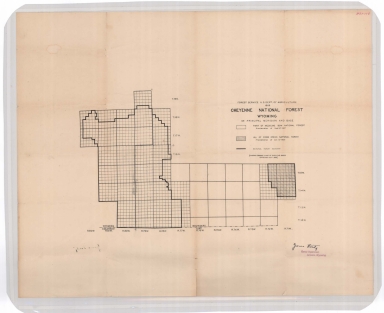
Title
Cheyenne National Forest map
Date
1908
Description
Cheyenne National Forest by US Dept of Agriculture, US Forest Service, includes Crow Creek National Forest boundaries, townships, ranges, sections
Category - Type
Map-Forest/Cheyenne
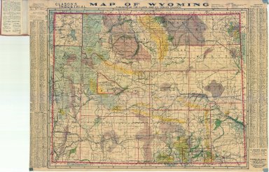
Title
Clason's Industrial Map of Wyoming
Date
1908
Description
Clason's Industrial Map of WY includes townships, ranges, counties, cities, rivers, creeks, coal fields, wagon roads, irrigated lands, city & town index, mineral deposits national forests, 1 copy
Category - Type
Map-State
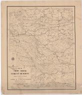
Title
Crow Creek Forest Reserve Map
Date
1908
Description
Crow Creek Forest Reserve Map Albany County, Maneuver Ground by 3rd Battalion of Engineers, PS Bond, EJ Atkinson, includes mountains, cabin, cities, towns, ranches, passes, roads, dams, building locations, contours, linen, colored
Category - Type
Map-Forest/Crow Creek
Title
Crow Creek Forest Reserve Map
Date
1908
Description
Crow Creek Forest Reserve Map Albany County, Maneuver Ground by 3rd Battalion of Engineers, PS Bond, EJ Atkinson, includes mountains, cabin, cities, towns, ranches, passes, roads, dams, building locations, contours, linen, colored
Category - Type
Map-Military
Title
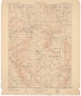
Medicine Bow Quadrangle ( County) Topographic Map
Date
1908
Description
Topographic map Medicine Bow Quadrangle ( County)
Category - Type
Map-Topo
Title
Medicine Bow Quadrangle ( County) Topographic Map
Date
1908
Description
Topographic map Medicine Bow Quadrangle ( County)
Category - Type
Map-Topo
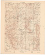
Title
Medicine Bow Quadrangle Map
Date
1908
Description
Medicine Bow Quadrangle Map by US Geological Survey Linen
Category - Type
Map-Topo
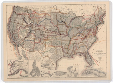
Title
United States Map, showing principle explorers
Date
1908
Description
Map US, showing principle explorers
Category - Type
Map-Trail or Road
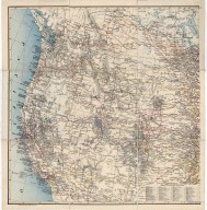
Title
Western United States Map, Guernsey Steel Company Map
Date
1908
Description
Western US Map, Guernsey Steel Company Map includes Pacific with sailing desination distances, state boundaries, mountain relief, lakes & river courses, railroad lines, cities, part of Canada also included for railroad routing purposes, longitude 97-131 degrees, west, latitude 31-53 north. Index of principal railraods is extensive.
Category - Type
Map-Mineral
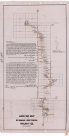
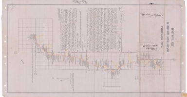
Title
Wyoming Northern Railway Company Location Map
Date
1908
Description
Wyoming Northern Railway Company Location Map from Township 32, Range 67, Section 7 through Township 34, Range 68, Section 36 by Frank S Knittle, 1 set with 1 sheet vellum
Category - Type
Map-Railroad
Title
Wyoming Northern Railway Company Location Map
Date
1908
Description
Wyoming Northern Railway Company Location Map from Township 32, Range 67, Section 7 through Township 34, Range 68, Section 36 by Frank S Knittle, 1 set with 1 sheet vellum
Category - Type
Map-Railroad
Title
Wyoming State Hospital Womens Building Heating Plan
Date
1908
Description
WY State Hospital Womens Building Heating Plan by William Dubois, 1 set with 5 sheets blueprint
Category - Type
Plan/Specification
Title
Wyoming State Hospital Womens Building Plan
Date
1908
Description
WY State Hospital Womens Building Plan, 1 set with 9 sheets blueprint
Category - Type
Plan/Specification
Title
Wyoming State Penitentiary/Arizona Territorial Prison Sallyport Door Operating Devise plan
Date
1908
Description
WY State Penitentiary/Arizona Territorial Prison Sallyport Door Operating Devise by Thorton Fitzhugh, 1 set with 1 sheet blueprint
Category - Type
Plan/Specification
1-14 of 14
|