|
REFINE
Browse All : Still Image of 10
1-14 of 14
Title
Hartville Plat
Date
1888
Description
Hartville Plat by AD Gambill, Mark Martin, includes lots & blocks, streets, railroad, county roads, mill site, gardens, 1 set with 1 sheet vellum, discolored, taped, pieces missing (transcript of plat, 8 sheets paper, filed with plat)
Category - Type
Map-City/Hartville
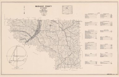
Title
Washakie County Map
Date
1937-1951
Description
Washakie County Map by State Mineral Supervisor Pierre LaFleiche, drafted by HG Lowman includes oil & gas fields, drainage, township, range, state land, primary & secondary roads WPA Project 12/1937, rev 1951, 1 set blueline paper, 2 sets vellum, 1 set mylar
Category - Type
Map-County/Washakie
Title
Washakie County Map
Date
1938
Description
Washakie County Map by Bell & Donnell, Worland, WY includes township, range, school district boundaries, national forests, stock drive way, schools, irrigation district boundaries, Blueline, Colored
Category - Type
Map-County/Washakie
Title
Washakie County Map
Date
1946
Description
Washakie County Map by WY Highway Dept Planning & Research Div, US Dept of Commerce, Bureau of Public Roads includes buildings, air routes, township, range, roads, natural features, drainage, railroads, towns, 2 copies
Category - Type
Map-County/Washakie
Title
Washakie County Map
Date
1958
Description
Washakie County Map by WY Highway Dept Planning & Research Div, US Dept of Commerce, Bureau of Public Roads includes buildings, air routes, township, range, roads, natural features, drainage, railroads, towns, 1 complete set with 2 sheets
Category - Type
Map-County/Washakie
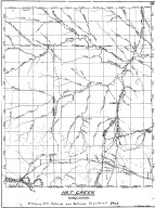
Title
Hat Creek, Cheyenne Deadwood Stage Road Map
Date
1960
Description
10 Hat Creek, Cheyenne Deadwood Stage Road Map by LC Bishop, includes townships, ranges, rivers, creeks, roads, trails, pony express stations, graves, 1 sheet vellum, 15 paper copies
Category - Type
Map-Trail or Road
Title
University of Wyoming, Student Union Laramie, WY plans
Date
1938
Description
University of WY, Student Union (69 sheets), Laramie, WY
Category - Type
Plan/Specification
Title
Wyoming State Training School Girls Dormitory (Mills Cottage)
Date
1949
Description
WY State Training School Girls Dormitory (Mills Cottage), by Frederic Hutchinson Porter, comm 955, building later demolished, 1 incomplete set with 2 sheets blueline paper
Category - Type
Plan/Specification
Title
Wyoming Territorial Prison Park Long Range Plan
Date
1992
Description
WY Territorial Park-Long Range Plan by Jack Rouse Assoc; Meyers & Schmalenberger, May 1992, 1 set with 1 sheet paper
Category - Type
Plan/Specification
Title
Carpenter School Building, Carpenter, WY,
Date
Undated
Description
Carpenter School Building, Carpenter, WY, 3 sheets vellum
Category - Type
Plan/Specification
Title
Rock Springs Municipal Airport Exhibit A
Date
Undated
Description
Rock Springs Municipal Airport Exhibit A, Federal Project 9-48-009-5705, 1 sheet paper
Category - Type
Plan/Specification
Title
University of Wyoming Development Plan, plan of grounds
Date
Undated
Description
University of Wyoming Development Plan, plan of grounds by McCrary & Carhart, 1 set with 1 sheet over-sized blue print (plan 89 A)
Category - Type
Plan/Specification
1-14 of 14
|