|
REFINE
Browse All : Still Image of 2 and Wyoming and Laramie County
1-22 of 22
Title
Fort Laramie to Cheyenne Pass Route
Date
1858
Description
Route from Fort Laramie to Cheyenne Pass by BVT Major Williams with orders to establish a post, includes sketch of Camp Walbach and Pedistal Rock
Category - Type
Military-Camp Walbach
Title
Cheyenne Birds Eye View Map
Date
1882
Description
Cheyenne Birds Eye View Map by Beck & Pauli, JJ Stoner includes streets, avenues, buildings, railroads, 4 building images, index to some buildings 5 copies
Category - Type
Map-Birds Eye View/Cheyenne
Title
Cheyenne Birds Eye View Map
Date
1882
Description
Cheyenne Birds Eye View Map by Beck & Pauli, JJ Stoner includes streets, avenues, buildings, railroads, 4 building images, index to some buildings 5 copies
Category - Type
Map-Birds Eye View/Cheyenne
Title
Cheyenne Experiment Farm Map
Date
1907
Description
Cheyenne Experiment Farm Map, by US Dept of Agriculture, Office of Experiment Stations, includes, types of crops, locations of wells, evaporation tanks, reservoir, roads, railroad, 1 set with 1 sheet blueprint
Category - Type
Map-Site
Title
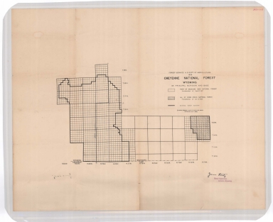
Cheyenne National Forest map
Date
1908
Description
Cheyenne National Forest by US Dept of Agriculture, US Forest Service, includes Crow Creek National Forest boundaries, townships, ranges, sections
Category - Type
Map-Forest/Cheyenne
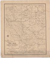
Title
Crow Creek Forest Reserve Map
Date
1908
Description
Crow Creek Forest Reserve Map Albany County, Maneuver Ground by 3rd Battalion of Engineers, PS Bond, EJ Atkinson, includes mountains, cabin, cities, towns, ranches, passes, roads, dams, building locations, contours, linen, colored
Category - Type
Map-Forest/Crow Creek
Title
Laramie County Land Ownership Map
Date
1916
Description
Laramie County Land Ownership Map by EW Glafcke includes township, range, towns, mining district, school district, landowner names, school location, post offices, railroad, highway, roads, rivers, creeks, trails Blueline
Category - Type
Map-County/Laramie
Title
Laramie County Map
Date
1936-1951
Description
Laramie County Map by State Mineral Supervisor Pierre LaFleiche, drafted by HG Lowman includes oil & gas fields, drainage, township, range, state land, primary & secondary roads WPA Project 6999 ca1936, 1945, 1951, 1 set blueline paper, 2 sets vellum, 1 set mylar, 1 set linen
Category - Type
Map-County/Laramie
Title
Laramie County Map
Date
1938
Description
Laramie County Map by WY Highway Dept Planning & Research Div, US Dept of Commerce, Bureau of Public Roads includes buildings, air routes, township, range, roads, natural features, drainage, railroads, towns, 1936 revised in 1938
Category - Type
Map-County/Laramie
Title
Laramie County Map
Date
1946 Circa
Description
Laramie County Map by Murphy Map Company, Missouri includes township, range, roads, highways, interstates, towns, land owners 1 large Xerox Note: Reference only cannot be duplicated
Category - Type
Map-County/Laramie
Title
Laramie County Map
Date
1949
Description
Laramie County Map by WY Highway Dept Research Div, with US Dept of Commence, Bureau of Public Roads includes township, range, roads, drainage, railroads, post offices, schools, Ag exp station, pipe lines, dwellings, towns, 1 complete set with 4 sheets
Category - Type
Map-County/Laramie
Title
Laramie County Map
Date
1949-1951
Description
Laramie County Map by TH Baldwin, includes townships, ranges, sections, cities & towns, rivers & creeks, railroad, highways, 1 set with 1 sheet brown tone vellum
Category - Type
Map-County/Laramie
Title
Laramie County Map
Date
1950
Description
Laramie County Map includes business ads, building indicators, township, range, roads, highways, creeks, towns, railroads, reservoirs, building photos, photograph of airport, key to road types, etc
Category - Type
Map-County/Laramie
Title
Laramie County Map
Date
1950
Description
Laramie County Map includes business ads, building indicators, township, range, roads, highways, creeks, towns, railroads, reservoirs, building photos, photograph of airport, key to road types, etc
Category - Type
Map-County/Laramie
Title
Cheyenne Birds Eye View Map
Date
1974
Description
Cheyenne Birds Eye View Map by Beck & Pauli, JJ Stoner includes streets, avenues, buildings, railroads, 4 building images, index to some buildings 4 copies of a 1974 reprint of 1882 map by Historic Urban Plans from a Library of Congress lithograph #1,
Category - Type
Map-Birds Eye View/Cheyenne
Title
Laramie County Map
Date
1975-1984
Description
Laramie County Map by RH Whitney, Laramie County Engineer, drafted by Shields includes township, range, roads, zoning boundaries, rivers, County subdivisions, reservoirs & railroads 1984, 10/1978, 2/1978, 7/1975 1 original & 1 Xerox
Category - Type
Map-County/Laramie
Title
Wyoming State Childrens Home Floor Plan, Cheyenne plan
Date
Undated
Description
WY State Childrens Home Floor Plan, Cheyenne, 1 set with 4 sheets paper
Category - Type
Plan/Specification
Title
Wyoming Supreme Court Building plan, Cheyenne, WY
Date
Undated
Description
Supreme Court Building, (9 sheets), Cheyenne, WY, (Not with contents pulled from AS FF, probably transferred to State Building Plan Collection)
Category - Type
Plan/Specification
1-22 of 22
|