|
Title
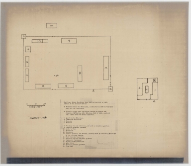
Fort Phil Kearny Outline Map of Surroundings to Illustrate Report of Skirmish with Sioux Indians in Valley of Peno Creek
Date
1866
Description
Fort Phil Kearny Outline Map of Surroundings to Illustrate Report of Skirmish with Sioux Indians in Valley of Peno Creek, 12-6-1866 by Henry Carrington, includes road, route, stream, topo info, hills
Category - Type
Military-Fort Kearny
Title
Fort Phil Kearney Plan for Magazine
Date
1867 Circa
Description
Fort Phil Kearney Plan for Magazine by Henry Carrington
Category - Type
Military-Fort Kearny
Title
Fort Phil Kearney Plans for Log Buildings
Date
1867 Circa
Description
Fort Phil Kearney Plans for Log Buildings by Henry Carrington
Category - Type
Military-Fort Kearny
Title
Fort Phil Kearney Plans for Log Buildings
Date
1867 Circa
Description
Fort Phil Kearney Plans for Log Buildings by Henry Carrington
Category - Type
Military-Fort Kearny
Title
Fort Phil Kearney Plans for Log Buildings
Date
1867 Circa
Description
Fort Phil Kearney Plans for Log Buildings by Henry Carrington
Category - Type
Military-Fort Kearny
Title
Fort Phil Kearny Plans
Date
1868
Description
Fort Phil Kearny Plans 9 sheets Photostat
Category - Type
Military-Fort Kearny
Title
Fort McKinney (No 1), Cantonment Reno Area Map
Date
1876-1878
Description
Fort McKinney (No 1), Cantonment Reno Area Map showing building locations & names, 1 chronar & 2 positive copies
Category - Type
Military-Fort McKinney
Title
Fort McKinney (No 1), Cantonment Reno Area Map
Date
1876-1878
Description
Fort McKinney (No 1), Cantonment Reno Area Map showing building locations & names, 1 chronar & 2 positive copies
Category - Type
Military-Fort McKinney
Title
Fort McKinney (No 1), Cantonment Reno Area Map
Date
1876-1878
Description
Fort McKinney (No 1), Cantonment Reno Area Map showing building locations & names, 1 chronar & 2 positive copies
Category - Type
Military-Fort McKinney
Title
Fort Reno location map
Date
1877 Circa
Description
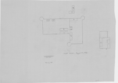
Fort Reno, Map Showing Location of includes fort outline some basic building designations, enlarged map of fort-with building designations and names, topo info, roads, river
Category - Type
Military-Fort Reno
Title
Fort Reno location map
Date
1877 Circa
Description
Fort Reno, Map Showing Location of includes fort outline some basic building designations, enlarged map of fort-with building designations and names, topo info, roads, river
Category - Type
Military-Fort Reno
Title
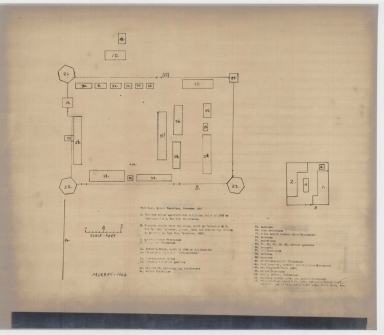
Fort McKinney Plan of the New Post, site map
Date
1879
Description
Fort McKinney Plan of the New Post, site map, 2 copies
Category - Type
Military-Fort McKinney
Title
Fort McKinney Plan of the New Post, site map
Date
1879
Description
Fort McKinney Plan of the New Post, site map, 2 copies
Category - Type
Military-Fort McKinney
Title
Fort McKinney Reservation map
Date
1879
Description
Fort McKinney Reservation map, by Henry J Goldman, 2 copies
Category - Type
Military-Fort McKinney
Title
Fort McKinney Reservation map
Date
1879
Description
Fort McKinney Reservation map, by Henry J Goldman, 2 copies
Category - Type
Military-Fort McKinney
Title
Survey Map Township 45, Range 78, Sections 1 - 36
Date
1882
Description
Survey Map by Edw. C David, surveyed by McCarthy & Moore, Downey & Grant, US Surveyor General's Office, printed-A Gast & Co, Township 45, Range 78, Sections 1 - 36, includes topo info, Brown & Halleck's Ranch, Old Fort Reno Road, telegraph line, roads, Powder River, creeks, total number of acres, dates of contracts, amount of surveys, magnetic declination, No. 1128, 1 set with 1 sheet negative paper
Category - Type
Military-Fort Reno
Title
Fort Reno map
Date
1887
Description
Fort Reno map, 2 copies, 1 photostat, 1 xerox
Category - Type
Military-Fort Reno
Title
Fort Reno map
Date
1887
Description
Fort Reno map, 2 copies, 1 photostat, 1 xerox
Category - Type
Military-Fort Reno
Title
Buffalo Echo, newspaper, 4/22/1887, pages 1 - 4
Date
1887 April 22
Description
Buffalo Echo, newspaper, 4/22/1887, pages 1 - 4
Category - Type
Newspaper
Title
Buffalo Echo, newspaper, 4/22/1887, pages 1 - 4
Date
1887 April 22
Description
Buffalo Echo, newspaper, 4/22/1887, pages 1 - 4
Category - Type
Newspaper
Title
Big Horn Sentinel (Buffalo), newspaper, 5/7/1887, pages 1 - 4
Date
1887 May 07
Description
Big Horn Sentinel (Buffalo), newspaper, 5/7/1887, pages 1 - 4
Category - Type
Newspaper
Title
Big Horn Sentinel (Buffalo), newspaper, 5/7/1887, pages 1 - 4
Date
1887 May 07
Description
Big Horn Sentinel (Buffalo), newspaper, 5/7/1887, pages 1 - 4
Category - Type
Newspaper
Title
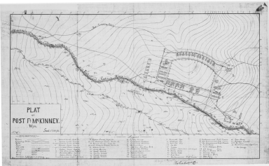
Fort McKinney Plat (Post McKinney)
Date
1895
Description
Fort McKinney Plat (Post McKinney), includes topo info, building locations & designations, 3 copies-positive
Category - Type
Military-Fort McKinney
Title
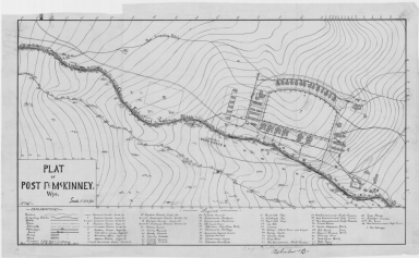
Fort McKinney Plat (Post McKinney)
Date
1895
Description
Fort McKinney Plat (Post McKinney), includes topo info, building locations & designations, 3 copies-positive
Category - Type
Military-Fort McKinney
Title
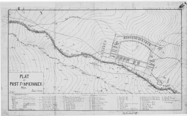
Fort McKinney Plat (Post McKinney)
Date
1895
Description
Fort McKinney Plat (Post McKinney), includes topo info, building locations & designations, 3 copies-positive
Category - Type
Military-Fort McKinney
Title
Chief White Buffalo - Arapahoe, colored poster
Date
1899
Description
Chief White Buffalo - Arapahoe, colored poster by FA Rinehart from Omaha, incl colored image and red border with drawings of bows, arrows, teepes, lake, etc, 1 set with 1 sheet colored paper
Category - Type
Poster
Title
Survey Map Township 44, Range 78, Sections 16 - 18
Date
1899
Description
Survey Map by Alpheus P. Hanson, surveyed by McCarthy & Moore, Downey & Grant, Curtis & Libby, Levi D. West, US Surveyor General's Office, printed-The Norris Peters Co, Township 44, Range 78, Sections 16 - 18, includes McKinney Military Reservation Depot, topo info, river, Douglas to Buffalo Road, house, old channel, total number of acres, dates of contracts, magnetic declination, No. 1831, 1BM, 1 sheet
Category - Type
Military-Fort McKinney
Title
Johnson County Map
Date
1936-1951
Description
Johnson County Map by State Mineral Supervisor Pierre LaFleiche, drafted by H.G. Lowman includes oil & gas fields, drainage, township, range, state land, primary & secondary roads WPA Project 109, 9/1936, rev 1951, 1 set blueline paper, 2 sets vellum
Category - Type
Map-County/Johnson
Title
Johnson County Map
Date
1946
Description
Johnson County Map by WY Highway Dept Planning & Research Div, US Dept of Commerce, Bureau of Public Roads includes buildings, air routes, township, range, roads, natural features, drainage, railroads, towns
Category - Type
Map-County/Johnson
Title
Survey Map by Township 44, Range 78
Date
1946
Description
Survey Map by Thos C Howell, Acting Asst Comm, C Horton Jr, Supervisor of Surveys, US Department of Interior, surveyed by John Tufts, Arthur Brown, John Knowles, Russell MacDonald, Township 44, Range 78, Dependent Resurvey includes dotted line No. 6397, 1 set with 1 sheet negative paper
Category - Type
Military-Fort Reno
Title
Survey Map Township 45, Range 78
Date
1946
Description
Survey Map by Thos C Howell, Acting Asst Comm, C Horton Jr, Supervisor of Surveys, US Department of Interior, surveyed by John Tufts, Arthur Brown, John Knowles, Russell MacDonald, Township 45, Range 78, Dependent Resurvey includes dotted line, Section 14, Powder River, No. 6398, 1 set with 1 sheet negative paper
Category - Type
Military-Fort Reno
Title
Lease map, Township 47, Range 80, Johnson County, WY
Date
1950
Description
Lease map, Township 47 North, Range 80 West, Johnson County, WY. with Legend showing land ownership; lease by number, name, address, & lease date. Map includes lease areas by color & by name &/or lease number
Category - Type
Map-Site
Title
Lease map, Township 47, Range 81, Johnson County, WY
Date
1950
Description
Lease map, Township 47 North, Range 81 West, Johnson County, WY. with legend showing land ownership; lease by number, name, address, & lease date. Map includes lease areas by color & by name &/or lease number
Category - Type
Map-Site
Title
Lease map, Township 48 , Range 81, Johnson County, WY
Date
1950
Description
Lease map, Township 48 North, Range 81 West, Johnson County, WY. with Legend showing land ownership; lease by number, name, address, & lease date. Map includes lease areas by color & by name &/or lease number
Category - Type
Map-Site
Title
Lease map, Township 48, Range 82, Johnson County, WY
Date
1950
Description
Lease map, Township 48 North, Range 82 West, Johnson County, WY. with Legend showing land ownership; lease by number, name, address, & lease date. Map includes lease areas by color & by name &/or lease number
Category - Type
Map-Site
Title
Lease map, Township 49, Range 80, Johnson County, WY
Date
1950
Description
Lease map, Township 49 North, Range 80 West, Johnson County, WY. with Legend showing land ownership; lease by number, name, address, & lease date. Map includes lease areas by color & by name &/or lease number
Category - Type
Map-Site
Title
Lease map, Township 49, Range 81, Johnson County, WY
Date
1950
Description
Lease map, Township 49 North, Range 81 West, Johnson County, WY. with Legend showing land ownership; lease by number, name, address, & lease date. Map includes lease areas by color & by name &/or lease number
Category - Type
Map-Site
Title
Fort Phil Kearney - Map Showing Road to the Pinery
Date
1951
Description
Fort Phil Kearney - Map Showing Road to the Pinery, Johnson County, WY includes Township 53, Range 83, sections, road, creeks, fort location, site of Wagon Box Fight
Category - Type
Military-Fort Kearny
Title
Fort Phil Kearny and Related Sites General Development Plan
Date
1967
Description
Fort Phil Kearny & related sites, General Development Plan 2 copies
Category - Type
Military-Fort Kearny
Title
Fort Reno Plans
Date
1967
Description
Fort Reno Plan 4 sheets, 3 copies NOTE: Access to building plans is restricted.
Category - Type
Military-Fort Reno
Title
Fort Reno Plans
Date
1967
Description
Fort Reno Plan 4 sheets, 3 copies NOTE: Access to building plans is restricted.
Category - Type
Military-Fort Reno
Title
Fort Reno Plans
Date
1967
Description
Fort Reno Plan 4 sheets, 3 copies NOTE: Access to building plans is restricted.
Category - Type
Military-Fort Reno
Title
Fort Reno Plans
Date
1967
Description
Fort Reno Plan 4 sheets, 3 copies NOTE: Access to building plans is restricted.
Category - Type
Military-Fort Reno
Title
Fort Reno Plans
Date
1967
Description
Fort Reno Plan 4 sheets, 3 copies NOTE: Access to building plans is restricted.
Category - Type
Military-Fort Reno
Title
Johnson County Map
Date
1969
Description
Johnson County Map by WY Highway Dept, Planning & Research Div, with US Dept of Commence, Bureau of Public Roads includes township, range, roads, drainage, railroads, post offices, schools, Ag exp stations, pipe lines, dwellings, towns, 1950 County population, 1954 aerial photo 4 sheets 11X17, includes the years: 1956 1961 1967-9
Category - Type
Map-County/Johnson
Title
Fort McKinney/WY Soldiers & Sailors Home Building Plans restoration
Date
1979
Description
Fort McKinney/WY Soldiers & Sailors Home Building Plans restoration, 1 set with 10 double-sided browntone sheets. NOTE: access to building plans restricted
Category - Type
Military-Fort McKinney
|