|
Title
Hartville Plat
Date
1888
Description
Hartville Plat by AD Gambill, Mark Martin, includes lots & blocks, streets, railroad, county roads, mill site, gardens, 1 set with 1 sheet vellum, discolored, taped, pieces missing (transcript of plat, 8 sheets paper, filed with plat)
Category - Type
Map-City/Hartville
Title
Platte County District Court civil case 7-184, exhibit B, DR 12, Map of WY Development Co Reservoir II
Date
1895
Description
Platte County District Court civil case 7-184, exhibit B, DR 12, Map of WY Development Co Reservoir II, by Clarence Johnston includes Township 21 - Township 22, Range 73 - Range 74, river, slough, ridge, road, dam, lakes, divide, topo info, I set with 1 sheet blueline paper
Category - Type
Court Exhibits
Title
Platte County District Court civil case 7-184, exhibit B, DR 13, Map of WY Development Co Reservoir II
Date
1901
Description
Platte County District Court civil case 7-184, exhibit B, DR 13, Map of WY Development Co Reservoir II, by Frank Bond includes Township 21 - Township 22, Range 73 - Range 74, river, slough, ridge, road, dam, lakes, divide, topo info, acreage, 53-4-27, I set with 1 sheet blueline paper
Category - Type
Court Exhibits
Title
Hartville Plat
Date
1904
Description
Hartville Plat, includes streets, mine locations & ownership, 1 set with 1 sheet blueprint
Category - Type
Map-City/Hartville
Title
Platte County District Court civil case 1-54 exhibit 1, DR 2, Survey Map with landowners names for Township 30, Range 69
Date
1906
Description
Platte County District Court civil case 1-54 exhibit 1, DR 2, Survey Map with landowners names for Township 30, Range 69, 1 set with 1 sheet color-coded paper
Category - Type
Court Exhibits
Title
Hartville Plat
Date
1907-1909
Description
Hartville Plat of amended survey of platted portion, Bartlett Addition, patented mining claims by Bartlett Brothers includes lots, blocks, streets, railroads, city reserve, river, hand drawn survey on back
Category - Type
Map-City/Hartville
Title
Hartville Plat
Date
1913
Description
Hartville Plat showing amended survey of platted portion of Bartlett Addition, patented mining claims includes lots, blocks, streets, river, railroad, Blueline
Category - Type
Map-City/Hartville
Title
Platte County District Court civil case file 16-281, DR 34, Lowica No. 2 Ditch Map
Date
1913
Description
Platte County District Court civil case file 16-281, DR 34, Lowica No. 2 Ditch Map by Louis C. Todd, includes Township 25 - Township 26, Range 68 - Range 69, Section, Fish Creek, ditch, flume, floodgate, draw, Lowica Reservoir Enlarged, 1 set with 1 sheet blueline paper
Category - Type
Court Exhibits
Title
Hartville Plat
Date
1913 Circa
Description
Hartville Plat includes lots, blocks, streets, city reserve, Blueline
Category - Type
Map-City/Hartville
Title
Platte County District Court civil case 1-79 exhibit A, DR 3, Township 27, Range 33, Section 32 NE 1/2 Map
Date
1916
Description
Platte County District Court civil case 1-79 exhibit A, DR 3, Township 27, Range 33, Section 32 NE 1/2 Map by Schaub & Bonner, chainmen-P Proell & AL Heitel, includes topo info, 1 set with 1 sheet blueline paper
Category - Type
Court Exhibits
Title
Platte County District Court civil case 3-270, DR5, Logan Drainage District Contour Map
Date
1923
Description
Platte County District Court civil case 3-270, DR5, Logan Drainage District Contour Map, includes Township, Range Section, landowner names, building locations, canal. 1 set with 1 sheet blueprint
Category - Type
Court Exhibits
Title
Platte County District Court civil case 3-270, DR6, Logan Drainage District Profile Map
Date
1923
Description
Platte County District Court civil case 3-270, DR6, Logan Drainage District Profile Map. 1 set with 1 sheet blueprint
Category - Type
Court Exhibits
Title
Platte County District Court civil case 3-33, DR 4, Glendo Canal Map,
Date
1924
Description
Platte County District Court civil case 3-33, DR 4, Glendo Canal Map, Glendo Irrigation District by Albert B. Bartlett, includes township, range, sections, headgate data, canal sections, flumes, tunnels, topo info, roads, ditches, railroads, notations with locations of houses, 1 set with 1 sheet blueprint
Category - Type
Court Exhibits
Title
Hartville Plat
Date
1936
Description
Hartville Plat includes lots, blocks, streets, city reserve (1 vellum copy)
Category - Type
Map-City/Hartville
Title
Platte County Map
Date
1936-1951
Description
Platte County Map by State Mineral Supervisor Pierre LaFleiche, Drafted by HG Lowman includes oil & gas fields, drainage, township, range, state land, primary & secondary roads WPA Project 109, 5/1936, rev 1945, rev 1951, 1 set blueline paper, 2 sets vellum
Category - Type
Map-County/Platte
Title
Platte County Geologic Map
Date
1937
Description
Platte County Geologic Map by Geological Survey of WY, from WY State Planning Board/WY State Planning & Water Conservation Board records, includes townships & ranges, cities & towns, rivers & creeks, highway, railroad, formations, 1 set with 1 sheet blueline paper
Category - Type
Map-County/Platte
Title
Platte County Map
Date
1940
Description
Platte County Map by Albert B Bartlett, Platte County Surveyor includes township, range, towns, rivers, creeks, school districts, electrical & gas lines, roads, highways
Category - Type
Map-County/Platte
Title
Platte County Map
Date
1940
Description
Platte County Map by WY Highway Dept, Planning & Research Div, with US Dept of Commence, Bureau of Public Roads includes township, range, roads, drainage, railroads, post offices, schools, Ag exp station, pipe lines, dwellings, towns,
Category - Type
Map-County/Platte
Title
Platte County District Court civil case 7-184, DR 14, Enlargement Application Map of WY Development Company, No. 1 & No 2 Canals & Tunnels
Date
1941
Description
Platte County District Court civil case 7-184, DR 14, Enlargement Application Map of WY Development Company, No. 1 & No 2 Canals & Tunnels, sheet 1, includes Township 22 - 25, Range 67 - 70, canals, rivers, creeks, reservoirs, lake, tunnel, acreage, 1 set with 1 sheet blueline paper
Category - Type
Court Exhibits
Title
Platte County District Court civil case 7-184, DR 15, Enlargement Application Map of WY Development Company, No. 1 & No 2 Canals & Tunnels
Date
1941
Description
Platte County District Court civil case 7-184, DR 15, Enlargement Application Map of WY Development Company, No. 1 & No 2 Canals & Tunnels, sheet 2, includes Township 22 - 24, Range 69 - 71, canals, rivers, creeks, ditches, lateral, 1 set with 1 sheet blueline paper
Category - Type
Court Exhibits
Title
Platte County District Court civil case 6-145, DR 7, Plaintiff Exhibit 2, Plat Township 25, Range 67 & Range 6
Date
1942
Description
Platte County District Court civil case 6-145, DR 7, Plaintiff Exhibit 2, Plat Township 25, Range 67 & Range 68, includes color-coded sections-red is deeded land and blue is leased land, 1 set with 1 sheet color coded paper (2 pages taped together)
Category - Type
Court Exhibits
Title
Platte County District Court civil case 6-145, DR 8, Plaintiff Exhibit 2, Plat Township 26, Range 69
Date
1942
Description
Platte County District Court civil case 6-145, DR 8, Plaintiff Exhibit 2, Plat Township 26, Range 69, includes color-coded sections-red is deeded land and blue is leased land, 1 set with 1 sheet color-coded paper
Category - Type
Court Exhibits
Title
Platte County District Court civil case 7-184, DR 10, Map of the Wheatland Irrigation District
Date
1946
Description
Platte County District Court civil case 7-184, DR 10, Map of the Wheatland Irrigation District, includes townships, ranges, sections, land ownership, railroads, roads, highways, reservoirs, lakes, ditches, district boundaries, electric lines, Governor Districts, 1 set with 1 sheet color-coded blueline paper
Category - Type
Court Exhibits
Title
Platte County School District Boundary Board Map, a 1940 Highway Map annotated
Date
1949-1955
Description
Platte County School District Boundary Board Map, a 1940 Highway Map annotated to include the school district numbers and boundaries
Category - Type
Map-County/Platte
Title
Platte County District Court civil case 8-254, DR 16, exhibit A, Burned Over Acreage on LD Ranch, Bordeaux, WY
Date
1952
Description
Platte County District Court civil case 8-254, DR 16, exhibit A, Burned Over Acreage on LD Ranch, Bordeaux, WY, by JA Cole, includes Township 22 & Township 23, Range 66 & Range 67, key map with railroad tracks, detail maps of Tract 1, 2, & 3 showing railroad track location & meadow/pasture acreage, 1 set with 1 sheet blueline paper
Category - Type
Court Exhibits
Title
Platte County District Court civil case 8-318, DR 17, exhibit A, Platte County Map
Date
1952
Description
Platte County District Court civil case 8-318, DR 17, exhibit A, Platte County Map by JA Cole, incl township, ranges, sections, highways, roads, trails, land owner names, railroads, river, creeks, hills, laterals, tunnels, reservoirs, towns, power lines, school district boundaries, 1 set with 1 sheet color-coded paper
Category - Type
Court Exhibits
Title
Platte County Map
Date
1952
Description
Platte County Map by WY Highway Dept, Planning & Research Div, with US Dept of Commence, Bureau of Public Roads includes township, range, roads, drainage, railroads, post offices, schools, Ag exp station, pipe lines, dwellings, towns, 1950 Co Population, 1949 aerial photo 2 sets 1 incomplete
Category - Type
Map-County/Platte
Title
Platte County School District Boundary Map, a 1940 Wyoming Highway Department map annotated
Date
1955-1956
Description
Platte County School District Boundary Map, a 1940 Wyoming Highway Department map annotated to include the school district boundary locations and numbers.
Category - Type
Map-County/Platte
Title
Platte County District Court civil case 13-245, DR 29, plaintiff exhibit 1, Lake Shore Tracts
Date
1962
Description
Platte County District Court civil case 13-245, DR 29, plaintiff exhibit 1, Lake Shore Tracts owned by Glendo Dam Development Co, by JA Cole, includes tracts, insert map with brass caps, street names, 1 set with 1 sheet blueline paper
Category - Type
Court Exhibits
Title
Platte County District Court civil case 14-152, DR 30, Map to Accompany Application for Construction of Woody Ditch & Petition to Change Point of Diversion
Date
1963
Description
Platte County District Court civil case 14-152, DR 30, Map to Accompany Application for Cosntruction of Woody Ditch & Petition to Change Point of Diversion?ǪMcConnel Ditch vy JA Cole, includes Township 24 - Township 25, Range 69, Sections, creek, ditch, Detail Map with dyke, old channel, new channel, ditches,cross ection Woody Ditch
Category - Type
Court Exhibits
Title
Platte County Map
Date
1967
Description
Platte County Map by WY Highway Dept, Planning & Research Div, with US Dept of Commence, Bureau of Public Roads includes township, range, roads, drainage, railroads, post offices, schools, Ag exp station, pipe lines, dwellings, towns, 1950 Co population, 1956 aerial photo 16-2
Category - Type
Map-County/Platte
Title
Platte County District Court civil case 11-493, DR19, Bell Fourche Pipeline Co-A Portion of Donkey Creek-Fort Laramie 12" Pipeline Township 28, Range 65, Sections 29 - 6
Date
1968
Description
Platte County District Court civil case 11-493, DR19, Bell Fourche Pipeline Co-A Portion of Donkey Creek-Fort Laramie 12" Pipeline Township 28, Range 65, Sections 29 - 6, Showing Pipeline Stations on Pertinent Subdivison Crossings by Harvey F. Beasley, includes Webb Canon Roady, pipeline & station locations, 1 set with 1 sheet blueline paper
Category - Type
Court Exhibits
Title
Platte County District Court civil case 12-24, DR 21, Map to Accompany Application for O Bar O Reservoir No. 3
Date
1969
Description
Platte County District Court civil case 12-24, DR 21, Map to Accompany Application for O Bar O Reservoir No. 3, by Dean Prosser, surveyed by J Kenneth Kennedy, includes cross-section of spillway, Reservoir Capacity Table with contour, area, average, capacity, insert location map with township, range, section,canal, ditch, 1 set with 1 sheet paper
Category - Type
Court Exhibits
Title
Platte County District Court civil case 12-24, DR 22, Map to Accompany Application for O Bar O Reservoir No. 3
Date
1969
Description
Platte County District Court civil case 12-24, DR 22, Map to Accompany Application for O Bar O Reservoir No. 3, by Dean Prosser, surveyed by J Kenneth Kennedy, includes cross-section of spillway, Reservoir Capacity Table with contour, area, average, capacity, insert location map with township, range, section,canal, ditch, 1 set with 1 sheet paper
Category - Type
Court Exhibits
Title
Platte County District Court civil case 12-251, DR 25, HF Kettleson, Johnston Fuel Liners,Chugwater Creek Diversion
Date
1972
Description
Platte County District Court civil case 12-251, DR 25, HF Kettleson, Johnston Fuel Liners,Chugwater Creek Diversion, includes location map, Table of Quatities with item/part, unit & quanitity; Location Plan with creek, Wayne Weber Road, Lower Bard Ditch, fuel liners, 1 set with 1 sheet blueline paper
Category - Type
Court Exhibits
Title
Platte County District Court civil case 12-251, DR 26, HF Kettleson, Johnston Fuel Liners,Chugwater Creek Diversion
Date
1972
Description
Platte County District Court civil case 12-251, DR 26, HF Kettleson, Johnston Fuel Liners,Chugwater Creek Diversion, includes drawing of rock placed between plank & existing rock, Drawing of gate & wall, pipes, timber, steel post, ditch drawing, 1 set with 1 sheet blueline paper
Category - Type
Court Exhibits
Title
Platte County District Court civil case file 16-281, DR 32, Map to Accompany Proof of Appropriation & Beneficial Use of Underground Water Mello No. 1 Well
Date
1972
Description
Platte County District Court civil case file 16-281, DR 32, Map to Accompany Proof of Appropriation & Beneficial Use of Underground Water Mello No. 1 Well by J. Kenneth Kennedy, includes Township 25, Range 68, Sections 2-3, 11-12, well, 1 set with 1 sheet paper
Category - Type
Court Exhibits
Title
Platte County District Court civil case file 16-281, DR 31, Map to Accompany Proof of Appropriation & Beneficial Use of Irrigated Well Joe No. 2
Date
1977
Description
Platte County District Court civil case file 16-281, DR 31, Map to Accompany Proof of Appropriation & Beneficial Use of Irrigated Well Joe No. 2 by J. Kenneth Kennedy, includes Township 25, Range 68, Sections 2-3, 11-12, wells, 1 set with 1 sheet paper
Category - Type
Court Exhibits
Title
Platte County District Court civil case file 16-281, DR 33, Map to Accompany Proof of Appropriation & Beneficial Use of Underground Water Clara Lou Johnson No. 1 Well
Date
1978
Description
Platte County District Court civil case file 16-281, DR 33, Map to Accompany Proof of Appropriation & Beneficial Use of Underground Water Clara Lou Johnson No. 1 Well, by J. Kenneth Kennedy, includes Township 25, Range 68, Sections 2, 11, Lowica Reservoir , Lowica Ditch, North Laramie River, well, list of related surface rights, 1 set with 1 sheet paper
Category - Type
Court Exhibits
Title
Platte County Map
Date
1993
Description
Map of Platte County, WY, includes Wheatland, Chugwater, Glendo, Guernsey city maps w/streets, railroad, highways, business directory, business ads-Side 1. Side 2 includes regional map, highways, water bodies, streams scale, street index, railroads, framed by business adds,
Category - Type
Map-County/Platte
Title
Platte County District Court civil case 1-54 exhibit A, DR 1, Township 26 - Township 28, Range 33 - 34 Map includes creek, ditch, location of Megge's Home & Moran's Ranch
Date
Undated
Description
Platte County District Court civil case 1-54 exhibit A, DR 1, Township 26 - Township 28, Range 33 - 34 Map includes creek, ditch, location of Megge's Home & Moran's Ranch, 1 set with 1 sheet color-coded paper
Category - Type
Court Exhibits
Title
Platte County District Court civil case 11-120, DR 18, exhibit 1, George W. Locke Claim Map Township 24, Range 70 Section 3
Date
Undated
Description
Platte County District Court civil case 11-120, DR 18, exhibit 1, George W. Locke Claim Map by James I. Burns, includes Township 24, Range 70 Section 3, lots and mine names, 1 set with 1 sheet paper
Category - Type
Court Exhibits
Title
Platte County District Court civil case 11-597, DR 20, drawing
Date
Undated
Description
Platte County District Court civil case 11-597, DR 20, drawing showing outline of one building with location of table and three connected exterior buildings, north, south, east, west coordinates, 1 set with 1 sheet paper
Category - Type
Court Exhibits
Title
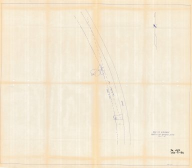
Platte County District Court civil case 12-183, DR 24, Map of Highway North of Wheatland
Date
Undated
Description
Platte County District Court civil case 12-183, DR 24, Map of Highway North of Wheatland, includes building location, line of sight, trees, right of way fence, 1 set with 1 sheet paper
Category - Type
Court Exhibits
Title
Platte County District Court civil case 12-251, DR 27, Wayne Weber Pipeline
Date
Undated
Description
Platte County District Court civil case 12-251, DR 27, Wayne Weber Pipeline, includes location map with township & range, creek, ditch, road & building locations; Quantities Table with items/parts, units & quantities; Profile of pipe, steel box with trash screen, drain, creek bottom, plan & riser, 1 set with 1 sheet blueline paper
Category - Type
Court Exhibits
Title
Platte County District Court civil case 12-348, DR 28, Map of Chugwater Ditch No 1
Date
Undated
Description
Platte County District Court civil case 12-348, DR 28, Map of Chugwater Ditch No 1, icludes Township 23 - Township 24, Range 67, Sections, creek, ditch, land ownership, 1 set with 1 sheet paper
Category - Type
Court Exhibits
Title
Platte County District Court civil case 12-45, DR 23, Map of Portion West Subdivision Guernsey, WY
Date
Undated
Description
Platte County District Court civil case 12-45, DR 23, Map of Portion West Subdivision Guernsey, WY, includes street names and lots, 1 set with 1 sheet paper
Category - Type
Court Exhibits
|