|
REFINE
Browse All : Still Image of Wyoming and Guernsey and CD Box 3/RR1188-CD140
1-1 of 1
Title
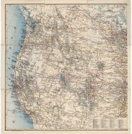
Western United States Map, Guernsey Steel Company Map
Date
1908
Description
Western US Map, Guernsey Steel Company Map includes Pacific with sailing desination distances, state boundaries, mountain relief, lakes & river courses, railroad lines, cities, part of Canada also included for railroad routing purposes, longitude 97-131 degrees, west, latitude 31-53 north. Index of principal railraods is extensive.
Category - Type
Map-Mineral
1-1 of 1
|
