|
REFINE
Browse All : Still Image of Wyoming from 1910
1-17 of 17
Title
Atlas of the World byRand, McNally & Co, includes Wyoming
Date
1910
Description
Rand, McNally & CO's Indexed Atlas of the World, Map of WY copyrighted 1910 & 1895 includes townships, ranges, counties, cities & towns, mountains, lakes, railroads, 1 sheet color page
Category - Type
Map-State
Title
Fort DA Russell Partial Plat,
Date
1910
Description
Fort DA Russell Partial Plat, showing Proposed Sidewalks, Roads & Grading, by the Constructing Quartermaster Office, includes building designations & names, grades, crossing types, proposed building sites, culverts, 1 set with 1 sheet blueprint
Category - Type
Military-Fort DA Russell
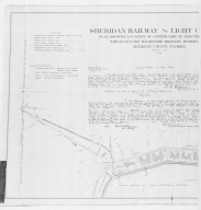
Title
Fort Mackenzie Sheridan Railway & Light Co location plat
Date
1910
Description
Fort Mackenzie Sheridan Railway & Light Co location plat-electrical railway-partial, 3 sheets
Category - Type
Military-Fort MacKenzie
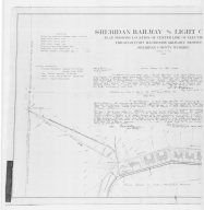
Title
Fort Mackenzie Sheridan Railway & Light Co location plat
Date
1910
Description
Fort Mackenzie Sheridan Railway & Light Co location plat-electrical railway-partial, 3 sheets
Category - Type
Military-Fort MacKenzie
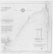
Title
Fort Mackenzie Sheridan Railway & Light Co location plat
Date
1910
Description
Fort Mackenzie Sheridan Railway & Light Co location plat-electrical railway-partial, 3 sheets
Category - Type
Military-Fort MacKenzie
Title
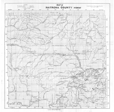
Natrona County Map
Date
1910
Description
Natrona County Map by Fred E Peace, includes townships, ranges, sections, cities & towns, roads & wagon roads, rivers & creeks, mines, railroads & railroad stations, ranches, 1 set with 1 sheet paper
Category - Type
Map-County/Natrona
Title
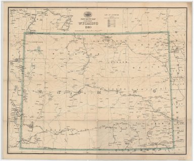
Post Route Map of Wyoming
Date
1910
Description
Post Route Map of WY by the US Postal Service
Category - Type
Map-State
Title
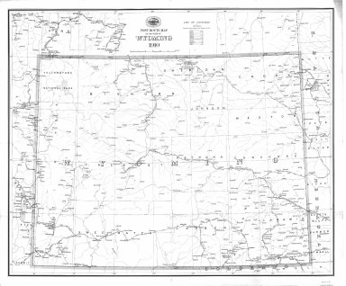
Post Route Map of Wyoming
Date
1910
Description
Post Route Map of WY by the US Postal Service
Category - Type
Map-State
Title
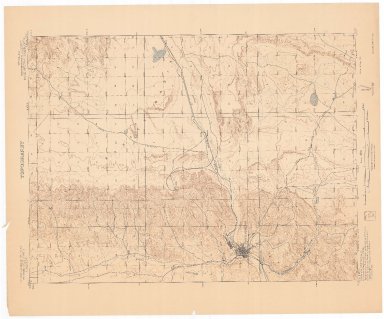
Rock Springs Quadrangle (Sweetwater County) Topographic Map
Date
1910
Description
Topographic map Rock Springs Quadrangle (Sweetwater County)
Category - Type
Map-Topo
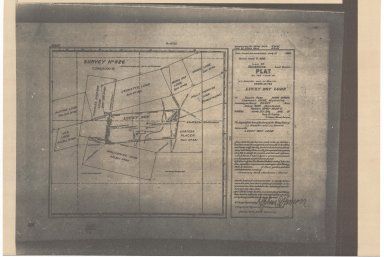
Title
South Pass Mining District Plat of LL Giessler & JJ Morrin Claim, known as the Lucky Boy Lode
Date
1910
Description
South Pass Mining District Plat of LL Giessler & JJ Morrin Claim, known as the Lucky Boy Lode includes location & names of lodes, rivers, city buildings, 1 sheet paper
Category - Type
Map-Site
Title
Wyoming Hot Springs State Park Foot Bridge Plans
Date
1910
Description
Wyoming Hot Springs State Park Foot Bridge Plans, 1 set with 3 sheets blueprint (undersized)
Category - Type
Plan/Specification
Title
Wyoming State Penitentiary/Oklahoma State Prison Locking Device for Doors to Buildings "C" & "D" Plan
Date
1910
Description
WY State Penitentiary/Oklahoma State Prison Locking Device for Doors to Buildings "C" & "D"? Plan, by Paulley Jail Building Co, 1 set with 5 sheets blueprint
Category - Type
Plan/Specification
Title
Wyoming Training School/Institution for the Feeble Minded Building, Lander, WY plans
Date
1910
Description
Wyoming Training School/Institution for the Feeble Minded Building, Lander, WY, 8 sheets vellum
Category - Type
Plan/Specification
Title
County Road Right-of-Way Near Fort Steele
Date
1910
Description
County Road Right-of-Way Near Fort Steele, Proposed by JRE Turpin, 3 sets with 1 sheet blueprint
Category - Type
Map-Trail or Road
Title
Fort Russell, Topo map
Date
1910
Description
Fort Russell, Topo.
Category - Type
Military-Fort DA Russell
Title
Pine Bluffs Block 8 plat
Date
1910
Description
Pine Bluffs Block 8 plat
Category - Type
Map-City/Pine Bluffs
1-17 of 17
|