|
Title
Laramie River & Tributaries Tabulations of Adjudicated Water
Date
1869-1911
Description
Laramie River & Tributaries Tabulations of Adjudicated Water Rights, WY State Engineer, includes priority number, ditch name, name of appropriator, Post Office address, use, amount appropriated, number of acres irrigated & description of lands irrigated, 2 bundles with 36 sheets paper
Category - Type
Map-Water
Title
Pathfinder Reservoir Site, Contour Maps
Date
1903
Description
Pathfinder Reservoir Site, Contour Maps, WY State Engineer Topical Cartographic Records, may include streams, canals, ditches, irrigation & power projects, water rights & plans, 1 set with 9 sheets paper
Category - Type
Map-Water
Title
Pathfinder Reservoir Site, Contour Maps
Date
1903
Description
Pathfinder Reservoir Site, Contour Maps, WY State Engineer Topical Cartographic Records, may include streams, canals, ditches, irrigation & power projects, water rights & plans, 1 set with 9 sheets paper
Category - Type
Map-Water
Title
Pathfinder Reservoir Site, Contour Maps
Date
1903
Description
Pathfinder Reservoir Site, Contour Maps, WY State Engineer Topical Cartographic Records, may include streams, canals, ditches, irrigation & power projects, water rights & plans, 1 set with 9 sheets paper
Category - Type
Map-Water
Title
Pathfinder Reservoir Site, Contour Maps
Date
1903
Description
Pathfinder Reservoir Site, Contour Maps, WY State Engineer Topical Cartographic Records, may include streams, canals, ditches, irrigation & power projects, water rights & plans, 1 set with 9 sheets paper
Category - Type
Map-Water
Title
Pathfinder Reservoir Site, Contour Maps
Date
1903
Description
Pathfinder Reservoir Site, Contour Maps, WY State Engineer Topical Cartographic Records, may include streams, canals, ditches, irrigation & power projects, water rights & plans, 1 set with 9 sheets paper
Category - Type
Map-Water
Title
Pathfinder Reservoir Site, Contour Maps
Date
1903
Description
Pathfinder Reservoir Site, Contour Maps, WY State Engineer Topical Cartographic Records, may include streams, canals, ditches, irrigation & power projects, water rights & plans, 1 set with 9 sheets paper
Category - Type
Map-Water
Title
Pathfinder Reservoir Site, Contour Maps
Date
1903
Description
Pathfinder Reservoir Site, Contour Maps, WY State Engineer Topical Cartographic Records, may include streams, canals, ditches, irrigation & power projects, water rights & plans, 1 set with 9 sheets paper
Category - Type
Map-Water
Title
Pathfinder Reservoir Site, Contour Maps
Date
1903
Description
Pathfinder Reservoir Site, Contour Maps, WY State Engineer Topical Cartographic Records, may include streams, canals, ditches, irrigation & power projects, water rights & plans, 1 set with 9 sheets paper
Category - Type
Map-Water
Title
Pathfinder Reservoir Site, Contour Maps
Date
1903
Description
Pathfinder Reservoir Site, Contour Maps, WY State Engineer Topical Cartographic Records, may include streams, canals, ditches, irrigation & power projects, water rights & plans, 1 set with 9 sheets paper
Category - Type
Map-Water
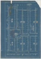
Title
Casper Zoning Map
Date
1904
Description
Casper Map, includes lots & blocks, streets & avenues, North Platte River, railroad tracks, Depot Grounds-Wyoming Central Railway, 1 set with 1 sheet blueprint
Category - Type
Map-City/Casper
Title
North Platte Project, Pathfinder Dam map & plans (amended)
Date
1905
Description
North Platte Project, Pathfinder Dam map & plans (amended) by JH Quinton-Supervising Engineer, CE Wells-Project Engineer, for US Geological Survey, 53-13-8, 1 set with 2 sheets colored paper + back cover
Category - Type
Map-Water
Title
Cheyenne Experiment Farm Map
Date
1907
Description
Cheyenne Experiment Farm Map, by US Dept of Agriculture, Office of Experiment Stations, includes, types of crops, locations of wells, evaporation tanks, reservoir, roads, railroad, 1 set with 1 sheet blueprint
Category - Type
Map-Site
Title
Fort DA Russell Partial Plat,
Date
1910
Description
Fort DA Russell Partial Plat, showing Proposed Sidewalks, Roads & Grading, by the Constructing Quartermaster Office, includes building designations & names, grades, crossing types, proposed building sites, culverts, 1 set with 1 sheet blueprint
Category - Type
Military-Fort DA Russell
Title
Lovell Canal, Lands for Patents
Date
1915
Description
Lovell Canal, Lands for Patents, WY State Engineer Topical Cartographic Records, may include streams, canals, ditches, irrigation & power projects, water rights & plans, 1 set with 1 sheet paper
Category - Type
Map-Water
Title
Lovell Canal
Date
1916
Description
Lovell Canal, WY State Engineer Topical Cartographic Records, may include streams, canals, ditches, irrigation & power projects, water rights & plans, 1 set with 1 sheet paper
Category - Type
Map-Water
Title
Big Bend Drainage District, Map
Date
1923
Description
Big Bend Drainage District, Map 1033, WY State Engineer Topical Cartographic Records, may include streams, canals, ditches, irrigation & power projects, water rights & plans, 1 set with 1 sheet paper (Hand-Drawn)
Category - Type
Map-Water
Title
Frannie Division Settlers-Shoshone Project Wyoming-US Reclamation Service-Department of the Interior
Date
1923 March 16, revised
Description
Y-3578.04, Frannie Division Settlers, Shoshone Project Wyoming, US Reclamation Service, Department of the Interior, showing ownership of farms by name with farm serial numbers, includes river, irrigation ditches, reservoirs, US townsites including Deaver and Frannie, private townsites including Cowley, state school sections, US reserves, CB&Q railroad, 1 set with 1 sheet blue line paper
Category - Type
Map-Water
Title
Horse Creek & Tributaries, Ditches Diverting From
Date
1925
Description
Horse Creek & Tributaries, Ditches Diverting From, WY State Engineer Topical Cartographic Records, may include streams, canals, ditches, irrigation & power projects, water rights & plans, 1 set with 2 sheets paper
Category - Type
Map-Water
Title
Index to Topographic Maps & Geologic Folios
Date
1929
Description
Index to Topographic Maps & Geologic Folios, WY State Engineer by US Geological Survey including streams, forests & lands, 1 set with 1 sheet paper
Category - Type
Map-Geological
Title
Index to Topographic Maps & Geologic Folios
Date
1929
Description
Index to Topographic Maps & Geologic Folios, WY State Engineer by US Geological Survey including streams, forests & lands, 1 set with 1 sheet paper
Category - Type
Map-Geological
Title
Index to Topographic Maps & Geologic Folios
Date
1929
Description
Index to Topographic Maps & Geologic Folios, WY State Engineer by US Geological Survey including streams, forests & lands, 1 set with 1 sheet paper
Category - Type
Map-Topo
Title
Index to Topographic Maps & Geologic Folios
Date
1929
Description
Index to Topographic Maps & Geologic Folios, WY State Engineer by US Geological Survey including streams, forests & lands, 1 set with 1 sheet paper
Category - Type
Map-Topo
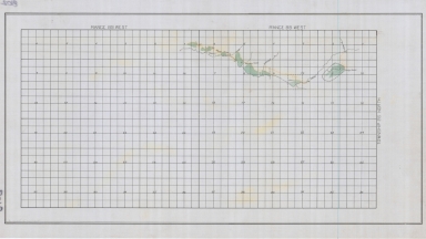
Title
French Creek & Johnson Creek-lands irrigated by map
Date
1930
Description
French Creek & Johnson Creek-lands irrigated by map, by Floyd M Roush, WY State Engineer Office, includes Township 50 - 51, Range 82 - 84, sections, creeks, designations of lands having water rights & lands having a supplemental water supply, 1 set with 1 sheet blueprint
Category - Type
Map-Water
Title
Yellowstone River-Missouri River & Tributaries, Wind River Indian Irrigation Projects
Date
1932
Description
Yellowstone River-Missouri River & Tributaries, Wind River Indian Irrigation Projects, WY State Engineer Topical Cartographic Records, may include streams, canals, ditches, irrigation & power projects, water rights & plans, 1 set with 1 sheet paper
Category - Type
Map-Water
Title
Laramie County-Public Roads Administration-Highway Planning Survey
Date
1940
Description
Laramie County-Public Roads Administration-Highway Planning Survey, WY State Engineer Highway Map, may include forests, trails, railroads, geology, improvements & industry, 1 set with 1 sheet paper
Category - Type
Map-County/Laramie
Title
Fossil & Vicinity, WY-Topographic Map
Date
1943
Description
Fossil & Vicinity, WY-Topographic Map, WY State Engineer by US Geological Survey including streams, forests & lands, 1 set with 1 sheet paper
Category - Type
Map-Topo
Title
Index to Topographic Maps & Geologic Folios
Date
1943
Description
Index to Topographic Maps & Geologic Folios, WY State Engineer by US Geological Survey including streams, forests & lands, 1 set with 1 sheet paper
Category - Type
Map-Geological
Title
Index to Topographic Maps & Geologic Folios
Date
1943
Description
Index to Topographic Maps & Geologic Folios, WY State Engineer by US Geological Survey including streams, forests & lands, 1 set with 1 sheet paper
Category - Type
Map-Geological
Title
Index to Topographic Maps & Geologic Folios
Date
1943
Description
Index to Topographic Maps & Geologic Folios, WY State Engineer by US Geological Survey including streams, forests & lands, 1 set with 1 sheet paper
Category - Type
Map-Topo
Title
Index to Topographic Maps & Geologic Folios
Date
1943
Description
Index to Topographic Maps & Geologic Folios, WY State Engineer by US Geological Survey including streams, forests & lands, 1 set with 1 sheet paper
Category - Type
Map-Topo
Title
Delfelder Drainage District, Map
Date
Undated
Description
Delfelder Drainage District, Map 1029, WY State Engineer Topical Cartographic Records, may include streams, canals, ditches, irrigation & power projects, water rights & plans, 1 set with 2 sheets paper, (Hand-Drawn)
Category - Type
Map-Water
Title
Green River & Tributaries, South Fork of Horse Creek & Horse Creek, Map
Date
Undated
Description
Green River & Tributaries, South Fork of Horse Creek & Horse Creek, Map 8012, WY State Engineer Topical Cartographic Records, may include streams, canals, ditches, irrigation & power projects, water rights & plans, 1 set with 1 sheet paper
Category - Type
Map-Water
Title
Lovell Bench Drainage District, Map
Date
Undated
Description
Lovell Bench Drainage District, Map 1025, WY State Engineer Topical Cartographic Records, may include streams, canals, ditches, irrigation & power projects, water rights & plans, 1 set with 2 sheets paper (Hand-Drawn)
Category - Type
Map-Water
Title
Lovell Drainage District, Map
Date
Undated
Description
Lovell Drainage District, Map 1031, WY State Engineer Topical Cartographic Records, may include streams, canals, ditches, irrigation & power projects, water rights & plans, 1 set with 1 sheet paper (Hand-Drawn)
Category - Type
Map-Water
Title
Post/Fort McKinney Plat
Date
Undated
Description
Post/Fort McKinney Plat, includes building designations, type & list, ditches, roads, fence, sidewalk, sewer & water pipes, topo info, river, 1 set with 1 sheet blueprint
Category - Type
Military-Fort McKinney
Title
Riverton Valley Drainage District, Map
Date
Undated
Description
Riverton Valley Drainage District, Map 1036, WY State Engineer Topical Cartographic Records, may include streams, canals, ditches, irrigation & power projects, water rights & plans, 1 set with 1 sheet paper (Hand-Drawn)
Category - Type
Map-Water
Title
Wyoming State Engineer Streams & Diversions Map of Little Camp Creek, Muddy Creek, Whiskey Creek, Mahoney Ditch, Muddy Creek Ditch, Speyer Ditch, Hays Ditch
Date
Undated
Description
WY State Engineer Streams & Diversions Map of Little Camp Creek, Muddy Creek, Whiskey Creek, Mahoney Ditch, Muddy Creek Ditch, Speyer Ditch, Hays Ditch in Township 27, Range 89-Range 90, Map 8102, 1 set with 1 sheet paper
Category - Type
Map-Water
Title
Wyoming State Engineer Streams & Diversions Map of Muddy Creek, Cottonwood Creek, June Creek, Marsh Ditch in Township 26, Range 88-Range 89
Date
Undated
Description
WY State Engineer Streams & Diversions Map of Muddy Creek, Cottonwood Creek, June Creek, Marsh Ditch in Township 26, Range 88-Range 89, Map 8102, 1 set with 1 sheet paper
Category - Type
Map-Water
Title
Wyoming State Training School/School for Defectives Septic Tank Plan
Date
1922
Description
WY State Training School/School for Defectives Septic Tank Plan by Higby & Gonin, 52-19-8, 1 set with 1 sheet blueprint
Category - Type
Plan/Specification
Title
Wyoming State Training School/School for Defectives Septic Tank Plan
Date
1922-1925
Description
WY State Training School/School for Defectives Septic Tank Plan by Higby & Gonin, 52-19-8, 1 set with 1 sheet blueprint (also has small sheet stapled to plan)
Category - Type
Plan/Specification
Title
Laramie Sanitary Sewers & Sewage Disposal Works Plans & Profiles
Date
1923
Description
Laramie Sanitary Sewers & Sewage Disposal Works Plans & Profiles, by Black & Veatch, 1 set with 20 sheets ( 17 sheets-blueprint, 1 sheet-blueline paper, 2 sheets-back cover paper)
Category - Type
Plan/Specification
Title
Wyoming State Training School-Water Supply Lines, includes Township 33, Range 99, Section 8, 9, 16, 17
Date
1925
Description
WY State Training School-Water Supply Lines, includes Township 33, Range 99, Section 8, 9, 16, 17, river, ditches, laterals, land ownership, permit numbers, 522-19-8, 1 set with 1 sheet vellum
Category - Type
Plan/Specification
Title
Wyoming State Training School Septic Tank plan
Date
1929
Description
WY State Training School Septic Tank plan, by RD Goodrich, 52-19-8, includes a cover letter attached to plan, 1 set with 1 sheet vellum
Category - Type
Plan/Specification
Title
Wyoming State Capitol Building, Wyoming State Engineer Office-Repairs & Alterations to Floor Construction
Date
1931
Description
WY State Engineer Office-Repairs & Alterations to Floor Construction, WY State Capitol Building, by William Dubois, 54-7, 1 set with 1 sheet blueprint
Category - Type
Plan/Specification
|