|
Collection Number
WPA Subject 413 Boomerang 1906
Item Description
Boomerang 1906 newspaper transcriptions "Laramie Boomerang"
Date
1906
Collection Number
WPA Subject 1179 Albany County newspaper transcriptions
Item Description
Albany County newspaper transcriptions from various Laramie papers
Date
1906
Collection Number
WPA Subject 1613 Livestock industry sheep
Item Description
Livestock industry sheep newspaper transcriptions "Laramie Republican"
Date
1906
Title
Burlington Railroad in the Big Horn Basin Route Map
Date
1906
Description
Map Route of Burlington Railroad in the Big Horn Basin
Category - Type
Map-Railroad
Title
Burlington Railroad in the Big Horn Basin Route Map
Date
1906
Description
Map Route of Burlington Railroad in the Big Horn Basin
Category - Type
Map-Railroad
Title
Fort Mackenzie site map-partial
Date
1906
Description
Fort Mackenzie-site map-partial, 3 sheets
Category - Type
Military-Fort MacKenzie
Title
Fort Mackenzie site map-partial
Date
1906
Description
Fort Mackenzie-site map-partial, 3 sheets
Category - Type
Military-Fort MacKenzie
Title
Fort Mackenzie site map-partial
Date
1906
Description
Fort Mackenzie-site map-partial, 3 sheets
Category - Type
Military-Fort MacKenzie
Title
Fort Washakie General Order War Department
Date
1906
Description
Fort Washakie General Order War Department, xerox
Category - Type
Military-Fort Washakie
Title
Fort Washakie Military Reservation plat
Date
1906
Description
Fort Washakie Military Reservation plat
Category - Type
Military-Fort Washakie
Title
Fort Washakie Military Reservation plat
Date
1906
Description
Fort Washakie Military Reservation plat
Category - Type
Military-Fort Washakie
Title
Fort Washakie Military Reservation plat
Date
1906
Description
Fort Washakie Military Reservation plat
Category - Type
Military-Fort Washakie
Title
Platte County District Court civil case 1-54 exhibit 1, DR 2, Survey Map with landowners names for Township 30, Range 69
Date
1906
Description
Platte County District Court civil case 1-54 exhibit 1, DR 2, Survey Map with landowners names for Township 30, Range 69, 1 set with 1 sheet color-coded paper
Category - Type
Court Exhibits
Title
Resurvey Map Township 55, Range 100, Section 1 - 36
Date
1906
Description
Resurvey Map by Alpheus P. Hanson, US Surveyor General, surveyed by Brunt & Bandy, Arthur H Brunt, US Dept of Interior, includes Township 55, Range 100, Sec 1 - 36, lots, topo info, Shoshone River, Garland to Cody Road, Cody to Red Lodge Road, road, telegraph line, B&M Railroad Track, B&M Pump House, School Sections, creeks, Private Land Claims Table with lot no., total acres & acres in township, No. 3422, 2 sets with 1 sheet negative paper
Category - Type
Map-Survey
Title
Resurvey Map Township 55, Range 101, Sections 1 - 36
Date
1906
Description
Resurvey Map by Alpheus P. Hanson, surveyed by Brunt & Bandy, Arthur H. Brunt, US Surveyor General's Office, Township 55, Range 101, Sections 1 - 36, includes lots, acres, creeks, Garland to Cody Road, Cody to Red Lodge Road, roads, B&M Railroad, Shoshone River, bridge, telegraph line, Private Land Claims Table with lot no. & acres; contract dates, amount of surveys, survey dates, 3 sets-1 set with 1 sheet browntone paper, 2 sets with 1 sheet blueprint
Category - Type
Map-Survey
Title
Resurvey Map Township 56, Range 100, Section 1 - 36
Date
1906
Description
Resurvey Map by Alpheus P. Hanson, US Surveyor General, surveyed by Brunt & Bandy, CA Honey, Arthur H Brunt, US Dept of Interior, includes Township 56, Range 100, Sec 1 - 36, lots, topo info, Shoshone River, Cody to Red Lodge Road, roads, creeks, School Sections, Private Land Claims Table with lot no., total acres & acres in township, No. 3433, 1 set with 1 sheet negative paper
Category - Type
Map-Survey
Title
Sheridan Birds Eye View Map
Date
1906
Description
Sheridan Birds Eye View Map includes images of buildings, index, creek
Category - Type
Map-Birds Eye View/Sheridan
Title
Wind River Indian Reservation Plat of Ceded Area to be Opened for Settlement
Date
1906
Description
Wind River Indian Reservation Plat of Ceded Area to be Opened for Settlement, by Edward F. Stahle & Frank M Johnson, includes, Township, Range, Section, Cities & Towns, Roads, Lands Allocated to Indians, Area Open for Settlement, Mineral, Proposed Canals, Ditches, Registration Places, 9 paper copies colored, 1 mylar copy, 1 chronar copy
Category - Type
Map-Site
Title
Wyoming Map
Date
1906
Description
WY Map by Kenyon Printing & Manufacturing Co. copyrighted in 1906 by George F Cram index to towns, counties and railroads on back, Stockgrowers National Bank stamped on front Xerox copy. Map includes townships & ranges, counties, cities & towns, railroads, mountains & hills, rivers and lakes, 1 set with 1 sheet xerox paper
Category - Type
Map-State
Title
Pioneer School Building Plan
Date
1906
Description
Pioneer School Building Plan by Vernon L. Drake, 5507, 1 set with 6 sheets blueline paper
Category - Type
Plan/Specification
Title
Wyoming State Hospital Evanston-Aspen Road Plat
Date
1906
Description
WY State Hospital Evanston-Aspen Road Plat, includes Evanston, hospital grounds, road, railroad, river, 2 copies with 1 sheet vellum
Category - Type
Map-Trail or Road
Title
Wyoming State Hospital Water Plat of Township 15, Range 120
Date
1906
Description
WY State Hospital Water Plat of Township 15, Range 120 by Clarence Johnson-WY State Engineer, includes river, city canal, land to be irrigated, railroad, 1 set with 1 sheet blueprint
Category - Type
Map-Water
Folder or Collection Name
Benson-Bray Collection (P70-143)
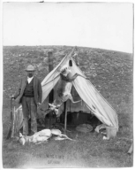
Image Title
"THE WYOMING LIMIT OF 1906", LAWSON BRAY, HUNTER, GUIDE, TAXIDERMIST AT CAMP STANDING IN FRONT OF TENT WITH RIFLE, 2 DEAD ANTELOPE AND A RABBIT
Coverage or Location
Unknown
Date
1906
Folder or Collection Name
Bio File - DURBIN, THOMAS F
Image Title
THOMAS F. DURBIN AT HIS OFFICE IN THE STATE HOUSE OFFICE OF LIVESTOCK COMMISSIONER
Coverage or Location
Cheyenne, Wyoming
Date
1906
Folder or Collection Name
Carrigen Collection (P86-19)
Image Title
MCKINLEY SCHOOL CLASS ROOM 12
Coverage or Location
Casper, Wyoming
Date
1906
Folder or Collection Name
Cities & Towns - Basin
Image Title
MRS. JOHN ARNOTT AND MRS. GEORGE RICHARDSON IN A CARRAIGE IN FRONT THE RICHARDSON HOUSE., XEROX COPY
Coverage or Location
Basin, Wyoming
Date
1906
Folder or Collection Name
Cities & Towns - Burns
Image Title
HOUSES AND OUT BUILDINGS
Coverage or Location
Burns, Wyoming
Date
1906
Folder or Collection Name
Cities & Towns - Casper #2 of 7
Image Title
A FREIGHT WAGON PULLED BY HORSES
Coverage or Location
Casper, Wyoming
Date
1906
Folder or Collection Name
Cities & Towns - Cheyenne - Residential Buildings - Carey House
Image Title
CAREY HOUSE 2119 FERGUSON, CAREY AVE
Coverage or Location
Cheyenne, Wyoming
Date
1906
Folder or Collection Name
Cities & Towns - Pinedale
Image Title
FRANKLIN AVE LOOKING SOUTH, HORSE DRAWN CARRIAGES, LOG BUILDINGS
Coverage or Location
Pinedale, Wyoming
Date
1906
Folder or Collection Name
Cities & Towns - Pinedale
Image Title
FRANKLIN AVENUE LOOKING NORTH, BUSINESS STREET SCENE
Coverage or Location
Pinedale, Wyoming
Date
1906
Folder or Collection Name
Cities & Towns - Worland #2 of 2
Image Title
LAYING THE STEEL INTO WORLAND, RAIL LAYING MACHINE AND CREWMEN AROUND
Coverage or Location
Worland, Wyoming
Date
1906
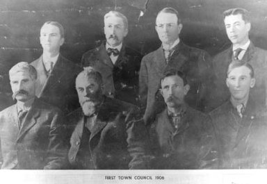
Folder or Collection Name
Cities & Towns - Worland #2 of 2
Image Title
FIRST TOWN COUNCIL, TOP ROW:L-R: E.M. CONANT, C.F. ROBERTSON, E.W. FOSTER, H.B. GATES;BOTTOM ROW: J.H. LAWSON, C.H. WORLAND, H.L. BONINE, J. ASHLEY, HOWELL,1906, P70-117
Coverage or Location
Worland, Wyoming
Date
1906
Folder or Collection Name
Fish, Edna Collection (P91-9)
Image Title
CHEYENNE'S CAPITOL BUILDING
Coverage or Location
Cheyenne, Wyoming
Date
1906
Folder or Collection Name
Frison Collection (P82-57)
Image Title
HOLE-IN-THE-WALL, MAN CARRYING RIFLE AND LEADING PACK HORSE AND SECOND PHOTO OF MEN, HORSES AND WAGON ON ROAD
Coverage or Location
Unknown
Date
1906
Folder or Collection Name
Heald Collection (P74-22)
Image Title
VIEW OF CITY ACROSS MAIN STREET CLOSE TO LITTLE GOOSE BRIDGE
Coverage or Location
Sheridan, Wyoming
Date
1906
Folder or Collection Name
Hole in the Wall
Image Title
UNIDENTIFIED MEN ON HORSEBACK CROSSING A CREEK GOING TOWARDS A HILLSIDE (2 PHOTOS)
Coverage or Location
Wyoming
Date
1906
Folder or Collection Name
Hole in the Wall
Image Title
2 UNIDENTIFIED MEN STANDING IN THE MIDDLE OF THE RIVER WITH THE WHITE WATER RAPIDS RUNNING OVER SOME ROCKS - HOLE IN THE WALL (2 PHOTOS)
Coverage or Location
Wyoming
Date
1906
Folder or Collection Name
Military Organizations - US Army - ca 1861-1914
Image Title
NO. 180-SCENE COMMON OCCURRENCE AROUND ARMY POSTS SINCE THE CANTENE WAS ABOLISNED.
Coverage or Location
Unknown
Date
1906
Folder or Collection Name
Postcards - Cities & Towns - Wyoming
Image Title
VIEW OF HOUSE IN FORGROUND WITH LARGER BUILDINGS IN BACKGROUND LOOKING NORTH, B/W.
Coverage or Location
Casper, Wyoming
Date
1906
Folder or Collection Name
Postcards - Houses - Wyoming
Image Title
SOD HOUSE WITH TREES, B/W.
Coverage or Location
Torrington, Wyoming
Date
1906
Folder or Collection Name
Schools - Cheyenne #1 of 3
Image Title
GRADUATING CLASS OF CHEYENNE HIGH SCHOOL
Coverage or Location
Cheyenne, Wyoming
Date
1906
Folder or Collection Name
Stimson Collection
Image Title
CONGREGATIONAL PARSONAGE
Coverage or Location
Unknown
Date
1906
Folder or Collection Name
Stimson Collection
Image Title
DE FOREST TELEGRAPH STATION
Coverage or Location
Unknown
Date
1906
Folder or Collection Name
Stimson Collection
Image Title
UNION PACIFIC DEPOT
Coverage or Location
Oakley, Kansas
Date
1906
Folder or Collection Name
Stimson Collection
Image Title
JOHNSON'S RANCH
Coverage or Location
Ellis, Kansas
Date
1906
Folder or Collection Name
Stimson Collection
Image Title
RAYNSFORD'S RANCH
Coverage or Location
Ellis, Kansas
Date
1906
|