|
REFINE
Browse All : Images of 2 and CD Box 4 RR 1188-CD 206
1-3 of 3
Title
Niobrara County Map
Date
1936-1945
Description
Niobrara County Map by State Mineral Supervisor Pierre LaFleiche, Drafted by HG Lowman includes oil & gas fields, township, range, state land, primary & secondary roads WPA Project 6008 1936, 1945
Category - Type
Map-County/Niobrara
Title
Niobrara County Map
Date
1953
Description
Niobrara County Map by WY Highway Dept, Planning & Research Div, with US Dept of Commence, Bureau of Public Roads includes township, range, roads, drainage, railroads, post offices, schools, Ag exp station. pipe lines, dwellings, towns, 1950 Co Population, 1949 aerial photo 2 sheets
Category - Type
Map-County/Niobrara
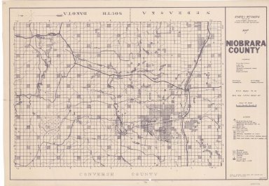
1-3 of 3
|