|
REFINE
Browse All : Images of 8
1-17 of 17
Title
Teton County Map
Date
1937
Description
Teton County Map by State Mineral Supervisor Pierre LaFleiche, drafted by H.G. Lowman includes oil & gas fields, drainage, township, range, state land, primary & secondary roads WPA Project, Blueline, 4 sets, 1 set is taped & cracking
Category - Type
Map-County/Teton
Title
Goshen County Map
Date
1937-1951
Description
Goshen County Map by State Mineral Supervisor Pierre LaFleiche, drafted by HG Lowman includes oil & gas fields, drainage, township, range, state land, primary & secondary roads WPA Project #6999 4/1937, 1945, 1951, 1 set blueline paper, 2 sets vellum
Category - Type
Map-County/Goshen
Title
Teton County Map
Date
1937-1951
Description
Teton County Map by State Mineral Supervisor Pierre LaFleiche, Drafted by HG Lowman includes oil & gas fields, drainage, township, range, state land, primary & secondary roads WPA Project 9/1937, 1946, 1951, 1 set blueline paper, 2 sets vellum
Category - Type
Map-County/Teton
Title
Goshen County Map
Date
1940
Description
Goshen County Map by WY Highway Dept Planning & Research Div, US Dept of Commerce, Bureau of Public Roads includes buildings, air routes, township, range, roads, natural features, drainage, railroads, towns
Category - Type
Map-County/Goshen
Title
Teton County Map
Date
1948
Description
Teton County Map by WY Highway Dept Planning & Research Div, US Dept of Commerce, Bureau of Public Roads includes buildings, air routes, township, range, roads, natural features, drainage, railroads, towns
Category - Type
Map-County/Teton
Title
Goshen County Map
Date
1952
Description
Goshen County Map by WY Highway Dept, Planning & Research Div, with US Dept of Commence, Bureau of Public Roads includes township, range, roads, drainage, railroads, post offices, schools, Ag exp stations, pipe lines, dwellings, towns, 1950 Co Population, 1949 aerial photo 2 sheets
Category - Type
Map-County/Goshen
Title
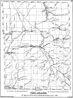
Fort Halleck Map
Date
1959-1960
Description
08 Fort Halleck Map, by LC Bishop, includes townships, ranges, rivers, creeks, roads, trails, pony express stations, graves, stage stations, abandoned railroad stations, 1 sheet vellum, 4 paper copies
Category - Type
Military-Fort Halleck
Title
Teton County Map
Date
1966
Description
Teton County Map by WY Highway Dept, Planning & Research Div, with US Dept of Commence, Bureau of Public Roads includes township, range, roads, drainage, railroads, post offices, schools, Ag exp station, pipe lines, dwellings, towns, 1950 Co population, 1955 aerial photo 2 complete sets with 3 sheets
Category - Type
Map-County/Teton
Title
Sheridan County Airport Master Plan & Administration Building Extension
Date
1950
Description
Sheridan County Airport Master Plan & Administration Building Extension, Federal Project 9-48-008-801
Category - Type
Plan/Specification
Title
Wyoming Territorial Prison Park Drainage Plan-Impervious Areas
Date
1992
Description
WY Territorial Park Drainage Plan-Impervious Areas, job 2478-50, by Banner Assoc, Apr 1992, 1 set with 1 sheet blueline paper
Category - Type
Plan/Specification
Title
Cheyenne Airport - Modification Center No. 10
Date
1942-44
Description
Cheyenne Airport - Modification Center No. 10, Sanitary and storm sewer, night lighting, base map - 6 sheets
Category - Type
Plan
1-17 of 17
|