|
REFINE
Browse All : Images of CD and Wyoming
1-38 of 38
Title
Big Aviation Meet Poster, Cheyenne
Date
1911
Description
Big Aviation Meet Poster, Two Curtis Type Biplanes at Frontier Park, Cheyenne, WY, on 8/1/1911, Charles F. Walsh & Harold S. Brinker demonstration, 1 printed sheet-cardboard with blue printing
Category - Type
Poster-Advertisement
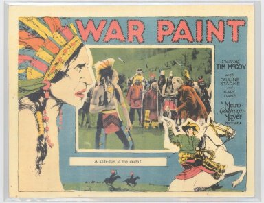
Title
"War Paint" Tim McCoy Movie Poster
Date
1926
Description
Tim McCoy Movie Poster, "War Paint"
Category - Type
Poster-Advertisement
Title
Cheyenne Map
Date
1930
Description
Cheyenne Map includes military reservation, street names, lakes, airport, railroad yard & track alignments, Crow Creek, Hammond Packing, cemeteries, school locations, parks, government boundary line, Dodge boundary line
Category - Type
Map-City/Cheyenne
Title
Cheyenne Map
Date
1930
Description
Cheyenne Map by PR Revis, Cheyenne City Engineer includes lots, blocks, streets, avenues, cemeteries, lakes, airport/aviation field, railroad, creek (Appears to be an election district map) with red lines and blue numbers written on map
Category - Type
Map-City/Cheyenne
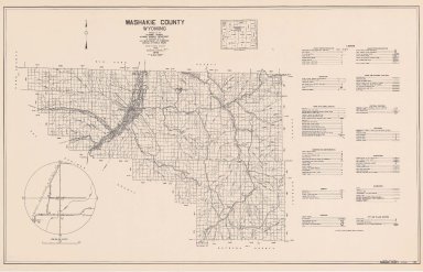
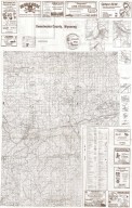
Title
Washakie County Map
Date
1946
Description
Washakie County Map by WY Highway Dept Planning & Research Div, US Dept of Commerce, Bureau of Public Roads includes buildings, air routes, township, range, roads, natural features, drainage, railroads, towns, 2 copies
Category - Type
Map-County/Washakie
Title
Devils Tower National Monument Special Topo Map
Date
1949
Description
Devils Tower National Monument Special Topo Map, by US Department of Interior Geological Survey, includes Township 53, Range 65 - Range 66, types of roads, building locations & names, river and creek, springs, trails, 1 set with 1 sheet colored paper
Category - Type
Map-Nat'l Park
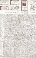
Title
Washakie County Map
Date
1958
Description
Washakie County Map by WY Highway Dept Planning & Research Div, US Dept of Commerce, Bureau of Public Roads includes buildings, air routes, township, range, roads, natural features, drainage, railroads, towns, 1 complete set with 2 sheets
Category - Type
Map-County/Washakie
Title
Wyoming Highway Map-Systems Map State
Date
1977
Description
WY Highway Map-Systems Map State, includes cities, counties, roads, boundaries, Federal aid highways, federal land ownership, lakes, creeks, railroad lines; enlargements of Cheyenne, Casper and Sheridan; general legend, by WY Highway Department Planning Branch in cooperation with the US Transportation Department, Federal Highway Administration
Category - Type
Map-Trail or Road
Title
Cheyenne Downtown Development Authority Mayor's Awards Poster
Date
1987
Description
Mayor's Awards Poster by Cheyenne Downtown Development Authority, Sponsored by the National Endowment for the Arts, includes rendering of the Cheyenne Union Pacific Railroad Depot
Category - Type
Poster-Advertisement
Title
Rawlins street map
Date
1995
Description
Rawlins street map, includes highways, streets, railroad, boundary, index, points of interest, bounded by ads. Reverse side-vicinity map, part of State map, historic scenic loop routes, scenic descriptions, history, recreational activities, schools, highways & transportation, area attractions, land ownership, county boundaries, geographic descriptions, points of interest, parks & recreation
Category - Type
Map-City/Rawlins
Title
Oregon-Mormon Trail in Wyoming's Wind River Country
Date
1997
Description
The Oregon-Mormon Trail in Wyoming's Wind River Country. Schematic trails map inc roads, interpretive sites, visitor info, camping, mountains, continental divide, Sweetwater River, suggestions for travel, city locations all on Side 1. Side 2 inc summer events for 1997 hosted by various groups, historical & genealogical info, businesses that provide for rides on the Oregon-Mormon Trail, visitor safety info, area phone numbers
Category - Type
Map-Trail or Road
Title
Downtown Cheyenne Shopping, Dining & Services Map
Date
1998
Description
Downtown Cheyenne Shopping, Dining & Services Map. Side 1 reference map inc roads and streets, airport, Cheyenne area attractions. Side 2 inc downtown street map, index of attractions, business by location on street, parking facility, automated teller, place to worship, public phones, public restrooms, mailbox, bus stop, trolley stop
Category - Type
Map-City/Cheyenne
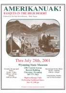
Title
"Amerikanuak! Basques in the High Desert" Poster
Date
2001
Description
Amerikanuak! Basques in the High Desert Poster, photo of Basque Camp, tent, truck, mule, two men & a woman, mountain background, dates of exhibit, includes info re. Bighorn Basque Club dance performance
Category - Type
Poster-Advertisement
Title
"Protecting Wyoming's Sacred Places" Wyoming Archaeology Awareness Month Poster
Date
2001
Description
Wyoming Archaeology Awareness Month - September 2001, Protecting Wyoming's Sacred Places Poster, includes 1903 photo by J.E. Stimson, reflection of Devil's Tower in river bottom, of Devil's Tower surrounded by native American printed language. Image use concurred by Consulting Tribes of Bear Lodge. Sponsored by Wyoming State Historic Preservation Office, BLM, Wyoming Transportation Department, State Archaeology Office, National Park Service, Wyoming Business Council, UW, among others. 9 copies
Category - Type
Poster-Advertisement
Title
Wyoming Historic Trails Map
Date
2003 Circa
Description
WY Historic Trails Map, US Department of Interior, Bureau of Land Management, historic sites, trail routes, map scale, topography, State and Interstate Highways, water courses, lakes and reservoirs, city locations, historic trail descriptors (1840-1900), photos by Randall K. Wagner unless noted, legend, continental divide, 3 sets with 1 sheet
Category - Type
Map-State
Title
A Bridge to the Past, WY Archives Week
Date
2005
Description
A Bridge to the Past, WY Archives Week, Oct 24-28, 2005. Poster, includes Fort Steele Bridge under Construction photo by J.E. Stimson 1901. Description of the annual event including numerous sponsors names
Category - Type
Poster-Advertisement
Title
Basque Sheepherders of Wyoming. Poster of presentation
Date
2005
Description
The Basque Sheepherders of Wyoming. Poster of presentation by David Romtvedt, includes image of sheep, description of presenter, date, sponsors. 2 sets
Category - Type
Poster-Advertisement
Title
Sharing Memories, Archives Month, October 2005 Poster,
Date
2005
Description
Sharing Memories, Archives Month, October 2005 Poster, includes historic cowboy photo from Charles J. Belden Collection, names of the WY State Historical Records Advisory Board members & the services it provides. Graphic design by Vicki Schuster.
Category - Type
Poster-Advertisement
Title
"Hello History, Helping you make the connection produced by,," WY Archives Month Poster
Date
2006
Description
WY Archives Month Poster, October 2006, "Hello History, Helping you make the connection produced by,,," promoting the preservation of documentary history & honoring our cultural heritage. Numerous organization sponsorship, WY State Parks & Cultural Resources includes 1906 JE Stimson photo of telephone operators, 2 sets with 1 sheet colored paper
Category - Type
Poster-Advertisement
Title
Centennial of the Antiquities Act Poster, 1906-2006, Devils Tower, America's First National Monument WY Archaeology Awareness Month
Date
2006
Description
WY Archaeology Awareness Month, Centennial of the Antiquities Act Poster, 1906-2006, Devils Tower, America's First National Monument, includes Devils Tower photo from ca 1920 (photographer unknown), sponsored by multiple state & federal agencies, Photo courtesy of Devils Tower Natural History Association, Graphic design by Elizabeth Ono Rahel, 1 set with 1 colored sheet paper
Category - Type
Poster-Advertisement
Title
Wyoming Highway Map
Date
2006
Description
WY Highway Map by Public Affairs Office of the WY Transportation Department includes highways & interstates, city map blow-ups, mountain ranges, roads, county boundaries, rivers & streams, lakes & reservoirs, location names, historic descriptions, railroads, historic trails, legend & index, statewide recreation site listings by agency administrator, general tourist info, road & weather condition access info, 3 sets with 1 double-sided colored paper
Category - Type
Map-State
Title
Wyoming History Day Poster
Date
2006
Description
Wyoming History Day 2006 Poster, describes year-long education program, description of Grace Raymond Hebard, workshop & contest dates, information request details, historic photo of canvas covered wagon with occupant prepared to shoot at unknown object; coordinated by American Heritage Center at the University of Wyoming, sponsored by Wyoming State Historical Society, Wyoming State Parks & Cultural Resources.
Category - Type
Poster-Advertisement
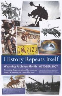
Title
"History Repeats Itself" Wyoming Archives Month Poster
Date
2007
Description
WY Archives Month Poster, October 2007, "History Repeats Itself, 2 sets with 1 sheet colored paper
Category - Type
Poster-Advertisement
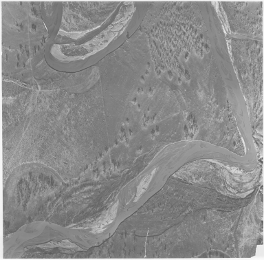
Title
Aerial Photo of Military Site, possibly Fort Reno
Date
Undated
Description
Aerial Photo of Military Site, possibly Fort Reno
Category - Type
Military-Fort Reno
Title
Casper city map and environs
Date
Undated
Description
Casper city map and environs, includes public buildings, points of interest, recreational areas & facilities, school index, advertisers index, North Platte River, railroad lines, small map of State with-counties, highways, cities, geographic locations, State lines, Wardwell Extension & Bar Nunn, Airport Extension. Double sided.
Category - Type
Map-City/Casper
Title
Cool It Big Wyoming poster
Date
Undated
Description
Cool It Big Wyoming-colored poster with late fall snow scene, geyser, antlered bull elk, snow, forest
Category - Type
Poster-Advertisement
Title
Encounter Big Wyoming, Devils Tower National Monument poster
Date
Undated
Description
Encounter Big Wyoming, Devils Tower National Monument poster, includes summer scene, weathered building & Devils Tower
Category - Type
Poster-Advertisement
Title
Green River Street Map & Tour Guide
Date
Undated
Description
Green River Street Map & Tour Guide, includes historic sites & points of interest, Flaming Gorge map, recreation site info, roads, state line, recreation activity photos, loop tours, street names & locations, Green River, municipal wards, government building locations, parks, State & Interstate Highways
Category - Type
Map-City/Green River
Title
Sweetwater County Map
Date
Undated
Description
Sweetwater County Map. Advertisers, includes roads & roadway features, structures, railroads, drainages, natural features, boundaries, city & town centers, airways, public service & educational facilities, farm units, dwellings, forts, armory, pack or foot trail historic trail with name, coordinate points, triangulation stations, industrial sites, conservation & recreations sites, water bodies, river/stream drainages, 1/2 county map on each side.
Category - Type
Map-County/Sweetwater
Title
Wyoming State Historical Society/Chapters Logos, hand drawn
Date
Undated
Description
Wyoming State Historical Society/Chapters Logos, hand drawn
Category - Type
Poster-Advertisement
1-38 of 38
|