|
REFINE
Browse All : Images of Cheyenne and Wyoming and Laramie County and Digital
1-8 of 8
Title
Dodge Plat of Cheyenne
Date
1868 Circa
Description
Dodge Plat of Cheyenne, poor quality original
Category - Type
Map-City/Cheyenne
Title
Woman's Suffrage Session Law, Woman's Suffrage Act, Council Journal entry
Date
1869
Description
Woman's Suffrage Session Law, Woman's Suffrage Act, Council Journal entry
Category - Type
Misc
Title
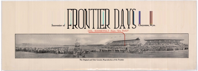
"Col. Roosevelt says it's Bully" Cheyenne Frontier Days poster
Date
1903 Circa
Description
Poster-Souvenir of Frontier Days, "Col. Roosevelt says it's Bully," the original & only genuine reproduction of the Frontier, includes a panoramic group photo with the grandstands & judging tower---scan distorted
Category - Type
Poster-Advertisement
Title
Cheyenne City Street Index
Date
1999
Description
Cheyenne City Street Index, includes street name, address hundred block and the map location
Category - Type
Map-City/Cheyenne
Title
Cheyenne Map-Middle east portion of City from Airport runways/Holliday Park to Whitney Road area, and Dell Range area to Crow Creek Wastewater Treatment Plant area
Date
1999
Description
Cheyenne Map-Middle east portion of City from Airport runways/Holliday Park to Whitney Road area, and Dell Range area to Crow Creek Wastewater Treatment Plant area, includes streets & roads, addresses, Highway 30, Schools, Priarie View Golf Course, Brimmer Park, Cahill Park Soccar Complex, Baseball Complexes, United Medical Center-East, railroad tracks, Norris Viaduct, Fire Station No 5, Crow Creek & Dry Creek
Category - Type
Map-City/Cheyenne
Title
Cheyenne Map-Northeast portion of City from Dell Range to Wrangler Road, and James Drive to Astronaut Drive
Date
1999
Description
Cheyenne Map-Northest portion of City from Dell Range to Wrangler Road, and James Drive to Astronaut Drive, includes streets & roads, addresses, water tank, Fire Station No 5, Anderson School, Childs Creek and Dry Creek
Category - Type
Map-City/Cheyenne
Title
Cheyenne Grizzlies baseball team poster
Date
2005
Description
Cheyenne Grizzlies baseball team poster, includes game schedule and sponsor advertisements, 1 sheet colored paper---Scanned for Wyoming State Museum, poster is NOT in Historic Map Collection
Category - Type
Poster-Advertisement
1-8 of 8
|


