|
Title
Western Trails Digitization Project Trail Records
Date
[1840 circa, 2005]
Description
Western Trails Digitization Project, 8/12/3005, acces & thumbnail scans, includes scans & corresponding metadata of Trail Records from all WY Dept of State Parks & Cultural Resources Programs (DUPLICATE ENTRY)
Category - Type
Map-Trail or Road
Title
Western Trails Digitization Project, Trail Records
Date
[1840 circa, 2005]
Description
Western Trails Digitization Project, 8/12/3005, acces & thumbnail scans, includes scans & corresponding metadata of Trail Records from all WY Dept of State Parks & Cultural Resources Programs
Category - Type
Letter
Title
US Map by Cram (published 1901)
Date
1845-1860
Description
US Map by Cram (published 1901), digital only copy
Category - Type
Map-US
Title
US Map by Cram (published 1901)
Date
1855-1898
Description
US Map by Cram (published 1901), digital only copy
Category - Type
Map-US
Title
Johnson's Map of Minnesota & Dakota
Date
1862
Description
Johnson's Map of Minnesota & Dakota, digital only copy
Category - Type
Map-Regional
Title
Johnson's Map of Nebraska, Dakota, Montana & Kansas
Date
1862
Description
Johnson's Map of Nebraska, Dakota, Montana & Kansas, digital only copy
Category - Type
Map-Regional
Title
Johnson's Map of Washington & Oregon
Date
1862
Description
Johnson's Map of Washington & Oregon, digital only copy
Category - Type
Map-Regional
Title
Johnsons Map of Territories for New Mexico & Utah
Date
1862
Description
Johnsons Map of Territories for New Mexico & Utah, C-1318, digital only
Category - Type
Map-Regional
Title
Dodge Plat of Cheyenne
Date
1868 Circa
Description
Dodge Plat of Cheyenne, poor quality original
Category - Type
Map-City/Cheyenne
Title
Woman's Suffrage Session Law, Woman's Suffrage Act, Council Journal entry
Date
1869
Description
Woman's Suffrage Session Law, Woman's Suffrage Act, Council Journal entry
Category - Type
Misc
Title
Esther Morris' Justice of the Peace Docket-Carter/Sweetwater County
Date
1870
Description
Esther Morris' JP Docket-Sweetwater County
Category - Type
Misc
Title
Historical Map of the US, drawn to illustrate the American Constitution
Date
1872
Description
Historical Map of the US, drawn to illustrate the American Constitution, edited by Franklin B Hough, includes existing states and territories, editorial/informational comments concerning the regions (Wyoming is not shaped correctly)
Category - Type
Map-US
Title
Rock Springs Exposer, 11/10/1876
Date
1876
Description
Rock Springs Exposer, Volume XIX, 11/10/1876
Category - Type
Newspaper
Title
Rock Springs Exposer, 11/10/1876
Date
1876
Description
Rock Springs Exposer, Volume XIX, 11/10/1876
Category - Type
Newspaper
Title
Survey Map Township 33, Range 80, Sections 1 - 36
Date
1883
Description
Survey Map by Edw. C David, surveyed by Wm O. Owen, Downey & Grant, US Surveyor General's Office, printed-A Gast & Co, Township 33, Range 80, Sections 1 - 36, includes topo info, North Platte River, ranch, roads, creeks, total number of acres, dates of contracts, amount of surveys, magnetic declination, set with 1 sheet paper
Category - Type
Map-Survey
Title
Charles Guernsey Mining Claims in the Canon Mining District survey date, patent date, (Sunrise Mine)
Date
1892 Circa
Description
Charles Guernsey Mining Claims in the Canon Mining District, Township 27 Range 65 & 66, Township 28, Range 67, includes mine name & boundary, survey number, table-with lode name, date, survey date, patent date, blueprint (loaned for copy by Homesteader Museum)
Category - Type
Map-Mineral
Title
Survey Map Township 36 Range 94, Sections 1 - 36
Date
1893
Description
Survey Map by Wm A. Richards, surveyed by Coleman & Gilcrest, US Surveyor General's Office, Township 36, Range 94, Sections 1 - 36, includes topo info, roads, creeks, total number of acres, dates of contracts, amount of surveys, magnetic declination, 1 set with 1 sheet paper
Category - Type
Map-Survey
Title
Survey Map Township 41, Range 107, Sections 1 - 4 9 -10
Date
1893
Description
Survey Map by Wm A. Richards, surveyed by Carpenter & Warner, US Surveyor General's Office, Township 41, Range 107, Sections 1 - 4 , 9 -10, includes topo info, ditches, trails, creeks,rivers, total number of acres, dates of contracts, amount of surveys, , 1 set with 1 sheet paper
Category - Type
Map-Survey
Title
North Platte Watershed-North Platte Cooperative Investigation map
Date
1897
Description
Map Showing Watersheds of Principal Streams Arid Sections of the US, includes the Trans-Mississippi West, southern portion of British Possession, northern Mexico, rivers & creeks, Gulf of Mexico, lakes, deserts---To accompany report on examination of reservoir sites in Wyoming & CO, dated 11/6/1897 by Capt ? Chittenden, H DOC 141 55 2
Category - Type
Map-Water
Title
US Map by Cram (published 1901)
Date
1898-1901
Description
US Map by Cram (published 1901), digital only copy
Category - Type
Map-US
Title
Statistical Charts from atlas by Cram
Date
1901
Description
1901 Statistical charts p 290-291 Crams Unrivaled Family Atlas of the World Indexed, C-1409, digital only
Category - Type
Misc
Title
Statistical Charts from atlas by Cram
Date
1901
Description
1901 Statistical charts p 288-289 Crams Unrivaled Family Atlas of the World Indexed, C-1409, digital only
Category - Type
Misc
Title
Wyoming Info page from atlas by Cram
Date
1901
Description
1901 Wyoming Info page 389 Crams Unrivaled Family Atlas of the World Indexed, C-1409, digital only
Category - Type
Misc
Title
Wyoming Map by Cram
Date
1901
Description
WY Map by Cram, digital only copy
Category - Type
Map-WY
Title
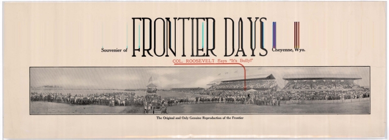
"Col. Roosevelt says it's Bully" Cheyenne Frontier Days poster
Date
1903 Circa
Description
Poster-Souvenir of Frontier Days, "Col. Roosevelt says it's Bully," the original & only genuine reproduction of the Frontier, includes a panoramic group photo with the grandstands & judging tower---scan distorted
Category - Type
Poster-Advertisement
Title
Marriage Certificate-Weick (from Minnesota)
Date
1904
Description
Marriage Certificate-Weick (from Minnesota), loaned for copy
Category - Type
Certificate-Marriage
Title
Colorado Topo Map ranges 69 - 72
Date
1909
Description
Colorado Topo Map by US Geological Survey, includes ranges 69 - 72, townships 6 - 12, rivers & creeks, ranch names, railroad, Medicine Bow National Forest, mountains, bluffs & hills, 1 partial sheet paper-colored
Category - Type
Map-Topo
Title
Colorado Topo Map ranges 69 - 72
Date
1909
Description
Colorado Topo Map by US Geological Survey, includes ranges 69 - 72, townships 6 - 12, rivers & creeks, ranch names, railroad, Medicine Bow National Forest, mountains, bluffs & hills, 1 partial sheet paper-colored
Category - Type
Map-Topo
Title
Crane Quad Map Moffat County, CO map
Date
1913-1914
Description
Crane Quad Map Moffat County, CO, (page 111), includes topo info, roads, rivers & creeks, divides, gulches, cities & towns, annotation re. possible site of 4th Infantry
Category - Type
Map-Topo
Title
Map to accompany application for enlargement of J.F.W. Ditch application
Date
1916
Description
Map to accompany application for enlargement of J.F.W. Ditch application by Roy Spague, map by Nowell-Atherly Co, includes Township 51, Ranges 94, 95, 96, tracts, lots, school section, ditch, Greybull River, 1 color coded sheet-- (Loaned for copy)
Category - Type
Map-Water
Title
Sunset, Duke, Hope, Chestnut Lode Claims map plus amended Westover Lode
Date
1923
Description
Sunset, Duke, Hope, Chestnut Lode Claims map plus amended Westover Lode, includes Township 27, Range 66, Section 24, lode names and boundaries (loaned for copy by Homesteader Museum)
Category - Type
Map-Mineral
Title
Indian Petroleum Corp, Ferris Field Map Township 25 - 26, Ranges 86 - 87
Date
1928
Description
Indian Petroleum Corp, Ferris Field Map, includes Township 25 - 26, Ranges 86-87, location of pipelines, roads, land ownership, 1 map with 1 sheet paper
Category - Type
Map-Survey
Title
"They Keep 'Em Rolling The Railroads are the Backbone of Offense" railroad Poster
Date
1944
Description
Railroad Poster, published by the Union Pacific Railroad, loaned for scanning by Jim Ehrenberger for WY State Museum exhibit. Includes the following text: Throug Snow.Sleet.Rain.Fog "They Keep 'Em Rolling" The Railroads are the Backbone of Offense. Listed to "Your America" on Your Favorite NBC Station Every Saturday 5 P.M. Eastern War Time (Loaned for Copy)
Category - Type
Poster-Advertisement
Title
"They Keep 'Em Rolling" The Railroads are the Backbone of Offense, railroad poster
Date
1944
Description
Railroad Poster, published by the Union Pacific Railroad, loaned for scanning by Jim Ehrenberger for WY State Museum exhibit. Includes the following text: Sentinels of Safety, the Signal Man. "They Keep 'Em Rolling" The Railroads are the Backbone of Offense (Loaned for Copy)
Category - Type
Poster-Advertisement
Title
Lander's Road through Bridger National Forest Map
Date
1960
Description
Lander's Road through Bridger National Forest Map by US Department of Agriculture, Forest Service includes townships, ranges, cities, towns, rivers, creeks, railroad, highways, roads, ranger stations, mines, campgrounds, picnic areas, landmarks, cabins, buildings, power lines, trails
Category - Type
Map-Forest/Bridger
Title
East & West Study Area Maps Land Utilitzation Area Townships 35 - 49, Ranges 65 - 68, 73 - 77
Date
1960s
Description
East & West Study Area Maps Land Utilitzation Area, includes Townships 35 - 49, Ranges 65 - 68, 73 - 77, cities & towns, reservoirs, highways, roads, creeks, oil fields, generating plant, cnals, dams, wells, windmills, corrals, cropland, transmission line , pipelines, angostura area drainage, National Forests
Category - Type
Map-Site
Title
Union Pacific Railroad map 1868 Grade
Date
1971
Description
Map of the Union Pacific Railroad 1868 Grade by Paul & Helen Henderson, includes Townships 12 - 16, Ranges 116 - 121, railroad, trails, creeks, springs, tunnels, highways
Category - Type
Map-Trail or Road
Title
Eastern District, Nebraska Division map
Date
1978
Description
Map of Eastern District, Nebraska Division corrected 9/13/1978, includes routes (possibly railroad), cities & towns, rivers, portions of KS, CO & WY
Category - Type
Map-Regional
Title
Union Pacific Railroad Route map, (South Eastern WY)
Date
1978 Circa
Description
Map of the Union Pacific Route, (South Eastern WY) includes original M.L.-1868, 2nd M.T.-1901 and 3rd M.T.-1953, Ranges 62 - 80 railroad tracks, cities & towns, creeks & reservoirs
Category - Type
Map-Railroad
Title
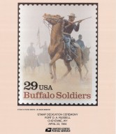
Buffalo Soldier 29 Cent Stamp Dedication Poster, held at Fort Russell on April 23, 1994
Date
1994
Description
Buffalo Soldier 29 Cent Stamp Dedication Poster, held at Fort Russell on April 23, 1994, includes image of Buffalo Soldier on horse holding rifle in foreground with additional soldiers faded in the background, 1 set with 1 sheet colored---loaned for scan
Category - Type
Poster-Advertisement
Title
Cheyenne City Street Index
Date
1999
Description
Cheyenne City Street Index, includes street name, address hundred block and the map location
Category - Type
Map-City/Cheyenne
Title
Cheyenne Map-Middle east portion of City from Airport runways/Holliday Park to Whitney Road area, and Dell Range area to Crow Creek Wastewater Treatment Plant area
Date
1999
Description
Cheyenne Map-Middle east portion of City from Airport runways/Holliday Park to Whitney Road area, and Dell Range area to Crow Creek Wastewater Treatment Plant area, includes streets & roads, addresses, Highway 30, Schools, Priarie View Golf Course, Brimmer Park, Cahill Park Soccar Complex, Baseball Complexes, United Medical Center-East, railroad tracks, Norris Viaduct, Fire Station No 5, Crow Creek & Dry Creek
Category - Type
Map-City/Cheyenne
Title
Cheyenne Map-Northeast portion of City from Dell Range to Wrangler Road, and James Drive to Astronaut Drive
Date
1999
Description
Cheyenne Map-Northest portion of City from Dell Range to Wrangler Road, and James Drive to Astronaut Drive, includes streets & roads, addresses, water tank, Fire Station No 5, Anderson School, Childs Creek and Dry Creek
Category - Type
Map-City/Cheyenne
Title
Cheyenne Grizzlies baseball team poster
Date
2005
Description
Cheyenne Grizzlies baseball team poster, includes game schedule and sponsor advertisements, 1 sheet colored paper---Scanned for Wyoming State Museum, poster is NOT in Historic Map Collection
Category - Type
Poster-Advertisement
Title
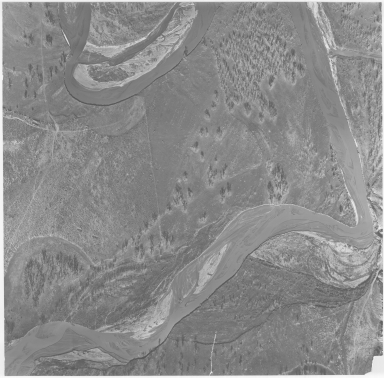
Aerial Photo of Military Site, possibly Fort Reno
Date
Undated
Description
Aerial Photo of Military Site, possibly Fort Reno
Category - Type
Military-Fort Reno
Title
Cody Canal - WY
Date
Undated
Description
Cody Canal - WY from WY Department of Public Land's Carey Act project file, includes Townships 100, 101, 102 & 103, Ranges 51, 52, 53, Shoshone River, location of canal, lateral, creeks, town of Cody, 1 set with 1 sheet paper
Category - Type
Map-Water
Title
Fort Fetterman Vicinity Map
Date
Undated
Description
Fort Fetterman Vicinity Index Map showing location, owner, & brand of ranches during frontier town--a settlement pattern
Category - Type
Military-Fort Fetterman
Title
Pony Express Route Map
Date
Undated
Description
Pony Express Route Map, includes only route, stops, distance between stops, two unnamed rivers, possibly by LC Bishop
Category - Type
Map-Trail or Road
Title
Pony Express, Trails & Outposts route
Date
Undated
Description
Route of the Pony Express, Trails & Outposts established by soldiers, traders, trappers & homeseekers in ther great task of opening the last American frontier, by Geroge Gray, Pony Express Barn, Hotel Robidoux, American Hotels Corp, includes narrative throughout
Category - Type
Map-Trail or Road
|


