|
Title
Letter from Thomas Morse (written from 100 miles East of Fort Laramie)
Date
1850
Description
Letter from Thomas Morse (written from 100 miles East of Fort Laramie)
Category - Type
Letter
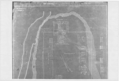
Title
Fort Laramie Guard House Plan
Date
1852
Description
Fort Laramie Guard House Plan, 1 sheet
Category - Type
Military-Fort Laramie
Title
Fort Laramie Officers Quarters Plan
Date
1852
Description
Fort Laramie Officers Quarters Plan
Category - Type
Military-Fort Laramie
Title
Fort Laramie to Cheyenne Pass Map
Date
1858
Description
Fort Laramie to Cheyenne Pass Map, Photostat
Category - Type
Military-Fort Laramie
Title
Fort Laramie Map
Date
1863
Description
Map Fort Laramie 1 laminated? & 1 Photostat
Category - Type
Military-Fort Laramie
Title
Fort Laramie Map
Date
1863
Description
Map Fort Laramie 1 laminated? & 1 Photostat
Category - Type
Military-Fort Laramie
Title
Fort Laramie Survey Map
Date
1866 Circa
Description
Fort Laramie Survey Map
Category - Type
Military-Fort Laramie
Title
Fort Laramie Arsenal & Magazine, Bakery, Company Shops, Trailer-Shop & Kitchen plan
Date
1867
Description
Fort Laramie Arsenal & Magazine, Bakery, Company Shops, Trailer-Shop & Kitchen plan
Category - Type
Military-Fort Laramie
Title
Fort Laramie Barracks, Kitchen & Officers Stables plan
Date
1867
Description
Fort Laramie Barracks, Kitchen & Officers Stables plan
Category - Type
Military-Fort Laramie
Title
Fort Laramie Barracks, Mess Rooms & Kitchens plan
Date
1867
Description
Fort Laramie Barracks, Mess Rooms & Kitchens plan
Category - Type
Military-Fort Laramie
Title
Fort Laramie Carpenters, Wheelrights & Painters Shop, Saddler Shop, Post Office & Blacksmith Shop plan
Date
1867
Description
Fort Laramie Carpenters, Wheelrights & Painters Shop, Saddler Shop, Post Office & Blacksmith Shop plan
Category - Type
Military-Fort Laramie
Title
Fort Laramie Commanding Officers Quarters, Adjutants Office, Officers Quarters plan
Date
1867
Description
Fort Laramie Commanding Officers Quarters, Adjutants Office, Officers Quarters plan
Category - Type
Military-Fort Laramie
Title
Fort Laramie Laundresses Quarters, Farriers Quarters, Ice House, Musicians Quarters, Laborer Quarters plan
Date
1867
Description
Fort Laramie Laundresses Quarters, Farriers Quarters, Ice House, Musicians Quarters, Laborer Quarters plan
Category - Type
Military-Fort Laramie
Title
Fort Laramie Officers Quarters Plan
Date
1867
Description
Fort Laramie Officers Quarters Plan
Category - Type
Military-Fort Laramie
Title
Fort Laramie Provost-Marshalls Office, Guard House, Band Room & Hospital plan
Date
1867
Description
Fort Laramie Provost-Marshalls Office, Guard House, Band Room & Hospital plan
Category - Type
Military-Fort Laramie
Title
Fort Laramie Quartermasters Employee Quarters, Commissary Store House & Teamster Quarters plan
Date
1867
Description
Fort Laramie Quartermasters Employee Quarters, Commissary Store House & Teamster Quarters plan
Category - Type
Military-Fort Laramie
Title
Fort Laramie Quartermasters Office & Storehouses, Commissarys Office & Store House plan
Date
1867
Description
Fort Laramie Quartermasters Office & Storehouses, Commissarys Office & Store House plan
Category - Type
Military-Fort Laramie
Title
Fort Laramie List of Buildings
Date
1871
Description
Fort Laramie List of Buildings, 2 sheets photostatic
Category - Type
Military-Fort Laramie
Title
Fort Laramie List of Buildings
Date
1871
Description
Fort Laramie List of Buildings, 2 sheets photostatic
Category - Type
Military-Fort Laramie
Title
Fort Laramie Site Plan
Date
1871
Description
Fort Laramie Site Plan, 1 sheet photostatic
Category - Type
Military-Fort Laramie
Title
Fort Laramie Post Hospital plan
Date
1873
Description
Fort Laramie Post Hospital plan
Category - Type
Military-Fort Laramie
Title
Fort Laramie Site Plan
Date
1873
Description
Fort Laramie Site Plans, 2 sheets photostatic
Category - Type
Military-Fort Laramie
Title
Fort Laramie Site Plan
Date
1873
Description
Fort Laramie Site Plans, 2 sheets photostatic
Category - Type
Military-Fort Laramie
Title
Fort Laramie Cavalry Stables plan
Date
1876
Description
Fort Laramie Cavalry Stables plan
Category - Type
Military-Fort Laramie
Title
Fort Laramie Site Plan
Date
1876
Description
Fort Laramie Site Plans, 1 sheet photostatic
Category - Type
Military-Fort Laramie
Title
Fort Laramie Site Plan
Date
1881
Description
Fort Laramie Site Plan, 2 sheets photostatic (1852, 1881)
Category - Type
Military-Fort Laramie
Title
Fort Laramie Site Plan
Date
1881
Description
Fort Laramie Site Plan, 2 sheets photostatic (1852, 1881)
Category - Type
Military-Fort Laramie
Title
Fort Laramie Granary plan
Date
1885
Description
Fort Laramie Granary plan
Category - Type
Military-Fort Laramie
Title
Fort Laramie Military Reserve Map
Date
1890
Description
Fort Laramie Military Reserve Map, photostatic
Category - Type
Military-Fort Laramie
Title
Charles Guernsey Mining Claims in the Canon Mining District survey date, patent date, (Sunrise Mine)
Date
1892 Circa
Description
Charles Guernsey Mining Claims in the Canon Mining District, Township 27 Range 65 & 66, Township 28, Range 67, includes mine name & boundary, survey number, table-with lode name, date, survey date, patent date, blueprint (loaned for copy by Homesteader Museum)
Category - Type
Map-Mineral
Title
Fort Laramie Military Reserve description
Date
1897
Description
Fort Laramie Military Reserve Description, 2 photostats
Category - Type
Military-Fort Laramie
Title
Fort Laramie Military Reserve description
Date
1897
Description
Fort Laramie Military Reserve Description, 2 photostats
Category - Type
Military-Fort Laramie
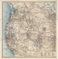
Title
Western United States Map, Guernsey Steel Company Map
Date
1908
Description
Western US Map, Guernsey Steel Company Map includes Pacific with sailing desination distances, state boundaries, mountain relief, lakes & river courses, railroad lines, cities, part of Canada also included for railroad routing purposes, longitude 97-131 degrees, west, latitude 31-53 north. Index of principal railraods is extensive.
Category - Type
Map-Mineral
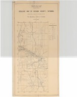
Title
Guernsey & the Hartville Iron District Map
Date
1910 Circa
Description
Guernsey & the Hartville Iron District Map by Frank Bond, Lincoln Land Company includes townships, ranges, railroad, roads, rivers, topographical, type of minerals, drawing of dam site "The New Birmingham of the West"
Category - Type
Map-City/Guernsey
Title
Fort Laramie Site Map
Date
1931
Description
Old Fort Laramie Site Map 2 copies
Category - Type
Military-Fort Laramie
Title
Fort Laramie Site Map
Date
1931
Description
Old Fort Laramie Site Map 2 copies
Category - Type
Military-Fort Laramie
Title
Fort Laramie Map
Date
1935
Description
Fort Laramie Map 2 copies
Category - Type
Military-Fort Laramie
Title
Fort Laramie Map
Date
1935
Description
Fort Laramie Map 2 copies
Category - Type
Military-Fort Laramie
Title
Goshen County Geologic Map
Date
1936
Description
Goshen County Geologic Map by Geological Survey of WY, Arthur M Morgan, from WY State Planning Board/WY State Planning & Water Conservation Board records, includes townships & ranges, cities & towns, rivers & creeks, highway, railroad, formations, 1 set with 1 sheet blueline paper
Category - Type
Map-County/Goshen
Title
Goshen County Map
Date
1937-1951
Description
Goshen County Map by State Mineral Supervisor Pierre LaFleiche, drafted by HG Lowman includes oil & gas fields, drainage, township, range, state land, primary & secondary roads WPA Project #6999 4/1937, 1945, 1951, 1 set blueline paper, 2 sets vellum
Category - Type
Map-County/Goshen
Title
Goshen County Map
Date
1940
Description
Goshen County Map by WY Highway Dept Planning & Research Div, US Dept of Commerce, Bureau of Public Roads includes buildings, air routes, township, range, roads, natural features, drainage, railroads, towns
Category - Type
Map-County/Goshen
Title
Guernsey Quadrangle Map
Date
1950
Description
Guernsey Quadrangle Map by US Geological Survey from 1948 ariel photos, includes portions of Platte & Goshen Counties, townships 26-28, ranges 65-66, rivers & creeks, railroads, ranches wells, roads & highways, topographic info, oil wells, 1 set with 1 sheet color-coded linen backed paper
Category - Type
Map-Topo
Title
Glendo City Map
Date
1951
Description
Glendo City Map by WY Highway Dept, Planning Div in cooperation with US Dept of Commerce, Bureau of Public Roads includes US & State highways, lots, blocks, streets, city boundaries, railroads, post office, school, water pipes, 1 vellum
Category - Type
Map-City/Glendo
Title
Glendo Sub-Area of the North Platte River Basin, Wyoming Land Use Suitability and Proposed Adjustment map
Date
1951
Description
Glendo Sub-Area of the North Platte River Basin, Wyoming Land Use Suitability and Proposed Adjustment by US Dept of Interior, Bureau of Land Management, Land Planning Div, includes townships, ranges, forest and district boundaries, roads, railroad, mines, oil & gas wells, buildings, pipelines, reservoirs, 2 copies color coded paper map
Category - Type
Map-Site
Title
Hell Gap Quadrangle Map
Date
1951
Description
Hell Gap Quadrangle Map by US Geological Survey from 1948 ariel photos, includes portions of Platte & Goshen Counties, Guernsey & Sunrise, townships 28-29, range 69, rivers & creeks, railroads, ranches wells, roads & highways, topographic info, oil wells 1 set with 1 sheet color-coded linen backed paper
Category - Type
Map-Topo
Title
Goshen County Map
Date
1952
Description
Goshen County Map by WY Highway Dept, Planning & Research Div, with US Dept of Commence, Bureau of Public Roads includes township, range, roads, drainage, railroads, post offices, schools, Ag exp stations, pipe lines, dwellings, towns, 1950 Co Population, 1949 aerial photo 2 sheets
Category - Type
Map-County/Goshen
Title
Goshen County Map
Date
1952
Description
Goshen County Map by WY Highway Dept, Planning & Research Div, with US Dept of Commence, Bureau of Public Roads includes township, range, roads, drainage, railroads, post offices, schools, Ag exp stations, pipe lines, dwellings, towns, 1950 Co Population, 1949 aerial photo 2 sheets
Category - Type
Map-County/Goshen
|