|
REFINE
Browse All : Images of Wyoming and AS Map Case D, Drawer 14 and Map-C
1-5 of 5
Title
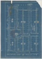
Casper Zoning Map
Date
1904
Description
Casper Map, includes lots & blocks, streets & avenues, North Platte River, railroad tracks, Depot Grounds-Wyoming Central Railway, 1 set with 1 sheet blueprint
Category - Type
Map-City/Casper
Title
Cheyenne Experiment Farm Map
Date
1907
Description
Cheyenne Experiment Farm Map, by US Dept of Agriculture, Office of Experiment Stations, includes, types of crops, locations of wells, evaporation tanks, reservoir, roads, railroad, 1 set with 1 sheet blueprint
Category - Type
Map-Site
Title
Fort DA Russell Partial Plat,
Date
1910
Description
Fort DA Russell Partial Plat, showing Proposed Sidewalks, Roads & Grading, by the Constructing Quartermaster Office, includes building designations & names, grades, crossing types, proposed building sites, culverts, 1 set with 1 sheet blueprint
Category - Type
Military-Fort DA Russell
Title
French Creek & Johnson Creek-lands irrigated by map
Date
1930
Description
French Creek & Johnson Creek-lands irrigated by map, by Floyd M Roush, WY State Engineer Office, includes Township 50 - 51, Range 82 - 84, sections, creeks, designations of lands having water rights & lands having a supplemental water supply, 1 set with 1 sheet blueprint
Category - Type
Map-Water
Title
Post/Fort McKinney Plat
Date
Undated
Description
Post/Fort McKinney Plat, includes building designations, type & list, ditches, roads, fence, sidewalk, sewer & water pipes, topo info, river, 1 set with 1 sheet blueprint
Category - Type
Military-Fort McKinney
1-5 of 5
|