|
REFINE
Browse All : Images of Wyoming and RR Map Case 02A Drawer 03
1-39 of 39
Title
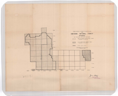
Cheyenne National Forest map
Date
1908
Description
Cheyenne National Forest by US Dept of Agriculture, US Forest Service, includes Crow Creek National Forest boundaries, townships, ranges, sections
Category - Type
Map-Forest/Cheyenne
Title
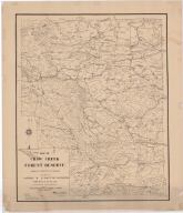
Crow Creek Forest Reserve Map
Date
1908
Description
Crow Creek Forest Reserve Map Albany County, Maneuver Ground by 3rd Battalion of Engineers, PS Bond, EJ Atkinson, includes mountains, cabin, cities, towns, ranches, passes, roads, dams, building locations, contours, linen, colored
Category - Type
Map-Forest/Crow Creek
Title
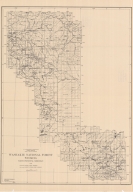
Washakie National Forest Map
Date
1919
Description
Washakie National Forest Map by US Agriculture Dept, Forest Service, HE Sealing, traced by HF Hedge, includes boundaries, townships, ranges, rivers, creeks, lakes, reservoirs, mountains, passes, ranches, 2 copies, 1 oversized (same as map 124)
Category - Type
Map-Forest/Washakie
Title
Washakie National Forest Map
Date
1919
Description
Washakie National Forest Map by US Agriculture Dept, Forest Service, HE Sealing, traced by HF Hedge, includes boundaries, townships, ranges, rivers, creeks, lakes, reservoirs, mountains, passes, ranches, 2 copies, 1 oversized (same as map 126)
Category - Type
Map-Forest/Washakie
Title
Shoshone National Forest Map
Date
1921
Description
Shoshone National Forest Map by US Agriculture Dept, Forest Service, John Burgess, traced by AC Jacquith, includes boundaries, townships, ranges, sections, rivers, creeks, mountains, plateaus, meadows, 1 paper copy
Category - Type
Map-Forest/Shoshone
Title
Shoshone National Forest Map
Date
1921-1928
Description
Shoshone National Forest Map by US Agriculture Dept, Forest Service, US Geological Survey, John Burgess, traced by AC Jacquith, 1921 rev 1927, rev 1928, trapping territories with names written on map, includes boundaries, townships, ranges, sections, rivers, creeks, reservoirs, lakes, mountains, mining regions, railroad, colored, 1 sheet
Category - Type
Map-Forest/Shoshone
Title
Washakie National Forest Map
Date
1926
Description
Washakie National Forest Map by US Dept of Agriculture, Forest Service, WB Greeley, includes townships, ranges, cities, towns, rivers, creeks, railroad, highways, roads, ranger stations, mines, campgrounds, picnic areas, landmarks, cabins, buildings, power lines, trails, 1 oversized copy & 1 blueline paper copy
Category - Type
Map-Forest/Washakie
Title
Washakie National Forest Map
Date
1927
Description
Washakie National Forest Map by US Forest Service, includes boundaries, townships, ranges, rivers, creeks, mountains, cities, towns, mileage chart, houses, buildings, glaciers, headquarters, on back---photos, history, rules & description, 1 colored copy
Category - Type
Map-Forest/Washakie
Title
Shoshone National Forest Map
Date
1929
Description
Shoshone National Forest Map by US Forest Service. includes townships & ranges, rivers & creeks, mountains, cities & towns, forest boundaries, mileage chart, sawmill, trails, railroads, houses, buildings, headquarters, 2 colored copies on back---photos, history, rules & description
Category - Type
Map-Forest/Shoshone
Title
Big Horn Mountains Region Map
Date
1932
Description
Big Horn Mountains Region Map by US Forest Service, includes townships & ranges, rivers & creeks, mountains, cities & towns, forest boundaries, mileage chart, trails, railroads, campgrounds, headquarters, on back---photos, history, rules & description, 1 sheet paper
Category - Type
Map-Forest/Big Horn
Title
Targhee National Forest Map
Date
1932
Description
Targhee National Forest Map by US Forest Service. includes townships & ranges, rivers & creeks, mountains, cities & towns, forest boundaries, mileage chart, sawmill, trails, railroads, houses, buildings, headquarters, 2 colored copies on back---photos, history, rules & description
Category - Type
Map-Forest/Targhee
Title
Washakie National Forest Map
Date
1933
Description
Washakie National Forest Map by US Forest Service, includes boundaries, townships, ranges, rivers, creeks, mountains, cities, towns, mileage chart, houses, buildings, game preserve, headquarters, on back---photos, history, rules & description, 1 set with 1 sheet color coded paper
Category - Type
Map-Forest/Washakie
Title
Ashley National Forest Map
Date
1934
Description
Ashley National Forest Map by US Dept of Agriculture, US Forest Service, includes portions of WY and UT, forest boundaries, townships, ranges, sections, highways, roads, trails, railroads, telephone lines, ranger stations, buildings, rivers, creeks, on back---photos, history, rules & description, 1 sheet paper
Category - Type
Map-Forest/Ashley
Title
Teton National Forest Map
Date
1934
Description
Teton National Forest Map by US Dept of Agriculture, US Forest Service, includes boundaries, townships, ranges, roads, trails, telephone lines, ranger stations, campgrounds, houses, buildings, 1 sheet blueline paper
Category - Type
Map-Forest/Teton
Title
Targhee & Teton National Forest Map
Date
1936
Description
Targhee & Teton National Forest Map by US Forest Service, includes boundaries, townships, ranges, highways, roads, trails, railroads, campgrounds, telephone lines, ranger stations, landing fields, houses, buildings, history, 3 copies
Category - Type
Map-Forest/Targhee
Title
Targhee & Teton National Forest Map
Date
1936
Description
Targhee & Teton National Forest Map by US Forest Service, includes boundaries, townships, ranges, highways, roads, trails, railroads, campgrounds, telephone lines, ranger stations, landing fields, houses, buildings, history, 3 copies
Category - Type
Map-Forest/Teton
Title
Wyoming National Forest Map
Date
1936
Description
WY National Forest Map by US Dept of Agriculture, US Forest Service, includes boundaries, townships, ranges, sections, roads, trails, railroads, telephone lines, ranger stations, building, rivers, creeks
Category - Type
Map-Forest/WY
Title
Medicine Bow National Forest, Laramie Peak Ranger District Map
Date
1937 Circa
Description
Medicine Bow National Forest, Laramie Peak Ranger Dist by US Dept of Agriculture, Forest Service, includes townships, ranges, rivers, creeks, mountains, roads, highways, telephone lines, telegraph lines, power line, ditches, ranger stations, buildings, schools, mines, cemetery, forest boundaries, 1 sheet paper
Category - Type
Map-Forest/Medicine Bow/Laramie Peak
Title
Teton National Forest Map
Date
1938
Description
Teton National Forest Map by US Forest Service, includes boundaries, townships, ranges, highways, roads, trails, railroads, campgrounds, telephone lines, ranger stations, landing fields, houses, buildings, history, 1 copy
Category - Type
Map-Forest/Teton
Title
Big Horn National Forest Map
Date
1940
Description
Big Horn National Forest Map by US Dept of Agriculture, US Forest Service, compiled-LS Good & FE Washburn, drawn-VW West & TO Thornton, includes boundaries, townships & ranges, cities & towns, rivers & creeks, mountains, roads, buildings, mileage chart, railroads, trails, campgrounds, lookout station, ranger station, headquarters, on back---photos, history, rules & description,1 set with 1 sheet paper
Category - Type
Map-Forest/Big Horn
Title
Targhee National Forest Map
Date
1944
Description
Targhee National Forest Map by US Dept of Agriculture, US Forest Service, includes townships, ranges, rivers, creeks, mountains, roads, highways, telephone lines, telegraph lines, power line, ditches, ranger stations, buildings, schools, mines, cemetery, forest boundaries, 1 sheet paper
Category - Type
Map-Forest/Targhee
Title
Shoshone National Forest Map
Date
1952
Description
Shoshone National Forest Map by US Dept of Agriculture, Forest Service, includes townships, ranges, rivers, creeks, mountains, roads, highways, telephone lines, telegraph lines, power line, ditches, ranger stations, buildings, schools, mines, cemetery, forest boundaries, 1 colored copy
Category - Type
Map-Forest/Shoshone
Title
Black Hills National Forest Map
Date
1955
Description
Black Hills National Forest Map by US Dept of Agriculture, Forest Service, includes townships, ranges, sections, rivers, creeks, mountains, roads, trails, telephone lines, oil wells, railroads, schools, mines, campgrounds 2 paper copies
Category - Type
Map-Forest/Black Hills
Title
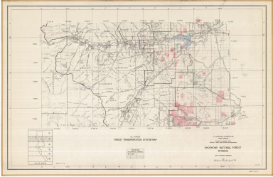
Shoshone National Forest Transportation System Map
Date
1957
Description
Shoshone National Forest Transportation System Map by US Dept of Agriculture, Forest Service, includes townships, ranges, sections, highways, roads, rivers, creeks, forest boundaries, Sheet 2 of 6
Category - Type
Map-Forest/Shoshone
Title
Medicine Bow National Forest, Forest Transportation Map
Date
1959-1961
Description
Medicine Bow National Forest, Forest Transportation Map, North Half Laramie Peak Ranger District Map, includes townships, ranges, sections, forest boundaries, roads, highways, trails, railroads, power lines, telephone lines, ranger stations, buildings, school houses, rivers, creeks, mountains, incomplete unedited copy, 1 sheet paper
Category - Type
Map-Forest/Medicine Bow/Laramie Peak
Title
Bridger National Forest Map Bridger Division East Half
Date
1964
Description
Bridger National Forest Map Bridger Division East Half by US Department of Agriculture, Forest Service includes townships, ranges, cities, towns, rivers, creeks, railroad, highways, roads, ranger stations, mines, campgrounds, picnic areas, landmarks, cabins, buildings, power lines, trails, 1 set with 1 sheet colored paper
Category - Type
Map-Forest/Bridger
Title
Bridger National Forest Map
Date
1966
Description
Bridger National Forest Map by US Department of Agriculture, Forest Service includes townships, ranges, cities, towns, rivers, creeks, railroad, highways, roads, ranger stations, mines, campgrounds, picnic areas, landmarks, cabins, buildings, power lines, trails, 2 oversized colored copies
Category - Type
Map-Forest/Bridger
Title
Bridger National Forest Bridger Division Final Inventory Map
Date
1977
Description
Bridger National Forest Bridger Division Final Inventory Map by US Dept of Agriculture, Forest Service, Edward Cliff with RARE II markings, State-Federal land transfer program, 1964 rev 1977 includes boundaries, townships, ranges, sections, rivers, creeks, reservoirs, mountains, roads, highways, trails, railroads, telephone lines, ranger stations, buildings, 1 sheet blueline paper
Category - Type
Map-Forest/Bridger
Title
Pole Mountain Travel Map, Medicine Bow National Forest, Laramie Ranger District
Date
1982
Description
Pole Mountain Travel Map, Medicine Bow National Forest, Laramie Ranger District by the US Forest Service, US Dept of Agriculture, includes township, range, section, campgrounds, picnic grounds, forest service station, rivers, creeks, hills, mountains, trails, descriptive info, recreation directory, policy and rules, vicinity maps, paper, colored
Category - Type
Map-Forest/Medicine Bow/Pole Mountain
Title
Pole Mountain Travel Map, Medicine Bow National Forest, Laramie Ranger District
Date
1983
Description
Pole Mountain Travel Map, Medicine Bow National Forest, Laramie Ranger District by the US Forest Service, US Dept of Agriculture, includes township, range, section, campgrounds, picnic grounds, forest service station, rivers, creeks, hills, mountains, trails, descriptive info, recreation directory, policy and rules, vicinity maps, paper, colored
Category - Type
Map-Forest/Medicine Bow/Pole Mountain
1-39 of 39
|