|
REFINE
Browse All : Images of Wyoming and RR Map Case 02A Drawer 03 from 1919
1-2 of 2
Title
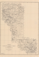
Washakie National Forest Map
Date
1919
Description
Washakie National Forest Map by US Agriculture Dept, Forest Service, HE Sealing, traced by HF Hedge, includes boundaries, townships, ranges, rivers, creeks, lakes, reservoirs, mountains, passes, ranches, 2 copies, 1 oversized (same as map 124)
Category - Type
Map-Forest/Washakie
Title
Washakie National Forest Map
Date
1919
Description
Washakie National Forest Map by US Agriculture Dept, Forest Service, HE Sealing, traced by HF Hedge, includes boundaries, townships, ranges, rivers, creeks, lakes, reservoirs, mountains, passes, ranches, 2 copies, 1 oversized (same as map 126)
Category - Type
Map-Forest/Washakie
1-2 of 2
|