|
REFINE
Browse All : Images by LC Bishop of 2 and Wyoming
1-6 of 6
Title
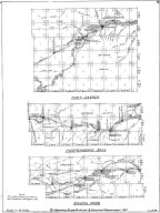
Fort Caspar, Independence Rock & South Pass Map
Date
1959
Description
02 Fort Casper, Independence Rock & South Pass Map by LC Bishop, includes townships, ranges, rivers, creeks, roads, trails, pony express stations, graves, 2 paper copies
Category - Type
Military-Fort Caspar
Title
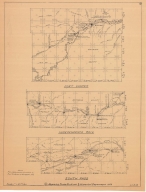
Fort Caspar, Independence Rock & South Pass Map
Date
1959
Description
02 Fort Casper, Independence Rock & South Pass Map by LC Bishop, includes townships, ranges, rivers, creeks, roads, trails, pony express stations, graves, 1 sheet vellum, 2 paper copies
Category - Type
Military-Fort Caspar
Title
Fort Laramie & Fort Fetterman Map
Date
1959
Description
01 Fort Laramie & Fort Fetterman Map, by LC Bishop, includes townships, ranges, rivers, creeks, roads, trails, pony express stations, graves
Category - Type
Military-Fort Laramie
Title
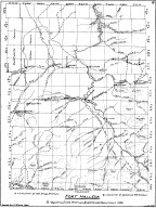
Fort Halleck Map
Date
1959-1960
Description
08 Fort Halleck Map, by LC Bishop, includes townships, ranges, rivers, creeks, roads, trails, pony express stations, graves, stage stations, abandoned railroad stations, 2 copies-1 sheet vellum, 1 sheet paper
Category - Type
Military-Fort Halleck
Title
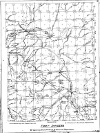
Fort Sanders Map
Date
1959-1960
Description
07 Fort Sanders Map by LC Bishop, includes townships, ranges, rivers, creeks, roads, trails, pony express stations, graves, stage stations, abandoned railroad stations
Category - Type
Military-Fort Sanders
Title
Landers Cut Off, East & West Section Map
Date
1959-1960
Description
05 Landers Cut Off, East & West Section Map by LC Bishop, includes townships, ranges, rivers, creeks, roads, trails, pony express stations, graves, 2 copies
Category - Type
Map-Trail or Road
1-6 of 6
|