Detail View: Wyoming State Archives Map Case Collection: MCDB_-1107090397
|
Identifier:
|
MCDB_-1107090397
|
|
Title:
|
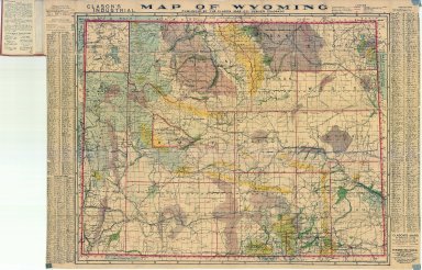
Clason's Industrial Map of Wyoming
|
|
Date:
|
1908
|
|
Description:
|
Clason's Industrial Map of WY includes townships, ranges, counties, cities, rivers, creeks, coal fields, wagon roads, irrigated lands, city & town index, mineral deposits national forests, 1 copy
|
|
Publisher or Draftsman:
|
Classon Map Co
|
|
Collection:
|
H2009-39
|
|
Rights:
|
No Copyright - United States, https://rightsstatements.org/page/NoC-US/1.0/?language=en
|
|
Coverage Location - State:
|
Wyoming
|
|
Category - Type:
|
Map-State
|
|
Type:
|
Still Image
|
|
Language:
|
English
|
|
Storage Location - Box/Drawer:
|
RR Map Case 01 Drawer 03
|
|
Storage Location - Folder:
|
3
|
|
Storage Location - Digital Copy:
|
CD Box 2/RR1188-CD83
|
|
Repository:
|
Wyoming State Archives, Department of State Parks and Cultural Resources https://wyoarchives.wyo.gov/
|
|
Get a Copy:
|
Note the Identifier and Title and email the WSA at https://wyoarchives.wyo.gov/index.php/ask-an-archivist/contact-us
|
|
Suggest an Edit:
|
Do you have additional information about this map/document? See an error? Let us know! https://tinyurl.com/WSAMapCorrection
|