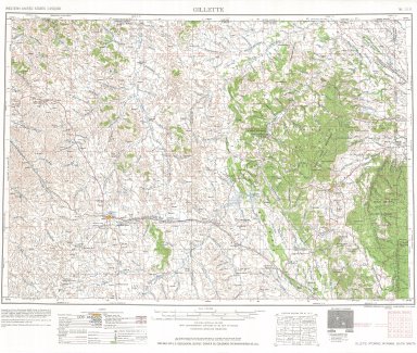
|
Title
Gillette, Wyoming, Montana, South Dakota, USGS Western US Sectionalized Township Maps
Date
1952
Description
Gillette, WY, MT, SD, USGS Western US Sectionalized Township Maps
Category - Type
Map-Topo
Title
Goshen County Map
Date
1952
Description
Goshen County Map by WY Highway Dept, Planning & Research Div, with US Dept of Commence, Bureau of Public Roads includes township, range, roads, drainage, railroads, post offices, schools, Ag exp stations, pipe lines, dwellings, towns, 1950 Co Population, 1949 aerial photo 2 sheets
Category - Type
Map-County/Goshen
Title
Oregon Trail Map
Date
1952
Description
Map Oregon Trail, 1852
Category - Type
Map-Trail or Road
Title
Platte County District Court civil case 8-254, DR 16, exhibit A, Burned Over Acreage on LD Ranch, Bordeaux, WY
Date
1952
Description
Platte County District Court civil case 8-254, DR 16, exhibit A, Burned Over Acreage on LD Ranch, Bordeaux, WY, by JA Cole, includes Township 22 & Township 23, Range 66 & Range 67, key map with railroad tracks, detail maps of Tract 1, 2, & 3 showing railroad track location & meadow/pasture acreage, 1 set with 1 sheet blueline paper
Category - Type
Court Exhibits
Title
Platte County District Court civil case 8-318, DR 17, exhibit A, Platte County Map
Date
1952
Description
Platte County District Court civil case 8-318, DR 17, exhibit A, Platte County Map by JA Cole, incl township, ranges, sections, highways, roads, trails, land owner names, railroads, river, creeks, hills, laterals, tunnels, reservoirs, towns, power lines, school district boundaries, 1 set with 1 sheet color-coded paper
Category - Type
Court Exhibits
Title
Platte County Map
Date
1952
Description
Platte County Map by WY Highway Dept, Planning & Research Div, with US Dept of Commence, Bureau of Public Roads includes township, range, roads, drainage, railroads, post offices, schools, Ag exp station, pipe lines, dwellings, towns, 1950 Co Population, 1949 aerial photo 2 sets 1 incomplete
Category - Type
Map-County/Platte
Title
Shoshone National Forest Map
Date
1952
Description
Shoshone National Forest Map by US Dept of Agriculture, Forest Service, includes townships, ranges, rivers, creeks, mountains, roads, highways, telephone lines, telegraph lines, power line, ditches, ranger stations, buildings, schools, mines, cemetery, forest boundaries, 1 colored copy
Category - Type
Map-Forest/Shoshone
Title
Wyoming Highway Map
Date
1952
Description
Highway Map by WY State Highway Dept 3 copies
Category - Type
Map-State
Title
Wyoming Highway Map
Date
1952
Description
Highway Map by WY State Highway Dept 3 copies
Category - Type
Map-State
Title
Laramie County School Dist 9, Egbert Gymnasium Addition plans, Egbert, WY
Date
1952
Description
Laramie County School Dist 9, Egbert Gymnasium Addition plans, Egbert, WY, by Robert W. Postin, 1 set with 8 sheets (7 sheets-green vellum, 1 sheet-paper)
Category - Type
Plan/Specification
Title
Weston County School District 7/Upton High School, walks, drainage, grading Upton, WY
Date
1952
Description
Weston County School District 7/Upton High School, walks, drainage, grading Upton, WY, by DE Matter & Robert W. Postin, 1 set with 2 sheets (1 sheet-blueline paper, 1 undersized sheet-paper)
Category - Type
Plan/Specification
Title
Wyoming Game & Fish Dept Torrington plan
Date
1952
Description
WY Game & Fish Dept Torrington
Category - Type
Plan/Specification
Title
Wyoming Hot Springs State Park Sewage Treatment Facilities
Date
1952
Description
Wyoming Hot Springs State Park Sewage Treatment Facilities by Robert L Streeter, job 5210, 1 complete set with 5 sheets paper, 1 incomplete set with 4 sheets paper
Category - Type
Plan/Specification
Title
Wyoming State Boys School/Industrial Institute Cell Block Alteration Plan
Date
1952
Description
WY State Boys School/Industrial Institute Cell Block Alteration Plan by Tressler-McCall & Assoc, 1 set with 2 sheets blueline paper
Category - Type
Plan/Specification
Title
Wyoming State Boys School/Industrial Institute Swimming Pool & Gymnasium Proposed Plan
Date
1952
Description
WY State Boys School/Industrial Institute Swimming Pool & Gymnasium Proposed Plan by Tressler-McCall & Assoc, 1 set with 3 sheets blueline paper
Category - Type
Plan/Specification
Title
Wyoming State Childrens Home Wading Pool
Date
1952
Description
WY State Childrens Home Wading Pool by Robert L Streeter, job 5214, 1 set with 1 sheet color-coded paper
Category - Type
Plan/Specification
Title
Wyoming State Penitentiary Cell Block Addition Plan (Chapel Remodel Plans Attached)
Date
1952
Description
WY State Penitentiary Cell Block Addition Plan (Chapel Remodel Plans Attached), job 5220, 1 incomplete set with 3 sheets blueline paper
Category - Type
Plan/Specification
Title
Wyoming State Penitentiary Chapel Remodel Plans
Date
1952
Description
WY State Penitentiary Chapel Remodel Plans (Attached to Cell Block Addition Plan), job 5220, 1 incomplete set with 3 sheets blueline paper
Category - Type
Plan/Specification
Title
Wyoming State Pioneer Home (Home & Hospital for the Aged) Addition Units F & G
Date
1952
Description
WY State Pioneer Home (Home & Hospital for the Aged) Addition Units F & G, by Goodrich & Wilking, 3 sets, 3 sheets blueline paper
Category - Type
Plan/Specification
Title
Wheatland Hilltop Addition plat
Date
1952
Description
Wheatland Hilltop Addition plat
Category - Type
Map-City/Wheatland
Title
South Cheyenne South Hill Park, Highland Park, Allison Tracts, Prosser Tracts, Broadmoor plat
Date
1952
Description
South Cheyenne South Hill Park, Highland Park, Allison Tracts, Prosser Tracts, Broadmoor plat
Category - Type
Map-City/Cheyenne
Title
South Cheyenne, Street Name map
Date
1952
Description
South Cheyenne, Street Name, 3 copies
Category - Type
Map-City/Cheyenne
Title
South Cheyenne, Street Name map
Date
1952
Description
South Cheyenne, Street Name, 3 copies
Category - Type
Map-City/Cheyenne
Title
South Cheyenne, Street Name map
Date
1952
Description
South Cheyenne, Street Name, 3 copies
Category - Type
Map-City/Cheyenne
Title
Cheyenne Block 191, Lots 3 and 4. Proposed subdivision. Duff and 23rd
Date
1952
Description
Cheyenne Block 191, Lots 3 and 4. Proposed subdivision. Duff and 23rd.
Category - Type
Map-City/Cheyenne
Title
Cheyenne Block 294, Lots 3 and 4 plat
Date
1952
Description
Cheyenne Block 294, Lots 3 and 4 plat. 20th and Capitol.
Category - Type
Map-City/Cheyenne
Title
Cheyenne Block 325, North 80' Lot 1, SW corner 19th and House
Date
1952
Description
Cheyenne Block 325, North 80' Lot 1, SW corner 19th and House
Category - Type
Map-City/Cheyenne
Title
Cheyenne Block 327, Lot 8 plat
Date
1952
Description
Cheyenne Block 327, Lot 8 plat. 18th Street and Central.
Category - Type
Map-City/Cheyenne
Title
Cheyenne Block 327, Lot 8 plat
Date
1952
Description
Cheyenne Block 327, Lot 8 plat. 18th Street and Central.
Category - Type
Map-City/Cheyenne
Title
Cheyenne Block 327, Lot 8 plat
Date
1952
Description
Cheyenne Block 327, Lot 8 plat. 18th Street and Central.
Category - Type
Map-City/Cheyenne
Title
Cheyenne Block 385, South 55' Lot 5 plat
Date
1952
Description
Cheyenne Block 385, South 55' Lot 5 plat, NE corner 16th and Evans.
Category - Type
Map-City/Cheyenne
Title
Cheyenne Block 413, Lots 9 through 11. 16th and Bent.
Date
1952
Description
Cheyenne Block 413, Lots 9 through 11. 16th and Bent.
Category - Type
Map-City/Cheyenne
Title
Cheyenne Block 43, Lots 5 and 6 plat, Randall, Thomes and 27th Street
Date
1952
Description
Cheyenne Block 43, Lots 5 and 6 plat, Randall, Thomes and 27th Street
Category - Type
Map-City/Cheyenne
Title
Cheyenne Block 435, Lots 7 and 8. NW corner Logan and 14th Street
Date
1952
Description
Cheyenne Block 435, Lots 7 and 8. NW corner Logan and 14th.
Category - Type
Map-City/Cheyenne
Title
Cheyenne Plat Block 484
Date
1952
Description
Cheyenne plat Block 484
Category - Type
Map-City/Cheyenne
Title
Country Homes plat
Date
1952
Description
Country Homes plat
Category - Type
Map-City/Cheyenne
Title
Darnell Homesites plat, Section 27 Township 14 Range 66
Date
1952
Description
Darnell Homesites plat, Section 27 Township 14 Range 66
Category - Type
Map-City/Cheyenne
Title
Evans, Subdivision of Tracts 209-212, Sunnyside Addition 6th Filing plat
Date
1952
Description
Evans, Subdivision of Tracts 209-212, Sunnyside Addition 6th Filing plat
Category - Type
Map-City/Cheyenne
Title
Fairview Addition plat
Date
1952
Description
Fairview Addition plat
Category - Type
Map-City/Cheyenne
Title
Federer Tracts, Nw/4 13-13 Range 67
Date
1952
Description
Federer Tracts, Nw/4 13-13 Range 67
Category - Type
Map-City/Cheyenne
Title
Foster Tracts 2nd Filing plat
Date
1952
Description
Foster Tracts 2nd Filing plat
Category - Type
Map-City/Cheyenne
Title
Hill Heights Addition plat
Date
1952
Description
Hill Heights Addition plat
Category - Type
Map-City/Cheyenne
Title
Hyndman Homesites plat
Date
1952
Description
Hyndman Homesites plat, N/2 Section 31 Township 13 Range 66
Category - Type
Map-City/Cheyenne
Title
Lake Tracts, W/2 SE/4 NE/4, NE/4 Section 8 Township 13 Range 66 plat
Date
1952
Description
Lake Tracts, W/2 SE/4 NE/4, NE/4 Section 8 Township 13 Range 66 plat
Category - Type
Map-City/Cheyenne
Title
Lake Tracts, W/2 SE/4 NE/4, NE/4 Section 8 Township 13 Range 66 plat
Date
1952
Description
Lake Tracts, W/2 SE/4 NE/4, NE/4 Section 8 Township 13 Range 66 plat
Category - Type
Map-City/Cheyenne
Title
McCann Homesites 34 Township Range 66
Date
1952
Description
McCann Homesites 34 Township Range 66
Category - Type
Map-City/Cheyenne
|