|
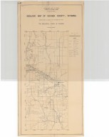
Title
Fort Laramie to Cheyenne Pass Route
Date
1858
Description
Route from Fort Laramie to Cheyenne Pass by BVT Major Williams with orders to establish a post, includes sketch of Camp Walbach and Pedistal Rock
Category - Type
Military-Camp Walbach
Title
Asher & Adams' Map of Wyoming (mislabeled 1874)
Date
1872 Circa
Description
Asher & Adams' Map of WY (mislabeled 1874) includes townships, ranges, cities, towns, railroads, rivers, creeks
Category - Type
Map-State
Title
Asher & Adams' Map of Wyoming (mislabeled 1874)
Date
1872 Circa
Description
Asher & Adams' Map of WY (mislabeled 1874) includes townships, ranges, cities, towns, railroads, rivers, creeks
Category - Type
Map-State
Title
Wyoming Map
Date
1875 Circa
Description
WY Map drawn by WM Masi for JH Triggs' History of Cheyenne & Northern WY includes rivers, creeks, railroads, forts, wagon roads and trails, mountains
Category - Type
Map-State
Title
Cheyenne Birds Eye View Map
Date
1882
Description
Cheyenne Birds Eye View Map by Beck & Pauli, JJ Stoner includes streets, avenues, buildings, railroads, 4 building images, index to some buildings 5 copies
Category - Type
Map-Birds Eye View/Cheyenne
Title
Cheyenne Birds Eye View Map
Date
1882
Description
Cheyenne Birds Eye View Map by Beck & Pauli, JJ Stoner includes streets, avenues, buildings, railroads, 4 building images, index to some buildings 5 copies
Category - Type
Map-Birds Eye View/Cheyenne
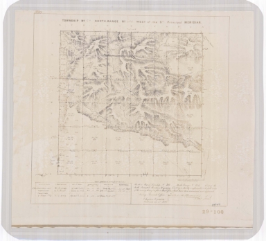
Title
South Pass City Field Notes
Date
1882
Description
South Pass City Field Notes published by JAJ Leary, John C Probst-Deputy Surveyor, includes Township 29, Range 100, 4 sheets paper (undersized)
Category - Type
Map-Site
Title
Wyoming Map
Date
1905
Description
WY Map by US Dept of Interior includes US surveyor general's office, US land offices, townships, ranges, Indian reservations, military reservations, forest reserves, national parks & monuments, bird reserves, land district boundaries
Category - Type
Map-State
Title
Cheyenne Experiment Farm Map
Date
1907
Description
Cheyenne Experiment Farm Map, by US Dept of Agriculture, Office of Experiment Stations, includes, types of crops, locations of wells, evaporation tanks, reservoir, roads, railroad, 1 set with 1 sheet blueprint
Category - Type
Map-Site
Title
Wyoming Map
Date
1907
Description
WY Map by US Dept of Interior includes US surveyor general's office, US land offices, townships, ranges, Indian reservations, military reservations, forest reserves, national parks & monuments, bird reserves, land district boundaries 3 copies
Category - Type
Map-State
Title
Wyoming Map
Date
1907
Description
WY Map by US Dept of Interior includes US surveyor general's office, US land offices, townships, ranges, Indian reservations, military reservations, forest reserves, national parks & monuments, bird reserves, land district boundaries 3 copies
Category - Type
Map-State
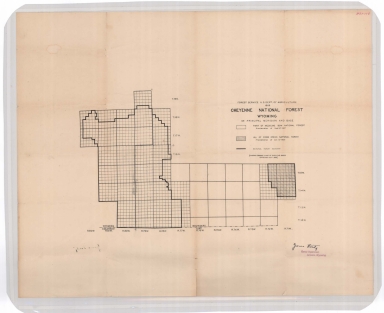
Title
Cheyenne National Forest map
Date
1908
Description
Cheyenne National Forest by US Dept of Agriculture, US Forest Service, includes Crow Creek National Forest boundaries, townships, ranges, sections
Category - Type
Map-Forest/Cheyenne
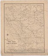
Title
Crow Creek Forest Reserve Map
Date
1908
Description
Crow Creek Forest Reserve Map Albany County, Maneuver Ground by 3rd Battalion of Engineers, PS Bond, EJ Atkinson, includes mountains, cabin, cities, towns, ranches, passes, roads, dams, building locations, contours, linen, colored
Category - Type
Map-Forest/Crow Creek
Title
Big Horn County Map
Date
1908 Circa
Description
Big Horn County Map, WY includes named national forest lands, major water courses, cities, shaded relief, township lines, Guide Meridian 7 Standard Parallel lines, proclamation dates for federal reservations, northern part of Wind River Indian Reservation cities, railroads, battle ground locations by name.
Category - Type
Map-County/Big Horn
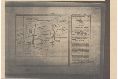
Title
South Pass Mining District Plat of LL Giessler & JJ Morrin Claim, known as the Lucky Boy Lode
Date
1910
Description
South Pass Mining District Plat of LL Giessler & JJ Morrin Claim, known as the Lucky Boy Lode includes location & names of lodes, rivers, city buildings, 1 sheet paper
Category - Type
Map-Site
Title
Laramie County Land Ownership Map
Date
1916
Description
Laramie County Land Ownership Map by EW Glafcke includes township, range, towns, mining district, school district, landowner names, school location, post offices, railroad, highway, roads, rivers, creeks, trails Blueline
Category - Type
Map-County/Laramie
Title
Wyoming Road Map
Date
1930
Description
Road Map of WY by Standard Oil Co., includes cities, towns, sites, index, counties, highways, roads, rivers, creeks, portions of South Dakota, Nebraska, Colorado, Utah, Idaho, road maps of US and Yellowstone National Park on back, 1 paper copy, colored
Category - Type
Map-State
Title
Wyoming Highway Map and Guide of Wyoming,
Date
1930 Circa
Description
Highway Map and Guide of WY, by Mid-West Map Co, includes cities & towns, airport or landing strips, rivers, mountains, National Park, drawing of State and US Highway Marker signs, on back---Authorized Guide & Maps Stations of WY (descriptions of sponsored lodging & service stations/gas stations, restaurants, some with prices listed, city and town index, ad for Hot Springs State Park, 1 set with 1 sheet blueline paper
Category - Type
Map-State
Title
Wyoming Transportation Map
Date
1930 Circa
Description
WY Transportation Map includes railroad, bus, airplane routes, US & state highway routes vellum
Category - Type
Map-State
Title
Wyoming Transportation Map
Date
1930 Circa
Description
WY Transportation Map includes railroad, bus, airplane routes, US & state highway routes vellum
Category - Type
Map-State
Title
Wyoming Map
Date
1931
Description
WY Map by the US Dept of Interior includes public survey offices, land offices, townships, ranges, grazing districts, national forests, Indian reservations, military reservations, bureau of reclamation projects, national parks, monuments
Category - Type
Map-State
Title
Official Road Map of Wyoming
Date
1932
Description
Official Road Map by Conoco, includes cities, towns, index, counties, rivers, creeks, mountains, map of Yellowstone National Park and Pictorial Map of US on back, 1 paper copy, colored
Category - Type
Map-State
Title
Wyoming State Highway System map
Date
1933
Description
WY State Highway System map includes cities, towns, highways, possible survey indicators, 1 sheet paper
Category - Type
Map-State
Title
Wyoming Highway Map
Date
1934
Description
Highway Map by Conoco, includes cities, towns, index, counties, rivers, creeks, mountains, reservoirs, maps of Yellowstone National Park, Teton National Park, Rocky Mountain National Park, Cheyenne, Ogden and Casper 1 paper copy, colored
Category - Type
Map-State
Title
Albany County Geologic Map
Date
1935
Description
Albany County Geologic Map by Geological Survey of WY, David Love, from WY State Planning Board/WY State Planning & Water Conservation Board records, includes townships & ranges, cities & towns, rivers & creeks, highway, railroad, formations, 1 set with 1 sheet blueline paper
Category - Type
Map-County/Albany
Title
Traffic Survey Map of Wyoming
Date
1935
Description
Traffic Survey Map includes counties, cities, towns, US highways, rate index vellum
Category - Type
Map-State
Title
Wyoming Highway Map
Date
1935
Description
Highway Map by WY State Highway Dept 3 copies
Category - Type
Map-State
Title
Wyoming Highway Map
Date
1935
Description
Highway Map by WY State Highway Dept 3 copies
Category - Type
Map-State
Title
Goshen County Geologic Map
Date
1936
Description
Goshen County Geologic Map by Geological Survey of WY, Arthur M Morgan, from WY State Planning Board/WY State Planning & Water Conservation Board records, includes townships & ranges, cities & towns, rivers & creeks, highway, railroad, formations, 1 set with 1 sheet blueline paper
Category - Type
Map-County/Goshen
Title
Wyoming Highway Map
Date
1936
Description
Highway Map by WY State Highway Dept 3 copies
Category - Type
Map-State
Title
Wyoming Highway Map
Date
1936
Description
Highway Map by WY State Highway Dept 3 copies
Category - Type
Map-State
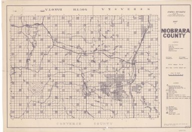
Title
Niobrara County Map
Date
1936-1945
Description
Niobrara County Map by State Mineral Supervisor Pierre LaFleiche, Drafted by HG Lowman includes oil & gas fields, township, range, state land, primary & secondary roads WPA Project 6008 1936, 1945
Category - Type
Map-County/Niobrara
Title
Laramie County Map
Date
1936-1951
Description
Laramie County Map by State Mineral Supervisor Pierre LaFleiche, drafted by HG Lowman includes oil & gas fields, drainage, township, range, state land, primary & secondary roads WPA Project 6999 ca1936, 1945, 1951, 1 set blueline paper, 2 sets vellum, 1 set mylar, 1 set linen
Category - Type
Map-County/Laramie
Title
Niobrara County Map
Date
1936-1951
Description
Niobrara County Map by State Mineral Supervisor Pierre LaFleiche, Drafted by HG Lowman includes oil & gas fields, drainage, township, range, state land, primary & secondary roads WPA Project 109, 6/1936, rev 1945, rev 1951, 1 set blueline paper, 2 sets vellum
Category - Type
Map-County/Niobrara
Title
Platte County Geologic Map
Date
1937
Description
Platte County Geologic Map by Geological Survey of WY, from WY State Planning Board/WY State Planning & Water Conservation Board records, includes townships & ranges, cities & towns, rivers & creeks, highway, railroad, formations, 1 set with 1 sheet blueline paper
Category - Type
Map-County/Platte
Title
Wyoming Highway Map
Date
1937
Description
Highway Map by WY State Highway Dept 3 copies
Category - Type
Map-State
Title
Wyoming Highway Map
Date
1937
Description
Highway Map by WY State Highway Dept 3 copies
Category - Type
Map-State
Title
Wyoming Map
Date
1937
Description
WY Map by US Dept of Interior, US Geological Survey, cartographer AF Hassan includes townships, ranges, counties, rivers, creeks, cities, towns, railroads, national forests, reservoirs, color coding of plant types (penciled on map), 1 map, linen backed
Category - Type
Map-State
Title
Wyoming Map
Date
1937
Description
WY Map Showing the State Highway System by the WY Highway Dept, includes counties, cities, towns, highways, forests, Indian reservation, 1 sheet blueline paper
Category - Type
Map-State
Title
Big Horn County Map
Date
1937-1945
Description
Big Horn County Map by State Mineral Supervisor Pierre LaFleiche, drafted by HG Lowman includes oil & gas fields, drainage, township, range, state land, primary & secondary roads WPA Project1/1937, 1945, 2 sets
Category - Type
Map-County/Big Horn
Title
Big Horn County Map
Date
1937-1951
Description
Big Horn County Map by State Mineral Supervisor Pierre LaFleiche, drafted by HG Lowman includes oil & gas fields, drainage, township, range, state land, primary & secondary roads WPA Project 12/1937, rev 1945, rev 1951, 1 set blueline paper, 2 sets vellum
Category - Type
Map-County/Big Horn
|