|
Title
Fort Leavenworth to the Great Salt Lake Route
Date
1850
Description
Map of Route from Fort Leavenworth to the Great Salt Lake. State border, the North Platte River, the South Pllatte River and the Great Salt Lake are highlighted
Category - Type
Map-Trail or Road
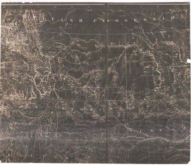
Title
Fort Kearney, South Pass, and Honey Lake Wagon Road Preliminary Map (Lander's Cut-off)
Date
1857-1858
Description
Fort Kearney, South Pass, and Honey Lake Wagon Road Preliminary Map (Lander's Cut-off) 1857-by FW Lander and WH Wagner, includes roads, rivers, creeks, passes, gaps, railroads, cities, towns, mountains, photostatic copy
Category - Type
Map-Trail or Road
Title
Johnson's Nebraska, Dakota, Idaho, Montana (includes Wyoming) map
Date
1868 Circa
Description
Johnson's Nebraska, Dakota, Idaho, Montana (includes WY) includes creeks, rivers, roads pages 62-63 1 original, 1 transparency, 1 blue line
Category - Type
Map-State
Title
Johnson's Nebraska, Dakota, Idaho, Montana (includes Wyoming) map
Date
1868 Circa
Description
Johnson's Nebraska, Dakota, Idaho, Montana (includes WY) includes creeks, rivers, roads pages 62-63 2 copies
Category - Type
Map-State
Title
Wyoming Map
Date
1868 Circa
Description
WY Map, includes portions of Nebraska, Dakota, Montana, Idaho, Colorado, Utah, cities, towns, forts, railroads, rivers, creeks, mountains, Indians, 1 partial map, negative, paper
Category - Type
Map-State
Title
Wyoming Map
Date
1868 Circa
Description
WY Map, includes portions of Nebraska, Dakota, Montana, Idaho, Colorado, Utah, cities, towns, forts, railroads, rivers, creeks, mountains, Indians, 1 partial map, negative, paper
Category - Type
Map-State
Title
Wyoming Map
Date
1869
Description
WY Map (accompanied the annual report of the commissioner of the general land office) 2 copies 1 partial-negative, 1 copy
Category - Type
Map-State
Title
Colorado, Wyoming, Dakota, Montana County map
Date
1869 Circa
Description
County map of Colorado, WY, Dakota, Montana includes rivers, creeks, forts, pony express route pages 88, 89
Category - Type
Map-State
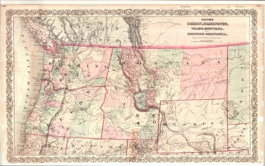
Title
Colton's Oregon, Washington, Idaho, Montana & British Columbia (includes Wyoming) map
Date
1869 Circa
Description
Colton's Oregon, Washington, Idaho, Montana & British Columbia (includes WY) includes creeks, rivers, railroads, cities, towns, trails, forts pages 82, 83
Category - Type
Map-State
Title
Kansas, Nebraska, Colorado & Dacotah (includes Wyoming) map
Date
1869 Circa
Description
Map of Kansas, Nebraska, Colorado & Dacotah (includes WY) includes rivers, creeks, cities, towns, forts page 52
Category - Type
Map-State
Title
Laramie River & Tributaries Tabulations of Adjudicated Water
Date
1869-1911
Description
Laramie River & Tributaries Tabulations of Adjudicated Water Rights, WY State Engineer, includes priority number, ditch name, name of appropriator, Post Office address, use, amount appropriated, number of acres irrigated & description of lands irrigated, 2 bundles with 36 sheets paper
Category - Type
Map-Water
Title
Cheyenne Birds Eye View Map
Date
1870
Description
Cheyenne Birds Eye View Map includes buildings railroad, creek, fort (1 reprint, compliments of North Cheyenne Development Co) 3 copies
Category - Type
Map-Birds Eye View/Cheyenne
Title
Cheyenne Birds Eye View Map
Date
1870
Description
Cheyenne Birds Eye View Map includes buildings railroad, creek, fort (1 reprint, compliments of North Cheyenne Development Co) 3 copies
Category - Type
Map-Birds Eye View/Cheyenne
Title
Cheyenne Plat
Date
1870
Description
Cheyenne Plat by August Koch includes lots, blocks, creeks, dedication 1 Xerox copy
Category - Type
Map-City/Cheyenne
Title
Cheyenne Plat
Date
1870
Description
Cheyenne Plat by August Koch includes lots, blocks, creeks, dedication 1 Xerox copy
Category - Type
Map-City/Cheyenne
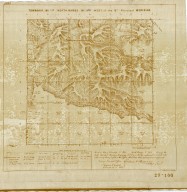
Title
Survey Map Township 13, Range 65, Sections 1 - 36
Date
1870
Description
Survey Map by Silas Reed, surveyed by Edwin James, Henry G. Hays, John B. Thomas, US Surveyor General's Office, Township 13, Range 65, Sections 1 - 36, includes topo info, rivers, Wagon Road to Cheyenne, total number of acres, date of contracts, amount of surveys, No. 0054, 54, 1 set with 1 sheet negative paper
Category - Type
Map-Survey
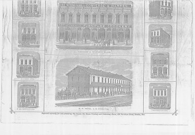
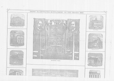
Title
Cheyenne Birds Eye View, "Cheyenne, the Gateway to the Land of Gold"
Date
1876
Description
Cheyenne Birds Eye View, "Cheyenne, the Gateway to the Land of Gold", illustrated from the Omaha Daily Bee includes drawings of buildings, & map of Black Hills Gold region 2 pages (Xeroxes, pages split in half--total of 4 )
Category - Type
Map-Birds Eye View/Cheyenne
Title
Cheyenne Birds Eye View, "Cheyenne, the Gateway to the Land of Gold"
Date
1876
Description
Cheyenne Birds Eye View, "Cheyenne, the Gateway to the Land of Gold", illustrated from the Omaha Daily Bee includes drawings of buildings, & map of Black Hills Gold region 2 pages (Xeroxes, pages split in half--total of 4 )
Category - Type
Map-Birds Eye View/Cheyenne
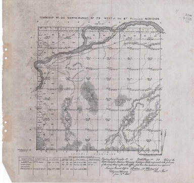
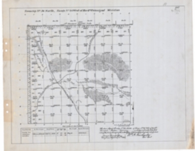
Title
Survey Map Township 33, Range 79, Sections 1 - 36
Date
1883
Description
Survey Map by Edw. C David, surveyed by Wm O. Owen, Downey & Grant, US Surveyor General's Office, printed-A Gast & Co, Township 33, Range 79, Sections 1 - 36, includes topo info, North Platte River, roads, creeks, total number of acres, dates of contracts , amount of surveys, magnetic declination, No. 2026, 1 set with 1 sheet negative paper
Category - Type
Map-Survey
Title
Survey Map Township 34, Range 79, Sections 1 - 36
Date
1883
Description
Survey Map by Edw. C David, surveyed by Wm O. Owen, US Surveyor General's Office, printed-A Gast & Co, Township 34, Range 79, Sections 1 - 36, includes North Platte River, creeks, roads, dry lakes, total number of acres, amount of surveys, magnetic declination, No. 2027, 76 1 set with 1 sheet negative paper
Category - Type
Map-Survey
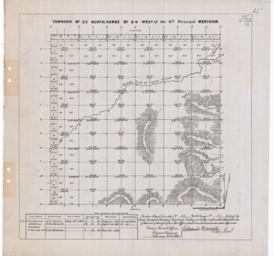
Title
Survey Map Township 35, Range 84, Sections 1 - 36
Date
1883
Description
Survey Map by Edw. C. David, surveyed by FO Sawin, JB Menardi, US Surveyor General's Office, printed-A Gast & Co, Township 35, Range 84, Sections 1 - 36, includes topo info, creeks, bottom land, total number of acres, date of contracts, amount of surveys, No. 1254, 1 set with 1 sheet negative paper
Category - Type
Map-Survey
Title
Survey Map Township 29, Range 100, Sections 1 - 36
Date
1884
Description
Survey Map by Edw. C David, surveyed by Wm B. Yerby, JL Propst, US Surveyor General's Office, printed-A Gast & Co, Township 29, Range 100, Sections 1 - 36, includes topo info, roads, South Pass City, Atlantic City, meadow, telegraph lines, mine shaft, Atlantic Gulch, creeks, total number of acres, date of contracts, amount of surveys, magnetic declination, 1 set with 1 sheet negative paper
Category - Type
Map-Survey
Title
Albany County Map, plat of County road from Laramie to Fort Fetterman
Date
1890
Description
Albany County Map, plat of County road from Laramie to Fort Fetterman, includes township, range, County roads, stage routes, rivers, creeks, lakes, towns, railroads Xerox copy
Category - Type
Map-Trail or Road
Title
Survey Map Township 42, Range 108, Sections 1 - 36
Date
1892
Description
Survey Map by Wm A. Richards, surveyed by Carpenter & Warner, US Surveyor General's Office, printed-A Gast & Co, Township 42, Range 108, Sections 1 - 36, includes topo info, roads, Clark, creeks, total number of acres, dates of contracts, amount of surveys, magnetic declination, No. 4392, 2 sets with 1 sheet negative paper
Category - Type
Map-Survey
Title
Survey Map Township 43, Range 108, Sections 1 - 36
Date
1892
Description
Survey Map by Wm A. Richards, surveyed by Carpenter & Warner, US Surveyor General's Office, printed-A Gast & Co, Township 43, Range 108, Sections 1 - 36, includes topo info, Bonneville National Forest, dry lakes, pond, creeks, total number of acres, dates of contracts, amount of surveys, magnetic declination, No. 4393, 1 set with 1 sheet negative paper
Category - Type
Map-Survey
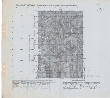
Title
Survey Map Township 43, Range 94, Sections 1 - 36
Date
1892
Description
Survey Map by Wm A. Richards, surveyed-Carpenter & Warner, US Surveyor General's Office, printed-A Gast & Co, Township 43, Range 94, Sections 1 - 36, includes East Boundary of Shoshone Indian Reservation, Big Horn River, topo info, roads, creeks, total number of acres, dates of contracts, amount of surveys, magnetic declination, No 1969, 1 set with 1 sheet negative paper
Category - Type
Map-Survey
Title
Survey Map Township 44, Range 94, Sections 1 - 36
Date
1892
Description
Survey Map by Wm A. Richards, surveyed by Carpenter & Warner, US Surveyor General's Office, printed-A Gast & Co, Township 44, Range 94, Sections 1 - 36, includes , Big Horn River, stock corral, roads, topo info, creeks, total number of acres, dates of contracts, amount of surveys, magnetic declination, No 4416, 1 set with 1 sheet negative paper
Category - Type
Map-Survey
Title
Survey Map Township 33, Range 90, Sections 1 - 36
Date
1893
Description
Survey Map by Wm A. Richards, surveyed by Coleman & Gilcrest, US Surveyor General's Office, printed-A Gast & Co, Township 33, Range 90, Sections 1 - 36, includes topo info, Ervay to Muskrat Road, roads, Clay City Ruins, Sarcophegas Buttes, Willow Creek, Salt Sage Flat, Oil Prospect Holes, Sand Rock Point, creeks, total number of acres, dates of contracts, amount of surveys, magnetic declination, 1 set with 1 sheet negative paper
Category - Type
Map-Survey
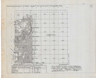
Title
Survey Map Township 42, Range 94, Sections 5 - 8, 17 - 20
Date
1898
Description
Survey Map by Alpheus P. Hanson, surveyed-EF Stahle, Frank S. Wood, US Surveyor General's Office, printed-The Norris Peters Co., Township 42, Range 94, Sections 5 - 8, 17 - 20, includes Shoshone Indian Reservation North Boundary, Lander & Thermopolis Road roads, Old East Boundary Shoshoni Indian Reservation, topo info, Big Horn River, creeks, total number of acres, date of contracts, amount of surveys, No. 4684, 2 sets with 1 sheet negative paper
Category - Type
Map-Survey
Title
United States Geological Survey Western United States Forest reserves
Date
1899
Description
US Geological Survey map location of the forest reserves & national parks in the western US Forest reserves are named & numbered. Map includes US west of 97 degree longitude, major river courses, State boundaries, topographic relief in mountains, Canadian and Mexican borders, Pacific Ocean with place names along seashore, city locations, lakes
Category - Type
Map-Forest
Title
Survey Map Township 43, Range 94, Sections 5, 7 -8, 17 - 20, 29 - 32
Date
1900
Description
Survey Map by Alpheus P. Hanson, surveyed-Edward F. Stahle, Frank S. Wood, US Surveyor General's Office, printed-The Norris Peters Co., Township 43, Range 94, Sections 5, 7 -8, 17 - 20, 29 - 32, includes Old East Shoshone Indian Reservation Boundary, Road to Casper, roads, ditches, topo info, Big Horn River, principal spirng, creeks, total number of acres, date of contracts, amount of surveys, No. 1970, 2 sets with 1 sheet negative paper
Category - Type
Map-Survey
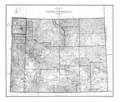
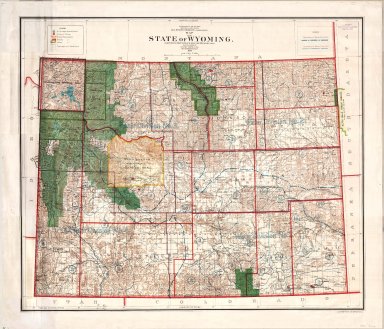
Title
Wyoming Map
Date
1900
Description
WY Map by US Dept of Interior, General Land Office includes surveyor general's office, US Land offices, townships, ranges, Indian reservations, military reservations, forest reserves 3 copies ( 1 reverse positive)-not colored map?
Category - Type
Map-State
Title
Wyoming Map
Date
1900
Description
WY Map by US Dept of Interior, General Land Office includes surveyor general's office, US Land offices, townships, ranges, Water Divisions & Districts, Indian reservations, military reservations, forest reserves, 1 linen backed paper copy
Category - Type
Map-State
Title
Wyoming Map
Date
1900
Description
WY Map by US Dept of Interior, General Land Office includes surveyor general's office, US Land offices, townships, ranges, Indian reservations, military reservations, forest reserves, 2 copies
Category - Type
Map-State
Title
Post Route Map of the States of Montana, Idaho & Wyoming
Date
1903
Description
Post Route Map of the States of Montana, Idaho & WY, by Postmaster General Henry C. Payne, under direction of A. VonHaake, includes East Oregon & Washington, Northeast Utah, West North Dakota, South Dakota & Nebraska, extreme North Colorado, index to counties, designations for: railroads, frequency of mail service, post offices, cities, towns, counties, 1 set colored paper with 2 pages
Category - Type
Map-State
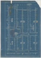
Title
Casper Zoning Map
Date
1904
Description
Casper Map, includes lots & blocks, streets & avenues, North Platte River, railroad tracks, Depot Grounds-Wyoming Central Railway, 1 set with 1 sheet blueprint
Category - Type
Map-City/Casper
Title
Resurvey Map Township 55, Range 100, Section 1 - 36
Date
1906
Description
Resurvey Map by Alpheus P. Hanson, US Surveyor General, surveyed by Brunt & Bandy, Arthur H Brunt, US Dept of Interior, includes Township 55, Range 100, Sec 1 - 36, lots, topo info, Shoshone River, Garland to Cody Road, Cody to Red Lodge Road, road, telegraph line, B&M Railroad Track, B&M Pump House, School Sections, creeks, Private Land Claims Table with lot no., total acres & acres in township, No. 3422, 2 sets with 1 sheet negative paper
Category - Type
Map-Survey
Title
Resurvey Map Township 56, Range 100, Section 1 - 36
Date
1906
Description
Resurvey Map by Alpheus P. Hanson, US Surveyor General, surveyed by Brunt & Bandy, CA Honey, Arthur H Brunt, US Dept of Interior, includes Township 56, Range 100, Sec 1 - 36, lots, topo info, Shoshone River, Cody to Red Lodge Road, roads, creeks, School Sections, Private Land Claims Table with lot no., total acres & acres in township, No. 3433, 1 set with 1 sheet negative paper
Category - Type
Map-Survey
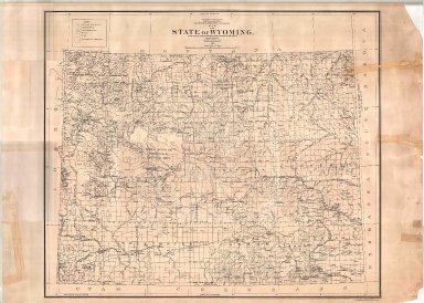
Title
Wyoming Map
Date
1906
Description
WY Map by Kenyon Printing & Manufacturing Co. copyrighted in 1906 by George F Cram index to towns, counties and railroads on back, Stockgrowers National Bank stamped on front Xerox copy. Map includes townships & ranges, counties, cities & towns, railroads, mountains & hills, rivers and lakes, 1 set with 1 sheet xerox paper
Category - Type
Map-State
|