|
REFINE
Browse All : Images of 1 and Natrona County
1-27 of 27
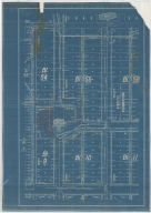
Title
Casper Zoning Map
Date
1904
Description
Casper Map, includes lots & blocks, streets & avenues, North Platte River, railroad tracks, Depot Grounds-Wyoming Central Railway, 1 set with 1 sheet blueprint
Category - Type
Map-City/Casper
Title
Natrona County Map
Date
1921
Description
Natrona County Map by Wheeler & Worthington, HF Hedge, compiled from government & state bulletins includes township, range, railroads, post offices, roads, ranches, schools, trails, pipelines, mines, telephone lines, shearing pens, towns 2 sets with 1 sheet blueline linen backed paper
Category - Type
Map-County/Natrona
Title
Casper Plat
Date
1922
Description
Casper Plat by Casper City Engineering Dept includes lots, blocks, streets, railroad, river, refineries, portion of map color coded-with no explanation 1 vellum
Category - Type
Map-City/Casper
Title
Natrona County Handy Hand Map
Date
1935
Description
Natrona County Handy Hand Map Co. by Annatto & Annatto, Casper, WY includes railroads, railroad stations, roads, post offices, rivers, creeks, lakes, reservoirs, land ownership, towns
Category - Type
Map-County/Natrona
Title
Natrona County Map
Date
1936-1947
Description
Natrona County Map by State Mineral Supervisor Pierre LaFleiche, Drafted by H.G. Lowman includes oil & gas fields, drainage, township, range, state land, primary & secondary roads WPA Project 109 8/1936, 1947
Category - Type
Map-County/Natrona
Title
Natrona County Map
Date
1936-1947
Description
Natrona County Map by State Mineral Supervisor Pierre LaFleiche, Drafted by H.G. Lowman includes oil & gas fields, drainage, township, range, state land, primary & secondary roads WPA Project 109 8/1936, 1947
Category - Type
Map-County/Natrona
Title
Casper Map
Date
1940
Description
Casper Map includes streets, cemetery, railroad, river, parks, highway Vellum
Category - Type
Map-City/Casper
Title
Natrona County Map
Date
1946
Description
Natrona County Map by WY Highway Dept Planning & Research Div, US Dept of Commerce, Bureau of Public Roads includes buildings, air routes, township, range, roads, natural features, drainage, railroads, towns 2 sheets, 2 sets
Category - Type
Map-County/Natrona
Title
Natrona County Map
Date
1946-1955
Description
Natrona County Map by WY Highway Dept, Planning & Research Div, with US Dept of Commence, Bureau of Public Roads includes township, range, roads, drainage, railroads, post offices, schools, Ag exp station, pipe lines, dwellings, towns, 1950 Co Population, 1946, 5 sheets
Category - Type
Map-County/Natrona
Title
Casper Area Topographic Map Township 24-Township 25, Range 77-Range 94
Date
1955
Description
Casper Area Topographic Map by US Geological Survey, includes Township 24-Township 35, Range 77-Range 94
Category - Type
Map-Topo
Title
Bessemer Plat
Date
Undated
Description
Bessemer Plat by Rand, McNally & Co. includes lots, blocks, streets, river, information concerning Bessemer
Category - Type
Map-City/Bessemer
Title
Casper city map and environs
Date
Undated
Description
Casper city map and environs, includes public buildings, points of interest, recreational areas & facilities, school index, advertisers index, North Platte River, railroad lines, small map of State with-counties, highways, cities, geographic locations, State lines, Wardwell Extension & Bar Nunn, Airport Extension. Double sided.
Category - Type
Map-City/Casper
Title
Casper Plat includes blocks 54 through 56, Blocks 9 though 10
Date
Undated
Description
Casper Plat includes blocks 54 through 56, Blocks 9 though 10, corresponding lots, Market to North Wolcott, West G to Firs; location of courthouse, CB & Q depot, drawing of building across from courthouse (West B Street), storm sewer info, 1 Blueprint
Category - Type
Map-City/Casper
Title
Home for the Aged plan, Casper, WY
Date
1936
Description
Home for the Aged, PWA Project 1041D by Goodrich & Krusmark, Casper, WY, 1 set with 10 pages
Category - Type
Plan/Specification
Title
Wyoming State Childrens Home/WPA Administrative Offices Plan
Date
1936
Description
WY State Childrens Home/WPA Administrative Offices Plan by Frank Strong, consulting engineer & Allan Tufford, drafting engineer, 1 set with 7 sheets blueline paper
Category - Type
Plan/Specification
Title
Natrona County Airport Crash Station Remodeling Plan
Date
1954
Description
Natrona County Airport Crash Station Remodeling Plan by Robert Wehrli, job 5463, project #3, 3 sheets blueprint
Category - Type
Plan/Specification
Title
Natrona County International Airport, Casper, Exhibit A
Date
1974
Description
Natrona County International Airport, Casper, Exhibit A by Isbill Assoc, Project #220, 1 sheet blueline paper
Category - Type
Plan/Specification
Title
Natrona County International Airport, Casper, Exhibit A
Date
1977
Description
Natrona County International Airport, Casper, Exhibit A by Isbill Assoc, Project #256, 1 sheet blueline paper
Category - Type
Plan/Specification
Title
Natrona County International Airport, Casper plan
Date
1979
Description
Natrona County International Airport, Casper, 1979-1980 by Isbill Assoc, Project #279, 2 sheets blueline paper
Category - Type
Plan/Specification
Title
Natrona County International Airport, Casper Proposed Addition to Fire, Crash & Rescue Building
Date
1981
Description
Natrona County International Airport, Casper Proposed Addition to Fire, Crash & Rescue Building, Project 309, 1 sheet blueline paper
Category - Type
Plan/Specification
Title
Natrona County International Airport, Casper Exhibit A
Date
1984
Description
Natrona County International Airport, Casper Exhibit A by Isbill Assoc, AIP 6-56-0004-07, 1 sheet blueline paper
Category - Type
Plan/Specification
Title
Natrona County Map
Date
1936-1951
Description
Natrona County Map by State Mineral Supervisor Pierre LaFleiche, Drafted by HG Lowman includes oil & gas fields, drainage, township, range, state land, primary & secondary roads WPA Project 109 8/1936, 1947, 1951, 1 set blueline paper, 1 set vellum
Category - Type
Map-County/Natrona
1-27 of 27
|