|
Title
Cheyenne Birds Eye View Map
Date
1870
Description
Cheyenne Birds Eye View Map includes buildings railroad, creek, fort (1 reprint, compliments of North Cheyenne Development Co) 3 copies
Category - Type
Map-Birds Eye View/Cheyenne
Title
Cheyenne Birds Eye View Map
Date
1870
Description
Cheyenne Birds Eye View Map includes buildings railroad, creek, fort (1 reprint, compliments of North Cheyenne Development Co) 3 copies
Category - Type
Map-Birds Eye View/Cheyenne
Title
Platte County District Court civil case 7-184, exhibit B, DR 12, Map of WY Development Co Reservoir II
Date
1895
Description
Platte County District Court civil case 7-184, exhibit B, DR 12, Map of WY Development Co Reservoir II, by Clarence Johnston includes Township 21 - Township 22, Range 73 - Range 74, river, slough, ridge, road, dam, lakes, divide, topo info, I set with 1 sheet blueline paper
Category - Type
Court Exhibits
Title
Platte County District Court civil case 7-184, exhibit B, DR 13, Map of WY Development Co Reservoir II
Date
1901
Description
Platte County District Court civil case 7-184, exhibit B, DR 13, Map of WY Development Co Reservoir II, by Frank Bond includes Township 21 - Township 22, Range 73 - Range 74, river, slough, ridge, road, dam, lakes, divide, topo info, acreage, 53-4-27, I set with 1 sheet blueline paper
Category - Type
Court Exhibits
Title
Platte County District Court civil case 1-54 exhibit 1, DR 2, Survey Map with landowners names for Township 30, Range 69
Date
1906
Description
Platte County District Court civil case 1-54 exhibit 1, DR 2, Survey Map with landowners names for Township 30, Range 69, 1 set with 1 sheet color-coded paper
Category - Type
Court Exhibits
Title
Platte County District Court civil case file 16-281, DR 34, Lowica No. 2 Ditch Map
Date
1913
Description
Platte County District Court civil case file 16-281, DR 34, Lowica No. 2 Ditch Map by Louis C. Todd, includes Township 25 - Township 26, Range 68 - Range 69, Section, Fish Creek, ditch, flume, floodgate, draw, Lowica Reservoir Enlarged, 1 set with 1 sheet blueline paper
Category - Type
Court Exhibits
Title
Laramie County Land Ownership Map
Date
1916
Description
Laramie County Land Ownership Map by EW Glafcke includes township, range, towns, mining district, school district, landowner names, school location, post offices, railroad, highway, roads, rivers, creeks, trails Blueline
Category - Type
Map-County/Laramie
Title
Platte County District Court civil case 1-79 exhibit A, DR 3, Township 27, Range 33, Section 32 NE 1/2 Map
Date
1916
Description
Platte County District Court civil case 1-79 exhibit A, DR 3, Township 27, Range 33, Section 32 NE 1/2 Map by Schaub & Bonner, chainmen-P Proell & AL Heitel, includes topo info, 1 set with 1 sheet blueline paper
Category - Type
Court Exhibits
Title
Platte County District Court civil case 3-270, DR5, Logan Drainage District Contour Map
Date
1923
Description
Platte County District Court civil case 3-270, DR5, Logan Drainage District Contour Map, includes Township, Range Section, landowner names, building locations, canal. 1 set with 1 sheet blueprint
Category - Type
Court Exhibits
Title
Platte County District Court civil case 3-270, DR6, Logan Drainage District Profile Map
Date
1923
Description
Platte County District Court civil case 3-270, DR6, Logan Drainage District Profile Map. 1 set with 1 sheet blueprint
Category - Type
Court Exhibits
Title
Platte County District Court civil case 3-33, DR 4, Glendo Canal Map,
Date
1924
Description
Platte County District Court civil case 3-33, DR 4, Glendo Canal Map, Glendo Irrigation District by Albert B. Bartlett, includes township, range, sections, headgate data, canal sections, flumes, tunnels, topo info, roads, ditches, railroads, notations with locations of houses, 1 set with 1 sheet blueprint
Category - Type
Court Exhibits
Title
Campbell County Map
Date
1936-1951
Description
Campbell County Map by State Mineral Supervisor Pierre LaFleiche, Drafted by HG Lowman includes oil & gas fields, drainage, township, range, state land, primary & secondary roads WPA Project 109 9/1936, rev 1945, rev 1951, 1 set blueline paper, 1 set vellum
Category - Type
Map-County/Campbell
Title
Converse County Map
Date
1936-1951
Description
Converse County Map by State Mineral Supervisor Pierre LaFleiche, drafted by HG Lowman includes oil & gas fields, drainage, township, range, state land, primary & secondary roads WPA Project 109 9/1936, rev 1945, rev 1951, 1 set blueline paper, 1 set vellum
Category - Type
Map-County/Converse
Title
Fremont County Map
Date
1936-1951
Description
Fremont County Map by State Mineral Supervisor Pierre LaFleiche, drafted by HG Lowman includes oil & gas fields, drainage, township, range, state land, primary & secondary roads WPA Project 109, 7/1936, rev 1951 Blueline
Category - Type
Map-County/Fremont
Title
Johnson County Map
Date
1936-1951
Description
Johnson County Map by State Mineral Supervisor Pierre LaFleiche, drafted by H.G. Lowman includes oil & gas fields, drainage, township, range, state land, primary & secondary roads WPA Project 109, 9/1936, rev 1951, 1 set blueline paper, 2 sets vellum
Category - Type
Map-County/Johnson
Title
Laramie County Map
Date
1936-1951
Description
Laramie County Map by State Mineral Supervisor Pierre LaFleiche, drafted by HG Lowman includes oil & gas fields, drainage, township, range, state land, primary & secondary roads WPA Project 6999 ca1936, 1945, 1951, 1 set blueline paper, 2 sets vellum, 1 set mylar, 1 set linen
Category - Type
Map-County/Laramie
Title
Lincoln County Map
Date
1936-1951
Description
Lincoln County Map by State Mineral Supervisor Pierre LaFleiche, Drafted by HG Lowman includes oil & gas fields, drainage, township, range, state land, primary & secondary roads WPA Project ca1936, 1951, 1 set blueline paper, 2 sets vellum
Category - Type
Map-County/Lincoln
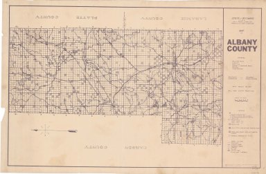
Title
Albany County Map
Date
1937-1946
Description
Albany County Map by State Mineral Supervisor Pierre LaFleiche, drafted by HG Lowman includes oil & gas fields, drainage, township, range, state land, primary & secondary roads WPA Project #6008 1/1937, 1946 Blueline
Category - Type
Map-County/Albany
Title
Big Horn County Map
Date
1937-1951
Description
Big Horn County Map by State Mineral Supervisor Pierre LaFleiche, drafted by HG Lowman includes oil & gas fields, drainage, township, range, state land, primary & secondary roads WPA Project 12/1937, rev 1945, rev 1951, 1 set blueline paper, 2 sets vellum
Category - Type
Map-County/Big Horn
Title
Carbon County Map
Date
1937-1951
Description
Carbon County Map by State Mineral Supervisor Pierre LaFleiche, drafted by HG Lowman includes oil & gas fields, drainage, township, range, state land, primary & secondary roads WPA Project 8/1937, 1946, 1951, 1 set blueline paper, 2 sets vellum, 1 set mylar
Category - Type
Map-County/Carbon
Title
Goshen County Map
Date
1937-1951
Description
Goshen County Map by State Mineral Supervisor Pierre LaFleiche, drafted by HG Lowman includes oil & gas fields, drainage, township, range, state land, primary & secondary roads WPA Project #6999 4/1937, 1945, 1951, 1 set blueline paper, 2 sets vellum
Category - Type
Map-County/Goshen
Title
Laramie County Map
Date
1938
Description
Laramie County Map by WY Highway Dept Planning & Research Div, US Dept of Commerce, Bureau of Public Roads includes buildings, air routes, township, range, roads, natural features, drainage, railroads, towns, 1936 revised in 1938
Category - Type
Map-County/Laramie
Title
Washakie County Map
Date
1938
Description
Washakie County Map by Bell & Donnell, Worland, WY includes township, range, school district boundaries, national forests, stock drive way, schools, irrigation district boundaries, Blueline, Colored
Category - Type
Map-County/Washakie
Title
Platte County Map
Date
1940
Description
Platte County Map by Albert B Bartlett, Platte County Surveyor includes township, range, towns, rivers, creeks, school districts, electrical & gas lines, roads, highways
Category - Type
Map-County/Platte
Title
Platte County District Court civil case 7-184, DR 14, Enlargement Application Map of WY Development Company, No. 1 & No 2 Canals & Tunnels
Date
1941
Description
Platte County District Court civil case 7-184, DR 14, Enlargement Application Map of WY Development Company, No. 1 & No 2 Canals & Tunnels, sheet 1, includes Township 22 - 25, Range 67 - 70, canals, rivers, creeks, reservoirs, lake, tunnel, acreage, 1 set with 1 sheet blueline paper
Category - Type
Court Exhibits
Title
Platte County District Court civil case 7-184, DR 15, Enlargement Application Map of WY Development Company, No. 1 & No 2 Canals & Tunnels
Date
1941
Description
Platte County District Court civil case 7-184, DR 15, Enlargement Application Map of WY Development Company, No. 1 & No 2 Canals & Tunnels, sheet 2, includes Township 22 - 24, Range 69 - 71, canals, rivers, creeks, ditches, lateral, 1 set with 1 sheet blueline paper
Category - Type
Court Exhibits
Title
Weston County Map
Date
1941
Description
Weston County Map by WY Highway Dept Planning & Research Div, US Dept of Commerce, Bureau of Public Roads includes buildings, air routes, township, range, roads, natural features, drainage, railroads, towns
Category - Type
Map-County/Weston
Title
Platte County District Court civil case 6-145, DR 7, Plaintiff Exhibit 2, Plat Township 25, Range 67 & Range 6
Date
1942
Description
Platte County District Court civil case 6-145, DR 7, Plaintiff Exhibit 2, Plat Township 25, Range 67 & Range 68, includes color-coded sections-red is deeded land and blue is leased land, 1 set with 1 sheet color coded paper (2 pages taped together)
Category - Type
Court Exhibits
Title
Platte County District Court civil case 6-145, DR 8, Plaintiff Exhibit 2, Plat Township 26, Range 69
Date
1942
Description
Platte County District Court civil case 6-145, DR 8, Plaintiff Exhibit 2, Plat Township 26, Range 69, includes color-coded sections-red is deeded land and blue is leased land, 1 set with 1 sheet color-coded paper
Category - Type
Court Exhibits
Title
Big Horn County Map
Date
1946
Description
Big Horn County Map by WY Highway Dept, Planning & Research Div, US Dept of Commerce, Bureau of Public Roads includes buildings, air routes, township, range, roads, natural features, drainage, railroads, towns 2 copies
Category - Type
Map-County/Big Horn
Title
Johnson County Map
Date
1946
Description
Johnson County Map by WY Highway Dept Planning & Research Div, US Dept of Commerce, Bureau of Public Roads includes buildings, air routes, township, range, roads, natural features, drainage, railroads, towns
Category - Type
Map-County/Johnson
Title
Natrona County Map
Date
1946
Description
Natrona County Map by WY Highway Dept Planning & Research Div, US Dept of Commerce, Bureau of Public Roads includes buildings, air routes, township, range, roads, natural features, drainage, railroads, towns 2 sheets, 2 sets
Category - Type
Map-County/Natrona
Title
Platte County District Court civil case 7-184, DR 10, Map of the Wheatland Irrigation District
Date
1946
Description
Platte County District Court civil case 7-184, DR 10, Map of the Wheatland Irrigation District, includes townships, ranges, sections, land ownership, railroads, roads, highways, reservoirs, lakes, ditches, district boundaries, electric lines, Governor Districts, 1 set with 1 sheet color-coded blueline paper
Category - Type
Court Exhibits
Title
Sheridan County Map
Date
1946
Description
Sheridan County Map by WY Highway Dept Planning & Research Div, US Dept of Commerce, Bureau of Public Roads includes buildings, air routes, township, range, roads, natural features, drainage, railroads, towns
Category - Type
Map-County/Sheridan
Title
Laramie County Map
Date
1946 Circa
Description
Laramie County Map by Murphy Map Company, Missouri includes township, range, roads, highways, interstates, towns, land owners 1 large Xerox Note: Reference only cannot be duplicated
Category - Type
Map-County/Laramie
Title
Carbon County Map
Date
1947
Description
Carbon County Map by WY Highway Dept includes township, range, towns, schools post offices, radio stations, oil & gas wells, mines, farms, cemeteries, airfields, drainage, rivers, creeks, roads, highways, railroads, bridges, towns, 3 copies
Category - Type
Map-County/Carbon
Title
Carbon County Map
Date
1947
Description
Carbon County Map by WY Highway Dept includes township, range, towns, schools post offices, radio stations, oil & gas wells, mines, farms, cemeteries, airfields, drainage, rivers, creeks, roads, highways, railroads, bridges, towns, 3 copies
Category - Type
Map-County/Carbon
|