Who What Where WhenREMOVEWHAT
WHEREShow More |
REFINE
Search Results: All Fields similar to 'Mineral supervisor' and Where equal to '2'
1-9 of 9
Title
Big Horn County Map
Date
1937-1945
Description
Big Horn County Map by State Mineral Supervisor Pierre LaFleiche, drafted by HG Lowman includes oil & gas fields, drainage, township, range, state land, primary & secondary roads WPA Project1/1937, 1945, 2 sets
Category - Type
Map-County/Big Horn
Title
Big Horn County Map
Date
1937-1951
Description
Big Horn County Map by State Mineral Supervisor Pierre LaFleiche, drafted by HG Lowman includes oil & gas fields, drainage, township, range, state land, primary & secondary roads WPA Project 12/1937, rev 1945, rev 1951, 1 set blueline paper, 2 sets vellum
Category - Type
Map-County/Big Horn
Title
Laramie County Map
Date
1936-1951
Description
Laramie County Map by State Mineral Supervisor Pierre LaFleiche, drafted by HG Lowman includes oil & gas fields, drainage, township, range, state land, primary & secondary roads WPA Project 6999 ca1936, 1945, 1951, 1 set blueline paper, 2 sets vellum, 1 set mylar, 1 set linen
Category - Type
Map-County/Laramie
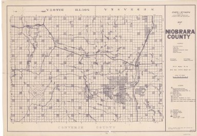
Title
Niobrara County Map
Date
1936-1945
Description
Niobrara County Map by State Mineral Supervisor Pierre LaFleiche, Drafted by HG Lowman includes oil & gas fields, township, range, state land, primary & secondary roads WPA Project 6008 1936, 1945
Category - Type
Map-County/Niobrara
Title
Niobrara County Map
Date
1936-1951
Description
Niobrara County Map by State Mineral Supervisor Pierre LaFleiche, Drafted by HG Lowman includes oil & gas fields, drainage, township, range, state land, primary & secondary roads WPA Project 109, 6/1936, rev 1945, rev 1951, 1 set blueline paper, 2 sets vellum
Category - Type
Map-County/Niobrara
Title
South Pass Mining District Field Notes of Charles Van Sickle & EH Fourt Mining Claim, known as Mahomet Group
Date
1898
Description
South Pass Mining District Field Notes of Charles Van Sickle & EH Fourt Mining Claim, known as Mahomet Group, consisting of the Alpine, Ben Hur, Wolverine, Charles Dickens & J.C.S Lodes in Township 29, Range 100, Section 20 by Newton H Brown, US Deputy Mineral Supervisor, 6 sheets paper (undersized)
Category - Type
Map-Site
1-9 of 9
|